
Official websites use .gov
A .gov
website belongs to an official government organization in the
United States.
Secure .gov websites use HTTPS
A lock
(
) or https:// means you've safely
connected to the .gov website. Share sensitive information only
on official, secure websites.


2023 MVUM Maps
User Guide | Frequently Asked Questions and More Information | 2015 Travel Analysis Report | Roads Analysis Comment Form | Heppner Ranger District Maps | North Fork John Day Ranger District Maps | Walla Walla Ranger District Maps | Pomeroy Ranger District Maps
 **New** Download MVUMs with your iOS Mobile Device (iPad, iPhone, iPod Touch) [note: the 2023 MVUM maps are available in Avenza]

Umatilla National Forest's 2023 Motor Vehicle Use Maps
2022 Winom-Frazier OHV Complex and Desolation OHV Trail System Map - May 31, 2022 (pdf file - 466kb)

2023 Maps Uploaded 03/22/2023
North Fork John Day Ranger District
|
View .pdf files with Adobe Acrobat Reader Adobe offers a free service for blind or visually impaired users at http://access.adobe.com. Adobe.com provides a set of free tools that allow visually disabled users to read document in Adobe PDF format. These tools convert PDF documents to formats that can then be read by many screen reading programs. |

User guide
 |
Roads Analysis Comment Form
The Umatilla National Forest completed an internal travel analysis in 2015 on the forest’s road system, as directed by the Travel Management Rule - Subpart A. At that time we collected information on current system roads including open and closed roads at all maintenance levels. At the same time we invited public input on what forest roads they use and why.
The completed 2015 Travel Management Rule-Subpart A Report will inform future decision makers on site-specific projects. Those future site specific projects will require the appropriate NEPA and provide an additional public involvement process at that time.
This was only an analysis process. No roads were closed as a result of completing the analysis. Although the analysis was completed in 2015, we are still interested in how, where, and why you use your National Forest system roads and would appreciate hearing from you. Thank you for taking the time to tell us what you think! Roads Analysis Comment Form
FAQS and More Information
What are Motor Vehicle Use Maps? | Where can I get them? | What has changed? | How do I print the maps? | What does a MVUM show me? | Does the MVUM also show non-motorized trails and over-snow motorized vehicle uses? | What do you mean by vehicle class / route types? | What do you mean by a seasonal designation? | Are there road and trail route numbers on the ground that correlate to the MVUM? | When will the MVUM become enforceable? | Will I be able to retrieve game using my ATV this hunting season? | Are there allowances for dispersed camping? | Does this affect parking on the Forest? | Will I be able to travel cross-country from one designated system to another? | Is there anything else I should know?
What are Motor Vehicle Use Maps?
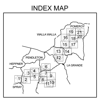
The Umatilla National Forest Motor Vehicle Use Map (MVUM) is a single purpose map developed to display National Forest System routes (roads, trails and areas) designated for motorized travel. Twenty-one maps, printed front and back on a total of eleven sheets, make up the Umatilla National Forest’s MVUM collection. These maps display designations by vehicle class, seasons of use, as well as general travel rules and regulations and will be updated annually.
The Motor Vehicle Use Map shows the roads, trails and areas where you can take your Off Highway Vehicle. These roads, trails and areas are designated by type of motor vehicle allowed and the allowable season of use. For example, on National Forest System Roads that allow motor vehicle use the 2 primary designations are Roads Open to Highway Legal Vehicles Only and Roads Open to All Vehicles. Some examples of the vehicle types that are highway legal are: passenger cars, pickup trucks, SUVs and motorcycles that by state law are licensed for general operation on all public roads within the state. Some examples of vehicles that are not highway legal include: ATVs, UTVs (side by sides), off road motorcycles, golf carts and any other motor vehicle that by state law is not licensed for general operation on all public roads in the state.
A road that is designated as open to all motor vehicles allows any motor vehicle both licensed and unlicensed for general operation on all public roads in the state which would include all Off Highway Vehicles.
Refer to the appropriate Motor Vehicle Use Map to determine the allowed motor vehicle use for a specific National Forest System road, trail or area. These maps are available at all National Forest offices and on all National Forest web sites. Call your national forest if you have questions.National Forest System routes not shown on the MVUM are not designated for motorized vehicle travel. Routes designated for motorized use may not always be clearly identified on the ground with a route number, but will be identified on the MVUM. It is your responsibility to refer to the MVUM to determine designated routes for motor vehicle use.
The MVUM is a black and white map with no topographical features. It is best used in conjunction with a Forest Visitor Map or other topographical map.
Where can I get them?
- The MVUM is posted on this webpage for printing and paper copies are available, free of charge, at each of the Umatilla National Forest offices.
- Also available is the companion brochure "A Guide to Using Your New MVUM."
Can I use the MVUMs with my iOS Mobile Device (iPad, iPhone, iPod Touch)?
If you own a iOS mobile device such as an iPad, iPhone or iPod Touch you can take the Umatilla National Forest MVUMs with you. This handy free app, http://www.avenza.com/pdf-maps, allows GPS equipped iOS mobile devices to:
- View your location on the PDF MVUM using the built-in GPS device (iPad, iPhone, iPod Touch)
- Measure distances and areas
- Plot waypoints
- View maps offline
- And more
- http://www.avenza.com/pdf-maps
The above link does not imply an endorsement by the US Government of the product offered. It is merely offered as a convenience for users who may wish to install a free application on their smartphone. For more information please see https://www.fs.usda.gov/about-agency/disclaimers-important-notices
How do I print the MVUM?
Full-size versions of the MVUM are 36” x 44” and cannot be printed on conventional home printers. A full-size version can only be printed from a large plotter. Many local copy shops, engineering and survey businesses can print the map. To be legible, only a portion of an MVUM can be printed on 8 ½” x 11” paper using home printers.
Here are three easy steps to help you print a map and ensure you have the accompanying text, legend and seasonal designation table necessary to interpret the MVUM.
Step 1:
Open the map you wish to print from. To do this, click on the map number located on the site map or in the map/designation table chart. Both are located below.
Navigate and zoom in to the area on the map you want to print. With Adobe Acrobat®, select File, Print, and use the “Print Current View” function to print the view on your screen.
Step 2:
Open and print the corresponding designation tables (specific to the map you are using.) Designation tables are located in the map/table chart below.
Step 3:
Open and print the Map Text and Legend. The text and legend are consistent on each MVUM and will only need to be printed once.
What does a MVUM show me?
- The map displays all National Forest System roads, trails and areas designated for public motorized vehicle use. It also states that driving anywhere other than on those roads, trails, and areas designated on the MVUM is prohibited (36 CFR 261.13)
- Motorized vehicles include, but are not limited to, motorcycles, ATV’s, and 4-wheel drive vehicles.
- Designation details include vehicle class, season of use, and general rules applicable to motorized access.
- Limited motor vehicle access may occur on routes not shown on the MVUMs, for the purposes of administrative access by Forest Service personnel; fire and law enforcement; emergency purposes; and by persons authorized by a written special use permit or contract from the Forest Service.
Does the MVUM also show non-motorized trails and over-snow motorized vehicle uses?
No, a visitor use map or recreation opportunity map will provide information on non-motorized routes, including biking, hiking, and horse trails. Over-snow vehicle use is exempted from designation on the MVUM.
What do you mean by vehicle class / route types?
Vehicle class refers to certain categories of motorized vehicles. The following are typical vehicle class route designations:
- Roads open to highway legal vehicles only (licensed)
- Trails open to motorcycles only (single track)
It's important to understand that routes and areas designated for motorized travel by certain vehicle classes do not mean they are suitably maintained for travel using those vehicles. It simply means it is legal to use them. For example, many low standard roads may be open to all motor vehicles. This designation includes passenger cars, although it may not be prudent to drive this type of vehicle on the route due to the condition of the surface or during inclement weather. Please check with local Forest Service offices for more information.
What do you mean by a seasonal designation?
Some routes or areas may only be designated for motorized travel during certain times of the year for various reasons, such as to reduce wildlife disturbance or reduce impacts to other resource values, like soil, water, and vegetation.
Are there road and trail route numbers on the ground that correlate to the MVUM?
Routes designated for motorized use may not always be clearly signed with a route number. In some cases, a sign may exist at the entrance of the road or trail, with symbols indicating which classes of vehicles are allowed. Routes designated for motorized uses will be identified on the MVUM. In case of a discrepancy, the MVUM shall take precedence. We urge you to please report any such discrepancies, so they can be corrected.
It is the responsibility of the user to determine if they are on a route designated for the motor vehicle being used. MVUMs will be developed for each administrative unit nationwide. It is not only a tool for motorized users, but also a consistent and standardized law enforcement tool.
When will the MVUM become enforceable?
The MVUM is enforceable now that the map has been posted to the web and is available to the public in a hard copy format.
Will I be able to retrieve game using my ATV this hunting season?
Now that the MVUM is implemented, the prohibition on motor vehicle use off the designated system (36 CFR 261.13) is in effect and traveling cross-country to retrieve game is not allowed.
Are there allowances for dispersed camping?
Dispersed campsites are in areas that have not been improved or developed for recreation. Generally, no facilities are available at these sites and no fee is required. To protect valuable resources when camping in a dispersed site, please select your campsite on foot, use proper precautions when building a campfire, and implement “leave no trace” techniques.
The following rules apply throughout the forest:
- Vehicle use on established routes is allowed within 300 feet of an open road, solely for the purpose of accessing a dispersed campsite.
- Avoid camping within 50 feet of a body of water.
- You may not move barriers such as gates, rocks, berms, or signs, or circumvent them by motorized means.
- It is unlawful to construct roads or trails.
- It is unlawful to cut, damage, or harm vegetation.
- Motorized vehicles must stay on designated roads or parking sites within developed areas such as campgrounds, picnic areas, trailheads, and boat launches.
Does this affect parking on the Forest?
Motor vehicles can park in parking areas designated such as campgrounds and trailheads. Also, parking is allowed one vehicle length from the edge of designated routes, when it is safe to do so without causing damage to natural resources or facilities, unless prohibited by law , a traffic sign, or a forest order.
Will I be able to travel cross-country from one designated system to another?
No, cross-country travel is prohibited. There are no cross-country areas designated for motorized use on the Umatilla National Forest.
Is there anything else I should know?
 The Umatilla, Malheur, and Wallowa-Whitman National Forests require the Oregon State Parks and Recreation ATV Operating Decal when operating ATVs. Decals can be purchased through the Oregon State Parks and Recreation offices or their vendors. A current vendor list is available online at https://www.oregon.gov/OPRD/ATV/Pages/index.aspx. Proceeds from the sales of the decals are available competitively to help support ATV activities in Oregon including the maintenance of current trails, construction of new trails, and trail management and enforcement of regulations governing use.