
Domestic Names
Downloadable GNIS Data
Domestic names data products in additional formats are available for download.
GNIS Domestic Names Search Application Training Video
Learn tips and tricks when looking for geographic names in GNIS.
Place names within the United States and its dependent areas are available in the Geographic Names Information System (GNIS) and are the responsibility of the Domestic Names Committee (DNC) of the U.S. Board on Geographic Names (BGN).
What is the Domestic Names Committee?
The Domestic Names Committee (DNC) of the U.S. Board on Geographic Names (BGN) is responsible for standardizing the names of places, features, and areas within the United States and its dependent areas. The DNC consists of members and deputies representing the Departments of the Interior, Commerce, Agriculture, Defense, and Homeland Security, as well as the United States Postal Service, Government Publishing Office, and Library of Congress. The Executive Secretary and staff support for BGN’s domestic names activities and the maintenance of names of Antarctic features are provided by the U.S. Geological Survey (USGS). The DNC meets monthly to decide on geographic names issues. For more details see the DNC’s Principles, Policies, and Procedures.
Domestic Names in the Geographic Names Information System

The Geographic Names Information System (GNIS) is the Federal and national standard for geographic names. The U.S. Geological Survey's National Geospatial Program developed the GNIS in support of the U.S. Board on Geographic Names and to serve as the official repository of domestic geographic names data. GNIS serves as the official geographic names source for all Federal departments and Federal digital and printed products.
Find Domestic Names in the GNIS
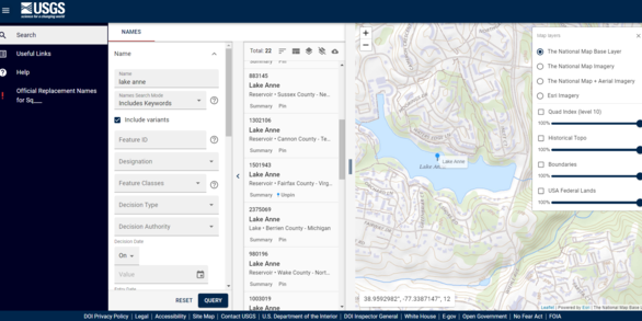
Using the GNIS Domestic Names Search Application, users can search for names in the database, view the location(s) on various base maps, and link to a more detailed summary page. The search results can be downloaded. Help documentation is available with the application.
Download Domestic Names
Domestic Names in GNIS are available for direct download from The National Map Staged Products Directory. For more information, go to the Download GNIS Data page. These files are updated every other month.
What is in GNIS?
The GNIS contains current and historical information about physical geographic features in the United States, its dependent areas, and Antarctica. The database contains the federally recognized name of each feature and defines its location by State, county, USGS topographic map, and geographic coordinates. GNIS also lists variant names, which are non-official names by which a feature is or was known. Other attributes include unique Feature ID and feature class. Feature classes under the purview of the U.S. Board on Geographic Names include natural features, unincorporated populated places, canals, channels, reservoirs, and more. Also within GNIS are civil, census, and military features that are maintained via an agreement between the Census Bureau and USGS. Click here for a full list of domestic names feature classes. Go to What is the Geographic Names Information System (GNIS)? for more information.
What is not in GNIS?
GNIS does not include roads, highways, administrative, or cultural features. In 2021 the following geographic features referred to as “administrative” (cultural or man-made) were removed from GNIS: airport, bridge, building, cemetery, church, dam, forest, harbor, hospital, mine, oilfield, park, post office, reserve, school, tower, trail, tunnel, and well. Some administrative feature data are maintained in other The National Map data themes. See The National Map Supporting Themes page for information on transportation, structures, boundaries, and more.
Contacts
If you have questions about the DNC, please contact BGNExec@usgs.gov.
If you have questions about GNIS, please contact TNM_Help@usgs.gov.
For information on how to submit a proposal to the U.S. Board on Geographic Names for a new name or name change, please see How Do I?


