Rio Grande Gorge, New Mexico
BLM
U.S. DEPARTMENT OF THE INTERIOR
BUREAU OF LAND MANAGEMENT
Mimbres Black-on-White Bowl, New Mexico Lesser Prairie Chicken, New Mexico Rafting the Rio Grande, New Mexico Wild Horse, New Mexico Oil Rig, Oklahoma
New Mexico
BLM>New Mexico>Rio Puerco Field Office>KKTR Record of Decision and RMP
Print Page

Kasha-Katuwe Tent Rocks National Monument
Record of Decision and Resource Management Plan


The Kasha-Katuwe Tent Rocks National Monument Resource Management Plan (RMP) is available for your review. It was prepared by the Bureau of Land Management (BLM) in consultation with the Pueblo de Cochiti, federal and state agencies, taking into account public comments received during this planning effort. The document provides a framework for the future management direction and appropriate use of the Monument and planning area, located in Sandoval County, New Mexico. It contains both land use planning decisions and implementation decisions to facilitate management of the area.

The RMP/Final EIS was developed in accordance with the National Environmental Policy Act of 1969 (NEPA), and the Federal Land Policy and Management Act of 1976. The document is mainly based on Alternative B, the agency’s preferred alternative in the Draft RMP/EIS, which was released on November 4, 2005.


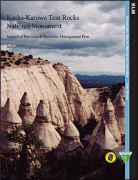
Cover of Kasha-Katuwe Tent Rocks National Monument Record of Decision and Resource Management Plan 

Documents

Record of Decision

Dear Reader Letter

Table of Contents

Errata Sheet 1
Errata Sheet 2

Glossary
References
Acronyms and Abbreviations

Resource Management Plan
Appendices 
  • Appendix A – Proclamation 7394 of January 17, 2001
  • Appendix B – Noxious Weed Prevention
  • Appendix C – Best Management Practices for Use with Vegetation Treatment Methods
  • Appendix D – Visual Resource Management Classes & Objectives
  • Appendix E – Recreation Opportunity Spectrum
  • Appendix F – Section 7 Correspondence with U.S. Fish & Wildlife Service
  • Appendix G – Special-Status & Sensitive Animal Species in Sandoval County
  • Appendix H – Plant Species of Concern in Sandoval County
  • Appendix I – Wild & Scenic River Evaluation
  • Appendix J – Vegetation treatments & Fire Management
  • Appendix K – Preparers of the Plan 
Maps
  • Map 1 – Regional Map
  • Map 2 – Kasha-Katuwe Tent Rocks National Monument
  • Map 3 – Planning Area Acreages
  • Map 4 – Roads and Trails
  • Map 5 – Potential Hazardous Fuel (Vegetative) Treatment Areas
  • Map 6 – Livestock Grazing Allotment in the Monument & Southwest Acquisition
  • Map 7 – ROS (Recreation Opportunity Spectrum) Classifications
  • Map 8 – Peralta Canyon Riparian Study Area
  • Map 9 – Soil Map Units (SMUs)
  • Map 10 – Areas with Special Geologic features
  • Map 11 – VRM (Visual Resource Management) Classifications