
Kīlauea Volcano Erupts
This is a developing story, so please keep checking for daily updates
Today's update for June 21st, 2018 will be the last of the daily updates on this USGS feature story. We encourage you to keep checking the USGS Hawaiian Volcano Observatory (HVO) Kīlauea status website for daily activity updates. You can also visit the USGS Facebook page and the USGS Twitter feed as updates become available. For press inquiries, please email volcanomedia@usgs.gov.
If you would like a comprehensive web resource for all-things-Kilauea, please go to the "Resources for 2018 Kīlauea Lower East Rift Zone and Summit Activity" webpage for a variety related links.
UPDATE, 6/21/18, 10:31pm HST
Kīlauea Volcano Lower East Rift Zone
The eruption in the lower East Rift Zone (LERZ) continues with little change.

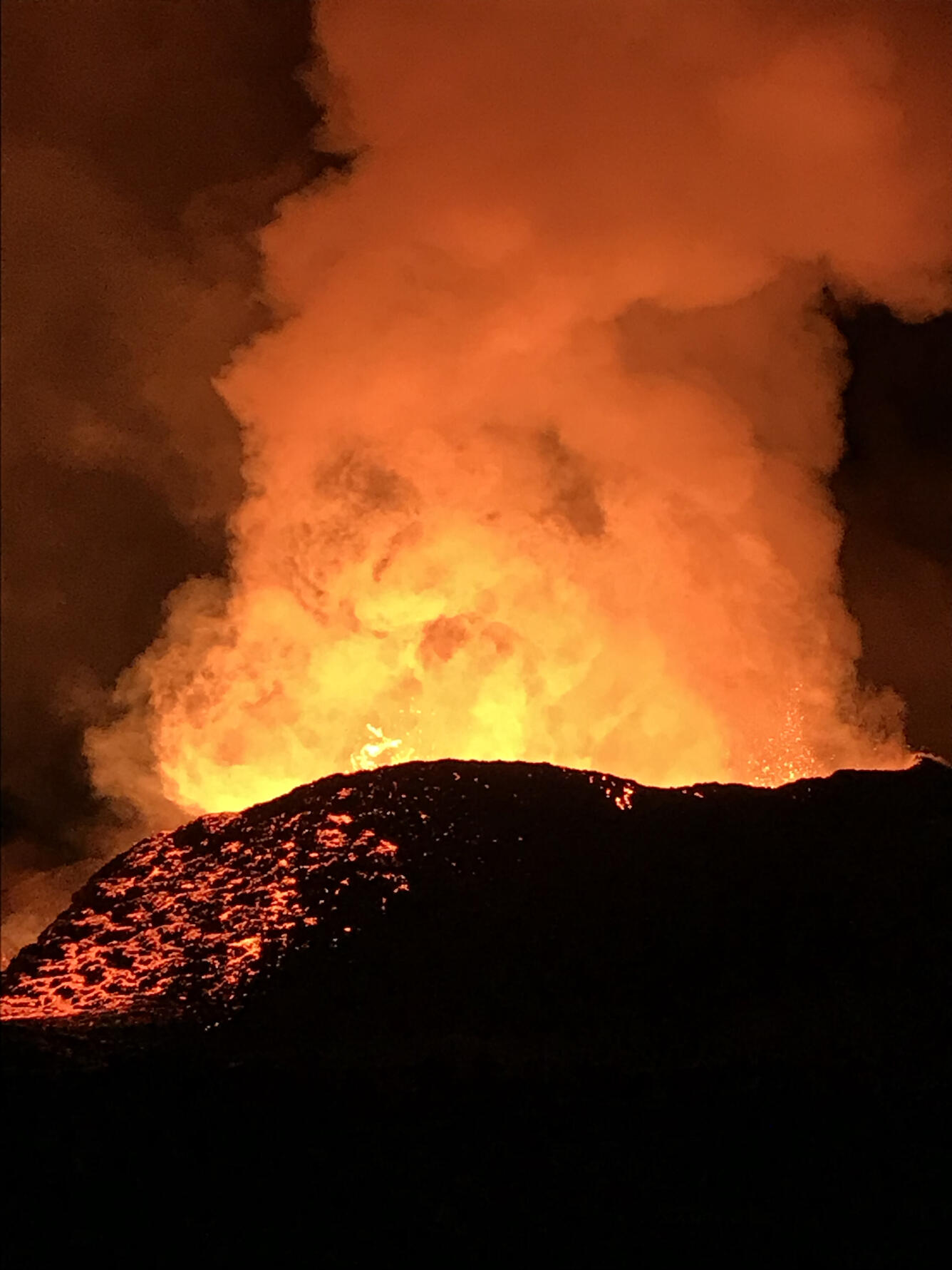
Lava fountains from the Fissure 8 spatter cone continue to feed the established channel shuttling lava to the Kapoho coastline. A dominant ocean entry on the south edge of the flow front produced a large laze plume throughout the day. Upslope, minor overflows from the channel occurred periodically, but all were short-lived and did not extend beyond the current flow field. Fissure 6 oozed lava sporadically through the early morning hours. Fissures 16/18 and 22 displayed incandescence early this morning.
Pele's hair and other lightweight volcanic glass fragments from the lava fountain at Fissure 8 continue to fall downwind of the fissure, dusting the ground within a few hundred meters (yards) of the vent. High winds may waft lighter particles to greater distances. Residents are urged to minimize exposure to these volcanic particles, which can cause skin and eye irritation similar to volcanic ash.
The most recent map of lava flows can be found at https://volcanoes.usgs.gov/volcanoes/kilauea/multimedia_maps.html
HVO field crews are on site tracking the fountains, lava flows, and spattering from Fissure 8 as conditions allow and are reporting information to Hawaii County Civil Defense. Observations are also collected on a daily basis from cracks in the area of Highway 130; no changes in temperature, crack width, or gas emissions have been noted for several days.
Volcanic gas emissions remain very high from Fissure 8 eruptions. Returning trade wind conditions are expected to bring VOG to the southern and western parts of the Island of Hawaii. VOG information can be found at https://vog.ivhhn.org/
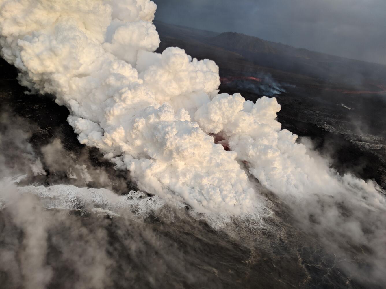
The ocean entry is a hazardous area. Venturing too close to an ocean entry on land or the ocean exposes you to flying debris from sudden explosive interaction between lava and water. Also, the lava delta is unstable because it is built on unconsolidated lava fragments and sand. This loose material can easily be eroded away by surf, causing the new land to become unsupported and slide into the sea. Additionally, the interaction of lava with the ocean creates "laze", a corrosive seawater plume laden with hydrochloric acid and fine volcanic particles that can irritate the skin, eyes, and lungs.
Magma continues to be supplied to the Lower East Rift Zone. Seismicity remains relatively low in the area with numerous small magnitude earthquakes and low amplitude background tremor. Higher amplitude tremor is occasionally being recorded on seismic stations close to the ocean entry.
Additional ground cracking and outbreaks of lava in the area of the active fissures are possible. Residents downslope of the region of fissures should heed all Hawaii County Civil Defense messages and warnings.

Kīlauea Volcano Summit
AT 1:13pm HST, a collapse/explosion event occurred at the summit of Kīlauea Volcano. The resulting gas plume was ash-poor and rose less than 1,000 ft above the ground surface. Seismicity dropped from pre-event levels of 30-35 earthquakes per hour to less than 20 per hour after the collapse/explosion. By 10:00 p.m. HST, seismicity was back up to 25-30 events per hour. Inward slumping of the rim and walls of Halemaʻumaʻu continues in response to ongoing subsidence at the summit.
Sulfur dioxide emissions from the volcano's summit have dropped to levels that are about half those measured prior to the onset of the current episode of eruptive activity. This gas and minor amounts of ash are being transported downwind, with small bursts of ash and gas accompanying intermittent explosive activity.
For forecasts of where ash would fall under forecast wind conditions, please consult the Ash3D model output here: https://volcanoes.usgs.gov/observatories/hvo/ash_information.html
Information on volcanic ash hazards and how to prepare for ash fall maybe found at http://www.ivhhn.org/information#ash (health impacts) OR https://volcanoes.usgs.gov/volcanic_ash/ (other impacts).

UPDATE, 6/21/18, 6:11pm HST
Kīlauea Volcano Lower East Rift Zone
The eruption in the lower East Rift Zone (LERZ) continues with little change.

Lava fountains from the Fissure 8 spatter cone continue to feed the established channel that transports lava to the ocean at the Kapoho coastline. One main ocean entry on the south edge of the flow front at the coast is producing a laze plume that is being blown onshore. No overflows from the channel were observed this morning. Fissure 6 was weakly active overnight with at least one short flow active visible in the PGcam. Fissure 16/18 and 22 displayed some incandescence early this morning.
Pele's hair and other lightweight volcanic glass fragments from the lava fountain at Fissure 8 continue to fall downwind of the fissure, dusting the ground within a few hundred meters (yards) of the vent. High winds may waft lighter particles to greater distances. Residents are urged to minimize exposure to these volcanic particles, which can cause skin and eye irritation similar to volcanic ash.
The most recent map of lava flows can be found at https://volcanoes.usgs.gov/volcanoes/kilauea/multimedia_maps.html
HVO field crews are on site tracking the fountains, lava flows, and spattering from Fissure 8 as conditions allow and are reporting information to Hawaii County Civil Defense. Observations are also collected on a daily basis from cracks in the area of Highway 130; no changes in temperature, crack width, or gas emissions have been noted for several days.
Volcanic gas emissions remain very high from Fissure 8 eruptions. Returning trade wind conditions are expected to bring VOG to the southern and western parts of the Island of Hawaii. VOG information can be found at https://vog.ivhhn.org/

The ocean entry is a hazardous area. Venturing too close to an ocean entry on land or the ocean exposes you to flying debris from sudden explosive interaction between lava and water. Also, the lava delta is unstable because it is built on unconsolidated lava fragments and sand. This loose material can easily be eroded away by surf, causing the new land to become unsupported and slide into the sea. Additionally, the interaction of lava with the ocean creates "laze", a corrosive seawater plume laden with hydrochloric acid and fine volcanic particles that can irritate the skin, eyes, and lungs.
Magma continues to be supplied to the Lower East Rift Zone. Seismicity remains relatively low in the area with numerous small magnitude earthquakes and low amplitude background tremor. Higher amplitude tremor is occasionally being recorded on seismic stations close to the ocean entry.
Additional ground cracking and outbreaks of lava in the area of the active fissures are possible. Residents downslope of the region of fissures should heed all Hawaii County Civil Defense messages and warnings.
Kīlauea Volcano Summit
AT 1:13 PM HST, a collapse/explosion event occurred at the summit of Kīlauea Volcano. The gas plume had little ash in it and wafted no more than 1,000 ft above the ground. Inward slumping of the rim and walls of Halemaʻumaʻu continues in response to ongoing subsidence at the summit.
Sulfur dioxide emissions from the volcano's summit have dropped to levels that are about half those measured prior to the onset of the current episode of eruptive activity. This gas and minor amounts of ash are being transported downwind, with small bursts of ash and gas accompanying intermittent explosive activity.
For forecasts of where ash would fall under forecast wind conditions, please consult the Ash3D model output here: https://volcanoes.usgs.gov/observatories/hvo/ash_information.html
Information on volcanic ash hazards and how to prepare for ash fall maybe found at http://www.ivhhn.org/information#ash (health impacts) OR https://volcanoes.usgs.gov/volcanic_ash/ (other impacts).
UPDATE, 6/21/18, 9:23pm HST
Kīlauea Volcano Lower East Rift Zone
The eruption in the lower East Rift Zone (LERZ) continues with little change.
Lava fountains from the Fissure 8 spatter cone continue to feed the established channel that transports lava to the ocean at the Kapoho coastline. One main ocean entry on the south edge of the flow front at the coast is producing a laze plume that is being blown onshore. No overflows from the channel were observed this morning. Fissure 6 was weakly active overnight with at least one short flow active visible in the PGcam. Fissure 16/18 and 22 displayed some incandescence early this morning.
Pele's hair and other lightweight volcanic glass fragments from the lava fountain at Fissure 8 continue to fall downwind of the fissure, dusting the ground within a few hundred meters (yards) of the vent. High winds may waft lighter particles to greater distances. Residents are urged to minimize exposure to these volcanic particles, which can cause skin and eye irritation similar to volcanic ash.
The most recent map of lava flows can be found at https://volcanoes.usgs.gov/volcanoes/kilauea/multimedia_maps.html
HVO field crews are on site tracking the fountains, lava flows, and spattering from Fissure 8 as conditions allow and are reporting information to Hawaii County Civil Defense. Observations are also collected on a daily basis from cracks in the area of Highway 130; no changes in temperature, crack width, or gas emissions have been noted for several days.
Volcanic gas emissions remain very high from Fissure 8 eruptions. Returning trade wind conditions are expected to bring VOG to the southern and western parts of the Island of Hawaii. VOG information can be found at https://vog.ivhhn.org/
The ocean entry is a hazardous area. Venturing too close to an ocean entry on land or the ocean exposes you to flying debris from sudden explosive interaction between lava and water. Also, the lava delta is unstable because it is built on unconsolidated lava fragments and sand. This loose material can easily be eroded away by surf, causing the new land to become unsupported and slide into the sea. Additionally, the interaction of lava with the ocean creates "laze", a corrosive seawater plume laden with hydrochloric acid and fine volcanic particles that can irritate the skin, eyes, and lungs.
Magma continues to be supplied to the Lower East Rift Zone. Seismicity remains relatively low in the area with numerous small magnitude earthquakes and low amplitude background tremor. Higher amplitude tremor is occasionally being recorded on seismic stations close to the ocean entry.
Additional ground cracking and outbreaks of lava in the area of the active fissures are possible. Residents downslope of the region of fissures should heed all Hawaii County Civil Defense messages and warnings.
Kīlauea Volcano Summit
Seismicity at the summit increased overnight with 30 to 35 events per hour by daybreak. Several earthquakes were felt in the Volcano area. Inward slumping of the rim and walls of Halemaʻumaʻu continues in response to ongoing subsidence at the summit.
Sulfur dioxide emissions from the volcano's summit have dropped to levels that are about half those measured prior to the onset of the current episode of eruptive activity. This gas and minor amounts of ash are being transported downwind, with small bursts of ash and gas accompanying intermittent explosive activity.
For forecasts of where ash would fall under forecast wind conditions, please consult the Ash3D model output here: https://volcanoes.usgs.gov/observatories/hvo/ash_information.html
Information on volcanic ash hazards and how to prepare for ash fall maybe found at http://www.ivhhn.org/information#ash (health impacts) OR https://volcanoes.usgs.gov/volcanic_ash/ (other impacts).
UPDATE, 6/20/18, 10:35pm HST
Kīlauea Volcano Lower East Rift Zone
The eruption in the lower East Rift Zone (LERZ) continues with little change.
Lava fountains up to 187 feet tall rise from the Fissure 8 spatter cone and feed the established channel that transports lava to the ocean at the Kapoho coastline. One main ocean entry is producing a billowing plume of laze that is being blown onshore. No overflows from the channel were observed this afternoon or evening. Fissure 16 appeared to be only fuming during the early afternoon overflight but later observations show it began mild spattering after sunset.
Pele's hair and other lightweight volcanic glass fragments from the lava fountain at Fissure 8 continue to fall downwind of the fissure, dusting the ground within a few hundred meters (yards) of the vent. High winds may waft lighter particles to greater distances. Residents are urged to minimize exposure to these volcanic particles, which can cause skin and eye irritation similar to volcanic ash.
The most recent map of lava flows can be found at https://volcanoes.usgs.gov/volcanoes/kilauea/multimedia_maps.html
HVO field crews are on site tracking the fountains, lava flows, and spattering from Fissure 8 as conditions allow and are reporting information to Hawaii County Civil Defense. Observations are also collected on a daily basis from cracks in the area of Highway 130; no changes in temperature, crack width, or gas emissions have been noted for several days.
Volcanic gas emissions remain very high from Fissure 8 eruptions. VOG information can be found at https://vog.ivhhn.org/
The ocean entry is a hazardous area. Venturing too close to an ocean entry on land or the ocean exposes you to flying debris from sudden explosive interaction between lava and water. Also, the lava delta is unstable because it is built on unconsolidated lava fragments and sand. This loose material can easily be eroded away by surf, causing the new land to become unsupported and slide into the sea. Additionally, the interaction of lava with the ocean creates "laze", a corrosive seawater plume laden with hydrochloric acid and fine volcanic particles that can irritate the skin, eyes, and lungs.
Magma continues to be supplied to the Lower East Rift Zone. Seismicity remains relatively low in the area with numerous small magnitude earthquakes and low amplitude background tremor. Higher amplitude tremor is occasionally being recorded on seismic stations close to the ocean entry.
Additional ground cracking and outbreaks of lava in the area of the active fissures are possible. Residents downslope of the region of fissures should heed all Hawaii County Civil Defense messages and warnings.

Kīlauea Volcano Summit
Seismicity at the summit increased throughout the day following the abrupt drop after the 4:22am HST gas and ash emission this morning. Inward slumping of the rim and walls of Halemaʻumaʻu continues in response to ongoing subsidence at the summit.
Sulfur dioxide emissions from the volcano's summit have dropped to levels that are about half those measured prior to the onset of the current episode of eruptive activity. This gas and minor amounts of ash are being transported downwind, with small bursts of ash and gas accompanying intermittent explosive activity.
For forecasts of where ash would fall under forecast wind conditions, please consult the Ash3D model output here: https://volcanoes.usgs.gov/observatories/hvo/ash_information.html
Information on volcanic ash hazards and how to prepare for ash fall maybe found at http://www.ivhhn.org/information#ash (health impacts) OR https://volcanoes.usgs.gov/volcanic_ash/ (other impacts).
MORE INFORMATION
Subscribe to these messages: https://volcanoes.usgs.gov/vns2/
Webcam images: https://volcanoes.usgs.gov/volcanoes/kilauea/multimedia_webcams.html
Photos/Video: https://volcanoes.usgs.gov/volcanoes/kilauea/multimedia_chronology.html
Lava Flow Maps: https://volcanoes.usgs.gov/volcanoes/kilauea/multimedia_maps.html
Definitions of terms used in update: https://volcanoes.usgs.gov/volcanoes/kilauea/extra/definitions.pdf
Overview of Kīlauea summit (Halemaʻumaʻu) and East Rift Zone (Puʻu ʻŌʻō ) eruptions:
https://volcanoes.usgs.gov/volcanoes/kilauea/extra/background.pdf
Summary of volcanic hazards from Kīlauea eruptions:
https://volcanoes.usgs.gov/volcanoes/kilauea/extra/hazards.pdf
Recent Earthquakes in Hawai'i (map and list):
https://volcanoes.usgs.gov/hvo/earthquakes/
Explanation of Volcano Alert Levels and Aviation Color Codes:
https://volcanoes.usgs.gov/activity/alertsystem/index.php
https://pubs.usgs.gov/fs/2006/3139/
CONTACT INFORMATION:
askHVO@usgs.gov
The Hawaiian Volcano Observatory is one of five volcano observatories within the U.S. Geological Survey and is responsible for monitoring volcanoes and earthquakes in Hawai`i.
UPDATE, 6/20/18, 5:04pm HST
Kīlauea Volcano Lower East Rift Zone
The eruption in the lower East Rift Zone (LERZ) continues with little change.
Lava fountains from the Fissure 8 spatter cone continue to feed the established channel that transports lava to the ocean at the Kapoho coastline with one main entry area active at the south end of the flow front at the ocean. Upslope, short-lived overflows occur periodically but generally do not travel beyond the existing flow field. Fissures 6 and 16 appeared to be only fuming during our early afternoon overflight.
Pele's hair and other lightweight volcanic glass fragments from the lava fountain at Fissure 8 continue to fall downwind of the fissure, dusting the ground within a few hundred meters (yards) of the vent. High winds may waft lighter particles to greater distances. Residents are urged to minimize exposure to these volcanic particles, which can cause skin and eye irritation similar to volcanic ash.
The most recent map of lava flows can be found at https://volcanoes.usgs.gov/volcanoes/kilauea/multimedia_maps.html
HVO field crews are on site tracking the fountains, lava flows, and spattering from Fissure 8 as conditions allow and are reporting information to Hawaii County Civil Defense. Observations are also collected on a daily basis from cracks in the area of Highway 130; no changes in temperature, crack width, or gas emissions have been noted for several days.
Volcanic gas emissions remain very high from Fissure 8 eruptions. Shifting wind conditions are expected to bring VOG to nearly all of the Island of Hawaii. VOG information can be found at https://vog.ivhhn.org/
The ocean entry is a hazardous area. Venturing too close to an ocean entry on land or the ocean exposes you to flying debris from sudden explosive interaction between lava and water. Also, the lava delta is unstable because it is built on unconsolidated lava fragments and sand. This loose material can easily be eroded away by surf, causing the new land to become unsupported and slide into the sea. Additionally, the interaction of lava with the ocean creates "laze", a corrosive seawater plume laden with hydrochloric acid and fine volcanic particles that can irritate the skin, eyes, and lungs.

Magma continues to be supplied to the Lower East Rift Zone. Seismicity remains relatively low in the area with numerous small magnitude earthquakes and low amplitude background tremor. Higher amplitude tremor is occasionally being recorded on seismic stations close to the ocean entry.
Additional ground cracking and outbreaks of lava in the area of the active fissures are possible. Residents downslope of the region of fissures should heed all Hawaii County Civil Defense messages and warnings.
Kīlauea Volcano Summit
Seismicity at the summit continues to increase after abruptly decreasing after this morning's gas and ash emission. Inward slumping of the rim and walls of Halemaʻumaʻu continues in response to ongoing subsidence at the summit.
Sulfur dioxide emissions from the volcano's summit have dropped to levels that are about half those measured prior to the onset of the current episode of eruptive activity. This gas and minor amounts of ash are being transported downwind, with small bursts of ash and gas accompanying intermittent explosive activity.
For forecasts of where ash would fall under forecast wind conditions, please consult the Ash3D model output here: https://volcanoes.usgs.gov/observatories/hvo/ash_information.html
Information on volcanic ash hazards and how to prepare for ash fall maybe found at http://www.ivhhn.org/information#ash (health impacts) OR https://volcanoes.usgs.gov/volcanic_ash/ (other impacts).
UPDATE, 6/20/18, 9:02am HST
Kīlauea Volcano Lower East Rift Zone
The eruption in the lower East Rift Zone (LERZ) continues with little change.
Lava fountains from the Fissure 8 spatter cone continue to feed the established channel that transports lava to the ocean at the Kapoho coastline, where several entries are active. Upslope, short-lived overflows occur periodically but generally do not travel beyond the existing flow field. Fissures 6, 15, and 16 are periodically oozing lava and steaming.
Pele's hair and other lightweight volcanic glass fragments from the lava fountain at Fissure 8 continue to fall downwind of the fissure, dusting the ground within a few hundred meters (yards) of the vent. High winds may waft lighter particles to greater distances. Residents are urged to minimize exposure to these volcanic particles, which can cause skin and eye irritation similar to volcanic ash.
The most recent map of lava flows can be found at https://volcanoes.usgs.gov/volcanoes/kilauea/multimedia_maps.html
HVO field crews are on site tracking the fountains, lava flows, and spattering from Fissure 8 as conditions allow and are reporting information to Hawaii County Civil Defense. Observations are also collected on a daily basis from cracks in the area of Highway 130; no changes in temperature, crack width, or gas emissions have been noted for several days.
Volcanic gas emissions remain very high from Fissure 8 eruptions. Shifting wind conditions are expected to bring VOG to nearly all of the Island of Hawaii. VOG information can be found at https://vog.ivhhn.org/
The ocean entry is a hazardous area. Venturing too close to an ocean entry on land or the ocean exposes you to flying debris from sudden explosive interaction between lava and water. Also, the lava delta is unstable because it is built on unconsolidated lava fragments and sand. This loose material can easily be eroded away by surf, causing the new land to become unsupported and slide into the sea. Additionally, the interaction of lava with the ocean creates "laze", a corrosive seawater plume laden with hydrochloric acid and fine volcanic particles that can irritate the skin, eyes, and lungs.
Magma continues to be supplied to the Lower East Rift Zone. Seismicity remains relatively low in the area with numerous small magnitude earthquakes and low amplitude background tremor. Higher amplitude tremor is occasionally being recorded on seismic stations close to the ocean entry.
Additional ground cracking and outbreaks of lava in the area of the active fissures are possible. Residents downslope of the region of fissures should heed all Hawaii County Civil Defense messages and warnings.

Kīlauea Volcano Summit
At 4:22am HST, a gas and ash emission from a collapse event occurred at Kīlauea's summit, producing a small plume that was blown downwind at less than 6,000 ft above sea level. Inward slumping of the rim and walls of Halemaʻumaʻu continues in response to ongoing subsidence at the summit.
Sulfur dioxide emissions from the volcano's summit have dropped to levels that are about half those measured prior to the onset of the current episode of eruptive activity. This gas and minor amounts of ash are being transported downwind, with small bursts of ash and gas accompanying intermittent explosive activity.
For forecasts of where ash would fall under forecast wind conditions, please consult the Ash3D model output here: https://volcanoes.usgs.gov/observatories/hvo/ash_information.html
Information on volcanic ash hazards and how to prepare for ash fall maybe found at http://www.ivhhn.org/information#ash (health impacts) OR https://volcanoes.usgs.gov/volcanic_ash/ (other impacts).
Explanation of Volcano Alert Levels and Aviation Color Codes:
https://volcanoes.usgs.gov/activity/alertsystem/index.php
https://pubs.usgs.gov/fs/2006/3139/
CONTACT INFORMATION:
askHVO@usgs.gov
The Hawaiian Volcano Observatory is one of five volcano observatories within the U.S. Geological Survey and is responsible for monitoring volcanoes and earthquakes in Hawai`i.
UPDATE, 6/19/18, 10:32pm HST
Kīlauea Volcano Lower East Rift Zone
The eruption in the lower East Rift Zone (LERZ) continues with little change.
Fountains 165-246 ft high at Fissure 8 continue to feed the established channel that transports lava to the ocean at the Kapoho coastline, where several entries are active. Upslope, short-lived overflows occur periodically but generally do not travel beyond the existing flow field. Fissures 6, 15, and 16 are periodically oozing lava and steaming.
Pele's hair and other lightweight volcanic glass fragments from the lava fountain at Fissure 8 continue to fall downwind of the fissure, dusting the ground within a few hundred meters (yards) of the vent. High winds may waft lighter particles to greater distances. Residents are urged to minimize exposure to these volcanic particles, which can cause skin and eye irritation similar to volcanic ash.
The most recent map of lava flows can be found at https://volcanoes.usgs.gov/volcanoes/kilauea/multimedia_maps.html
HVO field crews are on site tracking the fountains, lava flows, and spattering from Fissure 8 as conditions allow and are reporting information to Hawaii County Civil Defense. Observations are also collected on a daily basis from cracks in the area of Highway 130; no changes in temperature, crack width, or gas emissions have been noted for several days.
Volcanic gas emissions remain very high from Fissure 8 eruptions. Winds are expected to bring VOG to the central, south, and western parts of the Island of Hawaii. VOG information can be found at https://vog.ivhhn.org/
The ocean entry is a hazardous area. Venturing too close to an ocean entry on land or the ocean exposes you to flying debris from sudden explosive interaction between lava and water. Also, the lava delta is unstable because it is built on unconsolidated lava fragments and sand. This loose material can easily be eroded away by surf, causing the new land to become unsupported and slide into the sea. Additionally, the interaction of lava with the ocean creates "laze", a corrosive seawater plume laden with hydrochloric acid and fine volcanic particles that can irritate the skin, eyes, and lungs.
Magma continues to be supplied to the Lower East Rift Zone. Seismicity remains relatively low in the area with numerous small magnitude earthquakes and low amplitude background tremor. Higher amplitude tremor is occasionally being recorded on seismic stations close to the ocean entry.
Additional ground cracking and outbreaks of lava in the area of the active fissures are possible. Residents downslope of the region of fissures should heed all Hawaii County Civil Defense messages and warnings.

Kīlauea Volcano Summit
The 5:05 a.m. HST subsurface explosion at Kīlauea's summit this morning was followed by 4 hours of low seismicity (<10 events/hour). Seismicity gradually increased thereafter reaching, 30-35 events per hour by 10:00 p.m. HST. If the pattern of the past several days holds, another subsurface explosion is likely within the next few hours. Inward slumping of the rim and walls of Halemaʻumaʻu continues in response to ongoing subsidence at the summit.
Sulfur dioxide emissions from the volcano's summit have dropped to levels that are about half those measured prior to the onset of the current episode of eruptive activity. This gas and minor amounts of ash are being transported downwind, with small bursts of ash and gas accompanying intermittent explosive activity.
For forecasts of where ash would fall under forecast wind conditions, please consult the Ash3D model output here: https://volcanoes.usgs.gov/observatories/hvo/ash_information.html
UPDATE, 6/19/18, 4:23pm HST
Kīlauea Volcano Lower East Rift Zone
The eruption in the lower East Rift Zone (LERZ) continues with little change.
Fissure 8 continues to feed lava into the well-established channel that flows to the ocean at Kapoho. Small overflows were observed on the north side of the channel near Pohoiki Road overnight and this morning, but stalled in the afternoon. Another small, sluggish overflow along a section of Luana Street is advancing northwest. Fissure 6, 15, 16 are oozing lava and fume. The size and shape of the flow field is virtually unchanged since the morning of Monday June 18, with the exception of an additional 28 acres, mostly at the southwest margin of the flow in the coastal area.
Pele's hair and other lightweight volcanic glass fragments from the lava fountain at Fissure 8 continue to fall downwind of the fissure, dusting the ground within a few hundred meters (yards) of the vent. High winds may waft lighter particles to greater distances. Residents are urged to minimize exposure to these volcanic particles, which can cause skin and eye irritation similar to volcanic ash.
The most recent map of lava flows can be found at https://volcanoes.usgs.gov/volcanoes/kilauea/multimedia_maps.html
HVO field crews are on site tracking the fountains, lava flows, and spattering from Fissure 8 as conditions allow and are reporting information to Hawaii County Civil Defense. Observations are also collected on a daily basis from cracks in the area of Highway 130; no changes in temperature, crack width, or gas emissions have been noted for several days.
Volcanic gas emissions remain very high from Fissure 8 eruptions. Winds are expected to bring VOG to the central, south, and western parts of the Island of Hawaii. VOG information can be found at https://vog.ivhhn.org/
The ocean entry is a hazardous area. Venturing too close to an ocean entry on land or the ocean exposes you to flying debris from sudden explosive interaction between lava and water. Also, the lava delta is unstable because it is built on unconsolidated lava fragments and sand. This loose material can easily be eroded away by surf, causing the new land to become unsupported and slide into the sea. Additionally, the interaction of lava with the ocean creates "laze", a corrosive seawater plume laden with hydrochloric acid and fine volcanic particles that can irritate the skin, eyes, and lungs.
Magma continues to be supplied to the Lower East Rift Zone. Seismicity remains relatively low in the area with numerous small magnitude earthquakes and low amplitude background tremor. Higher amplitude tremor is occasionally being recorded on seismic stations close to the ocean entry.
Additional ground cracking and outbreaks of lava in the area of the active fissures are possible. Residents downslope of the region of fissures should heed all Hawaii County Civil Defense messages and warnings.
Kīlauea Volcano Summit
At 5:05am HST, another gas and ash emission from a small subsurface explosion occurred at Kīlauea's summit, producing a plume that was blown downwind at about 5,000 ft above sea level. Inward slumping of the rim and walls of Halemaʻumaʻu continues in response to ongoing subsidence at the summit.
Sulfur dioxide emissions from the volcano's summit have dropped to levels that are about half those measured prior to the onset of the current episode of eruptive activity. This gas and minor amounts of ash are being transported downwind, with small bursts of ash and gas accompanying intermittent explosive activity.
For forecasts of where ash would fall under forecast wind conditions, please consult the Ash3D model output here: https://volcanoes.usgs.gov/observatories/hvo/ash_information.html
Information on volcanic ash hazards and how to prepare for ash fall maybe found at http://www.ivhhn.org/information#ash (health impacts) OR https://volcanoes.usgs.gov/volcanic_ash/ (other impacts).
UPDATE, 6/19/18, 9:44am HST
Kīlauea Volcano Lower East Rift Zone
The eruption in the lower East Rift Zone (LERZ) continues with little change.

Fissure 8 lava fountains showered spatter onto the cone overnight and continued to feed lava into the well-established channel that flows to the ocean at Kapoho. Small overflows were observed on the north side of the channel near Pohoiki Road overnight and this morning, with one breakout spreading slowly beyond the flow boundary. Fissure 6 was mildly spattering during this morning's overflight. The size and shape of the flow field is virtually unchanged upslope, but an additional 120 acres have been added to the western margin of the flow in the coastal area since last Friday, June 15. The overall width of the flow boundary at the coast is about 1.5 miles across. This morning lava was entering the ocean at two entries at the southern part of the entry area, creating laze plumes that were blown southward along the shoreline.
Pele's hair and other lightweight volcanic glass fragments from the lava fountain at Fissure 8 continue to fall downwind of the fissure, dusting the ground within a few hundred meters (yards) of the vent. High winds may waft lighter particles to greater distances. Residents are urged to minimize exposure to these volcanic particles, which can cause skin and eye irritation similar to volcanic ash.
The most recent map of lava flows can be found at https://volcanoes.usgs.gov/volcanoes/kilauea/multimedia_maps.html
HVO field crews are on site tracking the fountains, lava flows, and spattering from Fissure 8 as conditions allow and are reporting information to Hawaii County Civil Defense. Observations are also collected on a daily basis from cracks in the area of Highway 130; no changes in temperature, crack width, or gas emissions have been noted for several days.
Volcanic gas emissions remain very high from Fissure 8 eruptions. Winds are expected to bring VOG to the central, south, and western parts of the Island of Hawaii. VOG information can be found at https://vog.ivhhn.org/
The ocean entry is a hazardous area. Venturing too close to an ocean entry on land or the ocean exposes you to flying debris from sudden explosive interaction between lava and water. Also, the lava delta is unstable because it is built on unconsolidated lava fragments and sand. This loose material can easily be eroded away by surf, causing the new land to become unsupported and slide into the sea. Additionally, the interaction of lava with the ocean creates "laze", a corrosive seawater plume laden with hydrochloric acid and fine volcanic particles that can irritate the skin, eyes, and lungs.
Magma continues to be supplied to the Lower East Rift Zone. Seismicity remains relatively low in the area with numerous small magnitude earthquakes and low amplitude background tremor. Higher amplitude tremor is occasionally being recorded on seismic stations close to the ocean entry.
Additional ground cracking and outbreaks of lava in the area of the active fissures are possible. Residents downslope of the region of fissures should heed all Hawaii County Civil Defense messages and warnings.

Kīlauea Volcano Summit
At 5:05 a.m. HST, another gas and ash emission from a small subsurface explosion occurred at Kīlauea's summit, producing a plume that was blown downwind at about 5,000 ft above sea level. Inward slumping of the rim and walls of Halemaʻumaʻu continues in response to ongoing subsidence at the summit.
Sulfur dioxide emissions from the volcano's summit have dropped to levels that are about half those measured prior to the onset of the current episode of eruptive activity. This gas and minor amounts of ash are being transported downwind, with small bursts of ash and gas accompanying intermittent explosive activity.
For forecasts of where ash would fall under forecast wind conditions, please consult the Ash3D model output here: https://volcanoes.usgs.gov/observatories/hvo/ash_information.html
Information on volcanic ash hazards and how to prepare for ash fall maybe found at http://www.ivhhn.org/information#ash (health impacts) OR https://volcanoes.usgs.gov/volcanic_ash/ (other impacts).

UPDATE, 6/18/18, 10:30pm HST
Kīlauea Volcano Lower East Rift Zone
The eruption from vents in the lower East Rift Zone (LERZ) continues with little change.
Fissure 8 fountains continue to feed lava into the well-established channel that flows to the ocean at Kapoho. The flow front at the coast is about 1.5 miles across, but lava pours into the ocean at a single entry, creating a large laze plume. Fissures 16/18 continue to ooze lava and Fissure 6 is mildly spattering. The size and shape of the flow field is virtually unchanged upslope, but an additional 120 acres have been added to the western margin of the flow in the coastal area since last Friday, June 15.
Pele's hair and other lightweight volcanic glass fragments from the lava fountain at Fissure 8 continue to fall downwind of the fissure, dusting the ground within a few hundred meters (yards) of the vent. High winds may waft lighter particles to greater distances. Residents are urged to minimize exposure to these volcanic particles, which can cause skin and eye irritation similar to volcanic ash.
The most recent map of lava flows can be found at https://volcanoes.usgs.gov/volcanoes/kilauea/multimedia_maps.html
HVO field crews are on site tracking the fountains, lava flows, and spattering from Fissure 8 as conditions allow and are reporting information to Hawaii County Civil Defense. Observations are also collected on a daily basis from cracks in the area of Highway 130; no changes in temperature, crack width, or gas emissions have been noted for several days.

Volcanic gas emissions remain very high from Fissure 8 eruptions. Winds are expected to bring VOG to the central, south, and western parts of the Island of Hawaii. VOG information can be found at https://vog.ivhhn.org/
The ocean entry is a hazardous area. Venturing too close to an ocean entry on land or the ocean exposes you to flying debris from sudden explosive interaction between lava and water. Also, the lava delta is unstable because it is built on unconsolidated lava fragments and sand. This loose material can easily be eroded away by surf, causing the new land to become unsupported and slide into the sea. Additionally, the interaction of lava with the ocean creates "laze", a corrosive seawater plume laden with hydrochloric acid and fine volcanic particles that can irritate the skin, eyes, and lungs.
Magma continues to be supplied to the Lower East Rift Zone. Seismicity remains relatively low in the area with numerous small magnitude earthquakes and low amplitude background tremor. Higher amplitude tremor is occasionally being recorded on seismic stations close to the ocean entry.
Additional ground cracking and outbreaks of lava in the area of the active fissures are possible. Residents downslope of the region of fissures should heed all Hawaii County Civil Defense messages and warnings.
Kīlauea Volcano Summit
After this morning's seismic event and gas emission, the number of earthquakes dropped abruptly but have been increasing through the day reaching about 30 to 35 events per hour by 10:00 PM HST. Inward slumping of the rim and walls of Halemaʻumaʻu continues in response to ongoing subsidence at the summit.
Sulfur dioxide emissions from the volcano's summit have dropped to levels that are about half those measured prior to the onset of the current episode of eruptive activity. This gas and minor amounts of ash are being transported downwind, with small bursts of ash and gas accompanying intermittent explosive activity.
For forecasts of where ash would fall under forecast wind conditions, please consult the Ash3D model output here: https://volcanoes.usgs.gov/observatories/hvo/ash_information.html
Information on volcanic ash hazards and how to prepare for ash fall maybe found at http://www.ivhhn.org/information#ash (health impacts) OR https://volcanoes.usgs.gov/volcanic_ash/ (other impacts).
MORE INFORMATION
Subscribe to these messages: https://volcanoes.usgs.gov/vns2/
Webcam images: https://volcanoes.usgs.gov/volcanoes/kilauea/multimedia_webcams.html
Photos/Video: https://volcanoes.usgs.gov/volcanoes/kilauea/multimedia_chronology.html
Lava Flow Maps: https://volcanoes.usgs.gov/volcanoes/kilauea/multimedia_maps.html
Definitions of terms used in update: https://volcanoes.usgs.gov/volcanoes/kilauea/extra/definitions.pdf
Overview of Kīlauea summit (Halemaʻumaʻu) and East Rift Zone (Puʻu ʻŌʻō ) eruptions:
https://volcanoes.usgs.gov/volcanoes/kilauea/extra/background.pdf
Summary of volcanic hazards from Kīlauea eruptions:
https://volcanoes.usgs.gov/volcanoes/kilauea/extra/hazards.pdf
Recent Earthquakes in Hawai'i (map and list):
https://volcanoes.usgs.gov/hvo/earthquakes/
Explanation of Volcano Alert Levels and Aviation Color Codes:
https://volcanoes.usgs.gov/activity/alertsystem/index.php
https://pubs.usgs.gov/fs/2006/3139/
CONTACT INFORMATION:
askHVO@usgs.gov
The Hawaiian Volcano Observatory is one of five volcano observatories within the U.S. Geological Survey and is responsible for monitoring volcanoes and earthquakes in Hawai`i.
UPDATE, 6/18/18, 3:45pm HST
Kīlauea Volcano Lower East Rift Zone
The eruption from vents in the lower East Rift Zone (LERZ) continues with little change.
Fissure 8 fountains, encircled by a spatter cone, continue to feed lava into the well-established channel that flows to the ocean at Kapoho. About midday, minor amounts of lava spilled over the channel levees but did not advance very far. The lava flow front is rather broad at the coast and lava is entering the ocean at a single point with an upwelling area offshore and with laze blown onshore. Fissures 16/18 continue to ooze lava and Fissure 6 shows some incandescence (visible in PGcam to the left of Fissure 8 most nights) and mild spattering. The flow field is relatively stable with little change to its size and shape for the past few days.
Pele's hair and other lightweight volcanic glass fragments from the lava fountain at Fissure 8 continue to fall downwind of the fissure, dusting the ground within a few hundred meters (yards) of the vent. High winds may waft lighter particles to greater distances. Residents are urged to minimize exposure to these volcanic particles, which can cause skin and eye irritation similar to volcanic ash.
The most recent map of lava flows can be found at https://volcanoes.usgs.gov/volcanoes/kilauea/multimedia_maps.html
HVO field crews are on site tracking the fountains, lava flows, and spattering from Fissure 8 as conditions allow and are reporting information to Hawaii County Civil Defense. Observations are also collected on a daily basis from cracks in the area of Highway 130; no changes in temperature, crack width, or gas emissions have been noted for several days.
Volcanic gas emissions remain very high from Fissure 8 eruptions. Winds are expected to bring VOG to the central, south, and western parts of the Island of Hawaii. VOG information can be found at https://vog.ivhhn.org/
The ocean entry is a hazardous area. Venturing too close to an ocean entry on land or the ocean exposes you to flying debris from sudden explosive interaction between lava and water. Also, the lava delta is unstable because it is built on unconsolidated lava fragments and sand. This loose material can easily be eroded away by surf, causing the new land to become unsupported and slide into the sea. Additionally, the interaction of lava with the ocean creates "laze", a corrosive seawater plume laden with hydrochloric acid and fine volcanic particles that can irritate the skin, eyes, and lungs.

Magma continues to be supplied to the Lower East Rift Zone. Seismicity remains relatively low in the area with numerous small magnitude earthquakes and low amplitude background tremor. Higher amplitude tremor is occasionally being recorded on seismic stations close to the ocean entry.
Additional ground cracking and outbreaks of lava in the area of the active fissures are possible. Residents downslope of the region of fissures should heed all Hawaii County Civil Defense messages and warnings.
Kīlauea Volcano Summit
After this morning's seismic event and gas emission, the number of earthquakes dropped abruptly and have been increasing through the day. Inward slumping of the rim and walls of Halemaʻumaʻu continues in response to ongoing subsidence at the summit.
Sulfur dioxide emissions from the volcano's summit have dropped to levels that are about half those measured prior to the onset of the current episode of eruptive activity. This gas and minor amounts of ash are being transported downwind, with small bursts of ash and gas accompanying intermittent explosive activity.

For forecasts of where ash would fall under forecast wind conditions, please consult the Ash3D model output here: https://volcanoes.usgs.gov/observatories/hvo/ash_information.html
Information on volcanic ash hazards and how to prepare for ash fall maybe found at http://www.ivhhn.org/information#ash (health impacts) OR https://volcanoes.usgs.gov/volcanic_ash/ (other impacts).
UPDATE, 6/18/18, 9:24am HST
Kīlauea Volcano Lower East Rift Zone
The eruption from vents in the lower East Rift Zone (LERZ) continues with little change.
Fissure 8 fountains, encircled by a spatter cone, continue to feed lava into the well-established channel that flows to the ocean at Kapoho. Occasionally, minor amounts of lava briefly spill over the channel levees. The lava flow is rather broad at the coast and lava is entering the ocean at a single point with an upwelling area offshore and with laze blown onshore. Fissures 16/18 continue to ooze lava and Fissure 6 shows some incandescence (visible in PGcam to the left of Fissure 8 most nights) and mild spattering during our overflights. The flow field is relatively stable with little change to its size and shape for the past few days.
Pele's hair and other lightweight volcanic glass fragments from the lava fountain at Fissure 8 continue to fall downwind of the fissure, dusting the ground within a few hundred meters (yards) of the vent. High winds may waft lighter particles to greater distances. Residents are urged to minimize exposure to these volcanic particles, which can cause skin and eye irritation similar to volcanic ash.
The most recent map of lava flows can be found at https://volcanoes.usgs.gov/volcanoes/kilauea/multimedia_maps.html
HVO field crews are on site tracking the fountains, lava flows, and spattering from Fissure 8 as conditions allow and are reporting information to Hawaii County Civil Defense. Observations are also collected on a daily basis from cracks in the area of Highway 130; no changes in temperature, crack width, or gas emissions have been noted for several days.
Volcanic gas emissions remain very high from Fissure 8 eruptions. Winds are expected to bring VOG to the central, south, and western parts of the Island of Hawaii. VOG information can be found at https://vog.ivhhn.org/
The ocean entry is a hazardous area. Venturing too close to an ocean entry on land or the ocean exposes you to flying debris from sudden explosive interaction between lava and water. Also, the lava delta is unstable because it is built on unconsolidated lava fragments and sand. This loose material can easily be eroded away by surf, causing the new land to become unsupported and slide into the sea. Additionally, the interaction of lava with the ocean creates "laze", a corrosive seawater plume laden with hydrochloric acid and fine volcanic particles that can irritate the skin, eyes, and lungs.
Magma continues to be supplied to the Lower East Rift Zone. Seismicity remains relatively low in the area with numerous small magnitude earthquakes and low amplitude background tremor. Higher amplitude tremor is occasionally being recorded on seismic stations close to the ocean entry.
Additional ground cracking and outbreaks of lava in the area of the active fissures are possible. Residents downslope of the region of fissures should heed all Hawaii County Civil Defense messages and warnings.
Kīlauea Volcano Summit
After over 500 earthquakes (24 of which were strong than magnitude-3.0) since noon Sunday beneath the summit of Kīlauea volcano, nearby residents felt a large earthquake and may have heard a roaring followed by a low gas plume emerging from Halema`uma`u crater at 6:13 AM HST. The plume was blown downwind at about 1,000 ft above ground level. Seismicity abruptly dropped as it commonly does after these events and we expect it to begin increasing during the day. Inward slumping of the rim and walls of Halemaʻumaʻu continues in response to ongoing subsidence at the summit.
Sulfur dioxide emissions from the volcano's summit have dropped to levels that are about half those measured prior to the onset of the current episode of eruptive activity. This gas and minor amounts of ash are being transported downwind, with small bursts of ash and gas accompanying intermittent explosive activity.
For forecasts of where ash would fall under forecast wind conditions, please consult the Ash3D model output here: https://volcanoes.usgs.gov/observatories/hvo/ash_information.html
Information on volcanic ash hazards and how to prepare for ash fall maybe found at http://www.ivhhn.org/information#ash (health impacts) OR https://volcanoes.usgs.gov/volcanic_ash/ (other impacts).
UPDATE, 6/17/18, 10:28pm HST
Kīlauea Volcano Lower East Rift Zone
The Lower East Rift Zone (LERZ) eruption in Leilani Estates continues with little change.
Fountains ranging between 60 - 165 ft from the Fissure 8 spatter cone continue to feed lava into the well-established channel that flows to the ocean at Kapoho. Occasionally, minor amounts of lava briefly spill over the channel levees. The ocean entry remained fairly broad with laze blown onshore. Fissures 16/18 continue to ooze lava. Incandescence (visible in PGcam to the left of fissure 8 most nights) and mild spattering were observed from Fissure 6. The flow field is relatively stable with little change to its size and shape for the past few days.

Pele's hair and other lightweight volcanic glass fragments from the lava fountain at Fissure 8 continue to fall downwind of the fissure, dusting the ground within a few hundred meters (yards) of the vent. High winds may waft lighter particles to greater distances. Residents are urged to minimize exposure to these volcanic particles, which can cause skin and eye irritation similar to volcanic ash.
The most recent map of lava flows can be found at https://volcanoes.usgs.gov/volcanoes/kilauea/multimedia_maps.html
HVO field crews are on site tracking the fountains, lava flows, and spattering from Fissure 8 as conditions allow and are reporting information to Hawaii County Civil Defense. Observations are also collected on a daily basis from cracks in the area of Highway 130; no changes in temperature, crack width, or gas emissions have been noted for several days.
Volcanic gas emissions remain very high from Fissure 8 eruptions. Winds are expected to bring VOG to the central, south, and western parts of the Island of Hawaii. VOG information can be found at https://vog.ivhhn.org/
The ocean entry is a hazardous area. Venturing too close to an ocean entry on land or the ocean exposes you to flying debris from sudden explosive interaction between lava and water. Also, the lava delta is unstable because it is built on unconsolidated lava fragments and sand. This loose material can easily be eroded away by surf, causing the new land to become unsupported and slide into the sea. Additionally, the interaction of lava with the ocean creates "laze", a corrosive seawater plume laden with hydrochloric acid and fine volcanic particles that can irritate the skin, eyes, and lungs.
Magma continues to be supplied to the Lower East Rift Zone. Seismicity remains relatively low in the area with numerous small magnitude earthquakes and low amplitude background tremor. Higher amplitude tremor is occasionally being recorded on seismic stations close to the ocean entry.
Additional ground cracking and outbreaks of lava in the area of the active fissures are possible. Residents downslope of the region of fissures should heed all Hawaii County Civil Defense messages and warnings.

Kīlauea Volcano Summit
Inward slumping of the rim and walls of Halemaʻumaʻu continues in response to ongoing subsidence at the summit. After the explosive collapse at 6:26 AM HST this morning, seismicity at Kīlauea's summit gradually increased reaching 30-35 events per hour by 10 PM HST this evening. If the pattern of the last several days holds, another explosive collapse could occur within the next 12 hours or so.
Sulfur dioxide emissions from the volcano's summit have dropped to levels that are about half those measured prior to the onset of the current episode of eruptive activity. This gas and minor amounts of ash are being transported downwind, with small bursts of ash and gas accompanying intermittent explosive activity.
For forecasts of where ash would fall under forecast wind conditions, please consult the Ash3D model output here: https://volcanoes.usgs.gov/observatories/hvo/ash_information.html
Information on volcanic ash hazards and how to prepare for ash fall maybe found at http://www.ivhhn.org/information#ash (health impacts) OR https://volcanoes.usgs.gov/volcanic_ash/ (other impacts).
UPDATE, 6/17/18, 4:40pm HST
Kīlauea Volcano Lower East Rift Zone
The Lower East Rift Zone (LERZ) eruption in Leilani Estates continues with little change.
Fountains as high as 165 ft rise from the Fissure 8 spatter cone and continue to feed lava into the well-established channel that flows to the ocean at Kapoho. Occasionally, minor amounts of lava briefly spill over the channel levees. The ocean entry remained fairly broad with laze blown onshore. Fissures 16/18 continue to ooze lava. Incandescence (visible in PGcam to the left of fissure 8 most nights) and mild spattering were observed from Fissure 6. The flow field is relatively stable with little change to its size and shape for the past few days.
Pele's hair and other lightweight volcanic glass fragments from the lava fountain at Fissure 8 continue to fall downwind of the fissure, dusting the ground within a few hundred meters (yards) of the vent. High winds may waft lighter particles to greater distances. Residents are urged to minimize exposure to these volcanic particles, which can cause skin and eye irritation similar to volcanic ash.
The most recent map of lava flows can be found at https://volcanoes.usgs.gov/volcanoes/kilauea/multimedia_maps.html
HVO field crews are on site tracking the fountains, lava flows, and spattering from Fissure 8 as conditions allow and are reporting information to Hawaii County Civil Defense. Observations are also collected on a daily basis from cracks in the area of Highway 130; no changes in temperature, crack width, or gas emissions have been noted for several days.
Volcanic gas emissions remain very high from Fissure 8 eruptions. Winds are expected to bring VOG to the central, south, and western parts of the Island of Hawaii. VOG information can be found at https://vog.ivhhn.org/
The ocean entry is a hazardous area. Venturing too close to an ocean entry on land or the ocean exposes you to flying debris from sudden explosive interaction between lava and water. Also, the lava delta is unstable because it is built on unconsolidated lava fragments and sand. This loose material can easily be eroded away by surf, causing the new land to become unsupported and slide into the sea. Additionally, the interaction of lava with the ocean creates "laze", a corrosive seawater plume laden with hydrochloric acid and fine volcanic particles that can irritate the skin, eyes, and lungs.
Magma continues to be supplied to the Lower East Rift Zone. Seismicity remains relatively low in the area with numerous small magnitude earthquakes and low amplitude background tremor. Higher amplitude tremor is occasionally being recorded on seismic stations close to the ocean entry.

Additional ground cracking and outbreaks of lava in the area of the active fissures are possible. Residents downslope of the region of fissures should heed all Hawaii County Civil Defense messages and warnings.
Kīlauea Volcano Summit
After this morning's explosive event, seismicity at Kīlauea's summit is slowly increasing. Inward slumping of the rim and walls of Halemaʻumaʻu continues in response to ongoing subsidence at the summit.
Sulfur dioxide emissions from the volcano's summit have dropped to levels that are about half those measured prior to the onset of the current episode of eruptive activity. This gas and minor amounts of ash are being transported downwind, with small bursts of ash and gas accompanying intermittent explosive activity.
For forecasts of where ash would fall under forecast wind conditions, please consult the Ash3D model output here: https://volcanoes.usgs.gov/observatories/hvo/ash_information.html
Information on volcanic ash hazards and how to prepare for ash fall maybe found at http://www.ivhhn.org/information#ash (health impacts) OR https://volcanoes.usgs.gov/volcanic_ash/ (other impacts).
UPDATE, 6/17/18, 9:09am HST
Kīlauea Volcano Lower East Rift Zone
The Lower East Rift Zone (LERZ) eruption in Leilani Estates continues with little change.
Fountains from the Fissure 8 spatter cone continue to feed lava into the well-established channel that flows to the ocean at Kapoho. Occasionally, minor amounts of lava briefly spill over the channel levees. The ocean entry remained fairly broad with laze blown onshore. Fissures 16/18 continue to ooze lava and incandescence and mild spattering were observed from Fissure 6/15 vicinity yesterday. The flow field is relatively stable with little change to its size and shape for the past few days.
Pele's hair and other lightweight volcanic glass fragments from the lava fountain at Fissure 8 continue to fall downwind of the fissure, dusting the ground within a few hundred meters (yards) of the vent. High winds may waft lighter particles to greater distances. Residents are urged to minimize exposure to these volcanic particles, which can cause skin and eye irritation similar to volcanic ash.
The most recent map of lava flows can be found at https://volcanoes.usgs.gov/volcanoes/kilauea/multimedia_maps.html

HVO field crews are on site tracking the fountains, lava flows, and spattering from Fissure 8 as conditions allow and are reporting information to Hawaii County Civil Defense. Observations are also collected on a daily basis from cracks in the area of Highway 130; no changes in temperature, crack width, or gas emissions have been noted for several days.
Volcanic gas emissions remain very high from Fissure 8 eruptions. Winds are expected to bring VOG to the central, south, and western parts of the Island of Hawaii. VOG information can be found at https://vog.ivhhn.org/
The ocean entry is a hazardous area. Venturing too close to an ocean entry on land or the ocean exposes you to flying debris from sudden explosive interaction between lava and water. Also, the lava delta is unstable because it is built on unconsolidated lava fragments and sand. This loose material can easily be eroded away by surf, causing the new land to become unsupported and slide into the sea. Additionally, the interaction of lava with the ocean creates "laze", a corrosive seawater plume laden with hydrochloric acid and fine volcanic particles that can irritate the skin, eyes, and lungs.
Magma continues to be supplied to the Lower East Rift Zone. Seismicity remains relatively low in the area with numerous small magnitude earthquakes and low amplitude background tremor. Higher amplitude tremor is occasionally being recorded on seismic stations close to the ocean entry.
Additional ground cracking and outbreaks of lava in the area of the active fissures are possible. Residents downslope of the region of fissures should heed all Hawaii County Civil Defense messages and warnings.
Kīlauea Volcano Summit
Seismicity at Kīlauea's summit gradually increased to about 30 earthquakes per hour overnight and a few events were felt in the Volcano area. At 06:26 AM HST, HVO instruments recorded energy release consistent with a subsurface explosion but the resulting gas plume, reported to be brief and nearly devoid of ash, was observed to 5,000 to 7,000 ft above sea level. Inward slumping of the rim and walls of Halemaʻumaʻu continues in response to ongoing subsidence at the summit.
Sulfur dioxide emissions from the volcano's summit have dropped to levels that are about half those measured prior to the onset of the current episode of eruptive activity. This gas and minor amounts of ash are being transported downwind, with small bursts of ash and gas accompanying intermittent explosive activity.
For forecasts of where ash would fall under forecast wind conditions, please consult the Ash3D model output here: https://volcanoes.usgs.gov/observatories/hvo/ash_information.html
Information on volcanic ash hazards and how to prepare for ash fall maybe found at http://www.ivhhn.org/information#ash (health impacts) OR https://volcanoes.usgs.gov/volcanic_ash/ (other impacts).
UPDATE, 6/16/18, 10:15pm HST
Kīlauea Volcano Lower East Rift Zone
The Lower East Rift Zone (LERZ) eruption in Leilani Estates continues with little change.
Fountains from the Fissure 8 spatter cone continue to feed lava into the well-established channel that flows to the ocean at Kapoho. Occasionally, lava spills over the channel levees. The ocean entry remained fairly broad with laze blown onshore. Fissures 16 and 18 continue to ooze lava and mild spattering from Fissure 15 was observed late in the day. The flow field is relatively stable with little change to its size and shape for the past few days.
Pele's hair and other lightweight volcanic glass fragments from the lava fountain at Fissure 8 continue to fall downwind of the fissure, dusting the ground within a few hundred meters (yards) of the vent. High winds may waft lighter particles to greater distances. Residents are urged to minimize exposure to these volcanic particles, which can cause skin and eye irritation similar to volcanic ash.
The most recent map of lava flows can be found at https://volcanoes.usgs.gov/volcanoes/kilauea/multimedia_maps.html
HVO field crews are on site tracking the fountains, lava flows, and spattering from Fissure 8 as conditions allow and are reporting information to Hawaii County Civil Defense. Observations are also collected on a daily basis from cracks in the area of Highway 130; no changes in temperature, crack width, or gas emissions have been noted for several days.
Volcanic gas emissions remain very high from Fissure 8 eruptions. Winds are expected to bring VOG to the central, south, and western parts of the Island of Hawaii. VOG information can be found at https://vog.ivhhn.org/
The ocean entry is a hazardous area. Venturing too close to an ocean entry on land or the ocean exposes you to flying debris from sudden explosive interaction between lava and water. Also, the lava delta is unstable because it is built on unconsolidated lava fragments and sand. This loose material can easily be eroded away by surf, causing the new land to become unsupported and slide into the sea. Additionally, the interaction of lava with the ocean creates "laze", a corrosive seawater plume laden with hydrochloric acid and fine volcanic particles that can irritate the skin, eyes, and lungs.
Magma continues to be supplied to the Lower East Rift Zone. Seismicity remains relatively low in the area with numerous small magnitude earthquakes and low amplitude background tremor. Higher amplitude tremor is occasionally being recorded on seismic stations close to the ocean entry.
Additional ground cracking and outbreaks of lava in the area of the active fissures are possible. Residents downslope of the region of fissures should heed all Hawaii County Civil Defense messages and warnings.
Kīlauea Volcano Summit
Seismicity peaked at about 35 earthquakes per hour this morning. At 10:22 AM HST, a weak gas and ash emission rose from Halemaʻumaʻu crater produced by a subsurface explosion with energy equivalent to a magnitude-5.3 earthquake. Afterward, seismicity dropped abruptly at Kīlauea's summit but slowly increased during the day reaching 25 earthquakes per hour (magnitude <3.0) by 9PM HST. Inward slumping of the rim and walls of Halemaʻumaʻu continues in response to ongoing subsidence at the summit.
Sulfur dioxide emissions from the volcano's summit have dropped to levels that are about half those measured prior to the onset of the current episode of eruptive activity. This gas and minor amounts of ash are being transported downwind, with small bursts of ash and gas accompanying intermittent explosive activity.

For forecasts of where ash would fall under forecast wind conditions, please consult the Ash3D model output here: https://volcanoes.usgs.gov/observatories/hvo/ash_information.html
Information on volcanic ash hazards and how to prepare for ash fall maybe found at http://www.ivhhn.org/information#ash (health impacts) OR https://volcanoes.usgs.gov/volcanic_ash/ (other impacts).
UPDATE, 6/16/18, 5:41pm HST
Kīlauea Volcano Lower East Rift Zone
The Lower East Rift Zone (LERZ) eruption in Leilani Estates continues with little change over the past few days.
Lava fountains from the 170 ft-tall Fissure 8 spatter cone pulsed to heights of 185 to 200 ft overnight. Lava continues to flow through the well-established channel to the ocean at Kapoho. Occasionally, lava spills over the channel levees. The ocean entry remained fairly broad with laze blown onshore. Fissures 16 and 18 continue to ooze lava. Fissure 8, the channel, and the ocean entry are relatively stable with only a small amount of expansion at the southern boundary of the flow near the coast and south of Vacationland.
Pele's hair and other lightweight volcanic glass fragments from the lava fountain at Fissure 8 continue to fall downwind of the fissure, dusting the ground within a few hundred meters (yards) of the vent. High winds may waft lighter particles to greater distances. Residents are urged to minimize exposure to these volcanic particles, which can cause skin and eye irritation similar to volcanic ash.
The most recent map of lava flows can be found at https://volcanoes.usgs.gov/volcanoes/kilauea/multimedia_maps.html
HVO field crews are on site tracking the fountains, lava flows, and spattering from Fissure 8 as conditions allow and are reporting information to Hawaii County Civil Defense. Observations are also collected on a daily basis from cracks in the area of Highway 130; no changes in temperature, crack width, or gas emissions have been noted for several days.
Volcanic gas emissions remain very high from Fissure 8 eruptions. Winds are expected to bring VOG to the central, south, and western parts of the Island of Hawaii. VOG information can be found at https://vog.ivhhn.org/
The ocean entry is a hazardous area. Venturing too close to an ocean entry on land or the ocean exposes you to flying debris from sudden explosive interaction between lava and water. Also, the lava delta is unstable because it is built on unconsolidated lava fragments and sand. This loose material can easily be eroded away by surf, causing the new land to become unsupported and slide into the sea. Additionally, the interaction of lava with the ocean creates "laze", a corrosive seawater plume laden with hydrochloric acid and fine volcanic particles that can irritate the skin, eyes, and lungs.
Magma continues to be supplied to the lower East Rift Zone. Seismicity remains relatively low in the area with numerous small magnitude earthquakes and low amplitude background tremor. Higher amplitude tremor is occasionally being recorded on seismic stations close to the ocean entry.
Additional ground cracking and outbreaks of lava in the area of the active fissures are possible. Residents downslope of the region of fissures should heed all Hawaii County Civil Defense messages and warnings.
Kīlauea Volcano Summit
Seismicity peaked at about 35 earthquakes per hour this morning. At 10:22 AM HST, a weak gas and ash emission rose from Halemaʻumaʻu crater produced by a subsurface explosion with energy equivalent to a magnitude-5.3 earthquake. Afterward, seismicity dropped abruptly at Kīlauea's summit and has not yet started to increase. Inward slumping of the rim and walls of Halemaʻumaʻu continues in response to ongoing subsidence at the summit.

Sulfur dioxide emissions from the volcano's summit have dropped to levels that are about half those measured prior to the onset of the current episode of eruptive activity. This gas and minor amounts of ash are being transported downwind, with small bursts of ash and gas accompanying intermittent explosive activity.
For forecasts of where ash would fall under forecast wind conditions, please consult the Ash3D model output here: https://volcanoes.usgs.gov/observatories/hvo/ash_information.html
Information on volcanic ash hazards and how to prepare for ash fall maybe found at http://www.ivhhn.org/information#ash (health impacts) OR https://volcanoes.usgs.gov/volcanic_ash/ (other impacts).
UPDATE, 6/16/18, 8:38am HST
Kīlauea Volcano Lower East Rift Zone
The East Rift Zone (LERZ) eruption in Leilani Estates continues with little change over the past few days.
Lava fountains from the 170 ft-tall Fissure 8 spatter cone pulsed to heights of 185 to 200 ft overnight. Lava continues to flow through the well-established channel to the ocean at Kapoho. Occasionally, lava spills over the channel levees. The ocean entry remained fairly broad with laze blown onshore. Fissures 16 and 18 continue to ooze lava. Fissure 8, the channel, and the ocean entry are relatively stable with only a small amount of expansion at the southern boundary of the flow near the coast and south of Vacationland.
Pele's hair and other lightweight volcanic glass fragments from the lava fountain at Fissure 8 continue to fall downwind of the fissure, dusting the ground within a few hundred meters (yards) of the vent. High winds may waft lighter particles to greater distances. Residents are urged to minimize exposure to these volcanic particles, which can cause skin and eye irritation similar to volcanic ash.
The most recent map of lava flows can be found at https://volcanoes.usgs.gov/volcanoes/kilauea/multimedia_maps.html
HVO field crews are on site tracking the fountains, lava flows, and spattering from Fissure 8 as conditions allow and are reporting information to Hawaii County Civil Defense. Observations are also collected on a daily basis from cracks in the area of Highway 130; no changes in temperature, crack width, or gas emissions have been noted for several days.
Volcanic gas emissions remain very high from Fissure 8 eruptions. Winds are expected to bring VOG to the central, south, and western parts of the Island of Hawaii. VOG information can be found at https://vog.ivhhn.org/
The ocean entry is a hazardous area. Venturing too close to an ocean entry on land or the ocean exposes you to flying debris from sudden explosive interaction between lava and water. Also, the lava delta is unstable because it is built on unconsolidated lava fragments and sand. This loose material can easily be eroded away by surf, causing the new land to become unsupported and slide into the sea. Additionally, the interaction of lava with the ocean creates "laze", a corrosive seawater plume laden with hydrochloric acid and fine volcanic particles that can irritate the skin, eyes, and lungs.
Magma continues to be supplied to the lower East Rift Zone. Seismicity remains relatively low in the area with numerous small magnitude earthquakes and low amplitude background tremor. Higher amplitude tremor is occasionally being recorded on seismic stations close to the ocean entry.
Additional ground cracking and outbreaks of lava in the area of the active fissures are possible. Residents downslope of the region of fissures should heed all Hawaii County Civil Defense messages and warnings.
Kīlauea Volcano Summit
Seismicity continued to increase gradually overnight at Kīlauea's summit and several earthquakes, including 3 stronger than magnitude-3.0, were felt in the Volcano area. Inward slumping of the rim and walls of Halema`uma`u continues in response to ongoing subsidence at the summit.
Sulfur dioxide emissions from the volcano's summit have dropped to levels that are about half those measured prior to the onset of the current episode of eruptive activity. This gas and minor amounts of ash are being transported downwind, with small bursts of ash and gas accompanying intermittent explosive activity.
For forecasts of where ash would fall under forecast wind conditions, please consult the Ash3D model output here: https://volcanoes.usgs.gov/observatories/hvo/ash_information.html
Information on volcanic ash hazards and how to prepare for ash fall maybe found at http://www.ivhhn.org/information#ash (health impacts) OR https://volcanoes.usgs.gov/volcanic_ash/ (other impacts).
UPDATE, 6/15/18, 10:27pm HST
Kīlauea Volcano Lower East Rift Zone
The East Rift Zone (LERZ) eruption in Leilani Estates continues with little change over the past few days.
This afternoon, lava fountains from Fissure 8 spatter cone pulsed to heights of 180 ft at times. Lava continues to flow through the well-established channel to the ocean at Kapoho. Occasionally, lava spills over the channel levees. The ocean entry remained fairly broad with laze blown onshore. Fissures 16 and 18 continue to ooze lava. Fissure 8, the channel, and the ocean entry are relatively stable with only a small amount of expansion at the southern boundary of the flow near the coast and south of Vacationland.
Pele's hair and other lightweight volcanic glass fragments from the lava fountain at Fissure 8 continue to fall downwind of the fissure, dusting the ground within a few hundred meters (yards) of the vent. High winds may waft lighter particles to greater distances. Residents are urged to minimize exposure to these volcanic particles, which can cause skin and eye irritation similar to volcanic ash.
The most recent map of lava flows can be found at https://volcanoes.usgs.gov/volcanoes/kilauea/multimedia_maps.html
HVO field crews are on site tracking the fountains, lava flows, and spattering from Fissure 8 as conditions allow and are reporting information to Hawaii County Civil Defense. Observations are also collected on a daily basis from cracks in the area of Highway 130; no changes in temperature, crack width, or gas emissions have been noted for several days.
Volcanic gas emissions remain very high from Fissure 8 eruptions. Shifting wind conditions may bring VOG to the central, south, and western parts of the Island of Hawaii. VOG information can be found at https://vog.ivhhn.org/
The ocean entry is a hazardous area. Venturing too close to an ocean entry on land or the ocean exposes you to flying debris from sudden explosive interaction between lava and water. Also, the lava delta is unstable because it is built on unconsolidated lava fragments and sand. This loose material can easily be eroded away by surf, causing the new land to become unsupported and slide into the sea. Additionally, the interaction of lava with the ocean creates "laze", a corrosive seawater plume laden with hydrochloric acid and fine volcanic particles that can irritate the skin, eyes, and lungs.
Magma continues to be supplied to the lower East Rift Zone. Seismicity remains relatively low in the area with numerous small magnitude earthquakes and low amplitude background tremor. Higher amplitude tremor is occasionally being recorded on seismic stations close to the ocean entry.
Additional ground cracking and outbreaks of lava in the area of the active fissures are possible. Residents downslope of the region of fissures should heed all Hawaii County Civil Defense messages and warnings.

Kīlauea Volcano Summit
Between 6 am and noon, more than 180 earthquakes occurred in the summit area, 18 of which were stronger than magnitude-3.0. An explosive event occurred at noon today that produced an ash and gas plume to nearly 10,000 ft. Seismicity dropped abruptly after the explosive event but is expected to build up slowly over the next hours. Inward slumping of the rim and walls of Halema`uma`u continues in response to ongoing subsidence at the summit.
Sulfur dioxide emissions from the volcano's summit have dropped to levels that are about half those measured prior to the onset of the current episode of eruptive activity. This gas and minor amounts of ash are being transported downwind, with small bursts of ash and gas accompanying intermittent explosive activity.
For forecasts of where ash would fall under forecast wind conditions, please consult the Ash3D model output here: https://volcanoes.usgs.gov/observatories/hvo/ash_information.html
Information on volcanic ash hazards and how to prepare for ash fall maybe found at http://www.ivhhn.org/information#ash (health impacts) OR https://volcanoes.usgs.gov/volcanic_ash/ (other impacts).

UPDATE, 6/15/18, 4:59pm HST
Kīlauea Volcano Lower East Rift Zone
The eruption of lava continues from the lower East Rift Zone (LERZ) in Leilani Estates with little change relative to the past few days.
Today, lava fountains from Fissure 8 reached heights between 100 and 130 ft with bursts up to 180 ft while the cinder and spatter cone that is building around the fissure is now about 170 ft at its highest point. Lava is flowing through the well-established channel from fissure 8 to the ocean at Kapoho. Occasionally, lava spills over the channel levees. The ocean entry remained fairly broad with laze blown onshore. Fissures 16 and 18 continue to ooze lava.
The early afternoon overflight found the Fissure 8 vent, channel, and entry stable with a small amount of expansion at the southern boundary of the flow near the coast and south of Vacationland. Fissure 24 (southeast of Fissure 8) seemed to be steamier and emitting more fume. Fissure 9 (southeast of Fissure 24) appeared hotter and will be checked on the ground this afternoon.
Pele's hair and other lightweight volcanic glass fragments from the lava fountain at Fissure 8 continue to fall downwind of the fissure, dusting the ground within a few hundred meters (yards) of the vent. High winds may waft lighter particles to greater distances. Residents are urged to minimize exposure to these volcanic particles, which can cause skin and eye irritation similar to volcanic ash.
The most recent map of lava flows can be found at https://volcanoes.usgs.gov/volcanoes/kilauea/multimedia_maps.html
HVO field crews are on site tracking the fountains, lava flows, and spattering from Fissure 8 as conditions allow and are reporting information to Hawaii County Civil Defense. Observations are also collected on a daily basis from cracks in the area of Highway 130; no changes in temperature, crack width, or gas emissions have been noted for several days.
Volcanic gas emissions remain very high from Fissure 8 eruptions. Shifting wind conditions may bring VOG to the central, south, and western parts of the Island of Hawaii. VOG information can be found at https://vog.ivhhn.org/
The ocean entry is a hazardous area. Venturing too close to an ocean entry on land or the ocean exposes you to flying debris from sudden explosive interaction between lava and water. Also, the lava delta is unstable because it is built on unconsolidated lava fragments and sand. This loose material can easily be eroded away by surf, causing the new land to become unsupported and slide into the sea. Additionally, the interaction of lava with the ocean creates "laze", a corrosive seawater plume laden with hydrochloric acid and fine volcanic particles that can irritate the skin, eyes, and lungs.
Magma continues to be supplied to the lower East Rift Zone. Seismicity remains relatively low in the area with numerous small magnitude earthquakes and low amplitude background tremor. Higher amplitude tremor is occasionally being recorded on seismic stations close to the ocean entry.
Additional ground cracking and outbreaks of lava in the area of the active fissures are possible. Residents downslope of the region of fissures should heed all Hawaii County Civil Defense messages and warnings.
Kīlauea Volcano Summit
Between 6 am and noon, more than 180 earthquakes occurred in the summit area, 18 of which were stronger than magnitude-3.0. An explosive event occurred at noon today that produced an ash and gas plume to nearly 10,000 ft. Seismicity dropped abruptly after the explosive event but is expected to build up slowly over the next hours. Inward slumping of the rim and walls of Halema`uma`u continues in response to ongoing subsidence at the summit.
Sulfur dioxide emissions from the volcano's summit have dropped to levels that are about half those measured prior to the onset of the current episode of eruptive activity. This gas and minor amounts of ash are being transported downwind, with small bursts of ash and gas accompanying intermittent explosive activity.
For forecasts of where ash would fall under forecast wind conditions, please consult the Ash3D model output here: https://volcanoes.usgs.gov/observatories/hvo/ash_information.html
Information on volcanic ash hazards and how to prepare for ash fall maybe found at http://www.ivhhn.org/information#ash (health impacts) OR https://volcanoes.usgs.gov/volcanic_ash/ (other impacts).
UPDATE, 6/15/18, 9:03am HST
Kīlauea Volcano Lower East Rift Zone
The eruption of lava continues from the lower East Rift Zone (LERZ) in Leilani Estates with little change relative to the past few days.
Lava fountains from Fissure 8 reached heights of 200 ft overnight. The cinder and spatter cone that is building around the fissure is now about 165 ft at its highest point. Lava is flowing through the well-established channel from fissure 8 to the ocean at Kapoho. Occasionally, lava spills over the channel levees. The ocean entry remained fairly broad with laze blown onshore. Fissures 16 and 18 continue to ooze lava.
Pele's hair and other lightweight volcanic glass fragments from the lava fountain at Fissure 8 continue to fall downwind of the fissure, dusting the ground within a few hundred meters (yards) of the vent. High winds may waft lighter particles to greater distances. Residents are urged to minimize exposure to these volcanic particles, which can cause skin and eye irritation similar to volcanic ash.
The most recent map of lava flows can be found at https://volcanoes.usgs.gov/volcanoes/kilauea/multimedia_maps.html
HVO field crews are on site tracking the fountains, lava flows, and spattering from Fissure 8 as conditions allow and are reporting information to Hawaii County Civil Defense. Observations are also collected on a daily basis from cracks in the area of Highway 130; no changes in temperature, crack width, or gas emissions have been noted for several days.
Volcanic gas emissions remain very high from Fissure 8 eruptions. Shifting wind conditions may bring VOG to the central, south, and western parts of the Island of Hawaii. VOG information can be found at https://vog.ivhhn.org/
The ocean entry is a hazardous area. Venturing too close to an ocean entry on land or the ocean exposes you to flying debris from sudden explosive interaction between lava and water. Also, the lava delta is unstable because it is built on unconsolidated lava fragments and sand. This loose material can easily be eroded away by surf, causing the new land to become unsupported and slide into the sea. Additionally, the interaction of lava with the ocean creates "laze", a corrosive seawater plume laden with hydrochloric acid and fine volcanic particles that can irritate the skin, eyes, and lungs.
Magma continues to be supplied to the lower East Rift Zone. Seismicity remains relatively low in the area with numerous small magnitude earthquakes and low amplitude background tremor. Higher amplitude tremor is occasionally being recorded on seismic stations close to the ocean entry.
Additional ground cracking and outbreaks of lava in the area of the active fissures are possible. Residents downslope of the region of fissures should heed all Hawaii County Civil Defense messages and warnings.

Kīlauea Volcano Summit
Seismicity increased overnight, climbing to about 40 events per hour with up to 5 magnitude-3+ earthquakes per hour. Many of these earthquakes were felt in the Volcano area. Inward slumping of the rim and walls of Halema`uma`u continues in response to ongoing subsidence at the summit.
Sulfur dioxide emissions from the volcano's summit have dropped to levels that are about half those measured prior to the onset of the current episode of eruptive activity. This gas and minor amounts of ash are being transported downwind, with small bursts of ash and gas accompanying intermittent explosive activity.
For forecasts of where ash would fall under forecast wind conditions, please consult the Ash3D model output here: https://volcanoes.usgs.gov/observatories/hvo/ash_information.html
Information on volcanic ash hazards and how to prepare for ash fall maybe found at http://www.ivhhn.org/information#ash (health impacts) OR https://volcanoes.usgs.gov/volcanic_ash/ (other impacts).
UPDATE, 6/14/18, 10:27pm HST
Kīlauea Volcano Lower East Rift Zone
The eruption of lava continues from the lower East Rift Zone (LERZ) in Leilani Estates with little change relative to the past few days.
Fissure 8 lava fountains reached heights of 200 ft in the afternoon, and the cinder and spatter cone that is building around the fissure is now about 160 ft at its highest point. Lava is flowing through the well-established channel from fissure 8 to the ocean at Kapoho. Occasionally, lava spills over the channel levees. The ocean entry remained fairly broad with laze blown onshore. Fissures 16 and 18 continue to ooze lava.
Pele's hair and other lightweight volcanic glass fragments from the lava fountain at Fissure 8 continue to fall downwind of the fissure, dusting the ground within a few hundred meters (yards) of the vent. High winds may waft lighter particles to greater distances. Residents are urged to minimize exposure to these volcanic particles, which can cause skin and eye irritation similar to volcanic ash.
The most recent map of lava flows can be found at https://volcanoes.usgs.gov/volcanoes/kilauea/multimedia_maps.html
HVO field crews are on site tracking the fountains, lava flows, and spattering from Fissure 8 as conditions allow and are reporting information to Hawaii County Civil Defense. Observations are also collected on a daily basis from cracks in the area of Highway 130; no changes in temperature, crack width, or gas emissions have been noted for several days.
Volcanic gas emissions remain very high from Fissure 8 eruptions. Wind conditions are changing and may bring VOG to the central, south, and western parts of the Island of Hawaii. VOG information can be found at https://vog.ivhhn.org/
The ocean entry is a hazardous area. Venturing too close to an ocean entry on land or the ocean exposes you to flying debris from sudden explosive interaction between lava and water. Also, the lava delta is unstable because it is built on unconsolidated lava fragments and sand. This loose material can easily be eroded away by surf, causing the new land to become unsupported and slide into the sea. Additionally, the interaction of lava with the ocean creates "laze", a corrosive seawater plume laden with hydrochloric acid and fine volcanic particles that can irritate the skin, eyes, and lungs.
Magma continues to be supplied to the lower East Rift Zone. Seismicity remains relatively low in the area with numerous small magnitude earthquakes and low amplitude background tremor. Higher amplitude tremor is occasionally being recorded on seismic stations close to the ocean entry.
Additional ground cracking and outbreaks of lava in the area of the active fissures are possible. Residents downslope of the region of fissures should heed all Hawaii County Civil Defense messages and warnings.
Kīlauea Volcano Summit
After this morning's small explosion at Kīlauea's summit, seismicity levels immediately dropped but gradually increased over the course of the day climbing to about 30 events per hour by nightfall. Inward slumping of the rim and walls of Halema`uma`u continues in response to ongoing subsidence at the summit.
Sulfur dioxide emissions from the volcano's summit have dropped to levels that are about half those measured prior to the onset of the current episode of eruptive activity. This gas and minor amounts of ash are being transported downwind, with small bursts of ash and gas accompanying intermittent explosive activity.
For forecasts of where ash would fall under forecast wind conditions, please consult the Ash3D model output here: https://volcanoes.usgs.gov/observatories/hvo/ash_information.html
Information on volcanic ash hazards and how to prepare for ash fall maybe found at http://www.ivhhn.org/information#ash (health impacts) OR https://volcanoes.usgs.gov/volcanic_ash/ (other impacts).
UPDATE, 6/14/18, 4:14pm HST
Kīlauea Volcano Lower East Rift Zone
The eruption of lava continues from the lower East Rift Zone (LERZ) in Leilani Estates with little change over the past few days.
Fissure 8 lava fountains continue to reach heights of 200 ft from within the growing cone of cinder and spatter, which is now about 160 ft at its highest point. Lava from Fissure 8 continues to flow through the well-established channel to the ocean at Kapoho, with rare, small overflows of the channel levees. An early afternoon overflight confirmed that activity at the vent and channel continued with no significant changes. The ocean entry remained fairly broad with one main entry and several minor ones. A laze plume at the ocean entry was blown onshore this morning, and areas of upwelling offshore were present. Fissures 16 and 18 continue to ooze lava.
Pele's hair and other lightweight volcanic glass fragments from the lava fountain at Fissure 8 continue to fall downwind of the fissure, dusting the ground within a few hundred meters (yards) of the vent. High winds may waft lighter particles to greater distances. Residents are urged to minimize exposure to these volcanic particles, which can cause skin and eye irritation similar to volcanic ash.

The most recent map of lava flows can be found at https://volcanoes.usgs.gov/volcanoes/kilauea/multimedia_maps.html
HVO field crews are on site tracking the fountains, lava flows, and spattering from Fissure 8 as conditions allow and are reporting information to Hawaii County Civil Defense. Observations are also collected on a daily basis from cracks in the area of Highway 130; no changes in temperature, crack width, or gas emissions have been noted for several days.
Volcanic gas emissions remain very high from Fissure 8 eruptions. Wind conditions are changing and may bring VOG to the central, south, and western parts of the Island of Hawaii. VOG information can be found at https://vog.ivhhn.org/
The ocean entry is a hazardous area. Venturing too close to an ocean entry on land or the ocean exposes you to flying debris from sudden explosive interaction between lava and water. Also, the lava delta is unstable because it is built on unconsolidated lava fragments and sand. This loose material can easily be eroded away by surf, causing the new land to become unsupported and slide into the sea. Additionally, the interaction of lava with the ocean creates "laze", a corrosive seawater plume laden with hydrochloric acid and fine volcanic particles that can irritate the skin, eyes, and lungs.
Magma continues to be supplied to the lower East Rift Zone. Seismicity remains relatively low in the area with numerous small magnitude earthquakes and low amplitude background tremor. Higher amplitude tremor is occasionally being recorded on seismic stations close to the ocean entry.
Additional ground cracking and outbreaks of lava in the area of the active fissures are possible. Residents downslope of the region of fissures should heed all Hawaii County Civil Defense messages and warnings.
Kīlauea Volcano Summit
After this morning's small explosion at Kīlauea's summit, seismicity levels immediately dropped but started to increase during the day. Inward slumping of the rim and walls of Halema`uma`u continues in response to ongoing subsidence at the summit.
Sulfur dioxide emissions from the volcano's summit have dropped to levels that are about half those measured prior to the onset of the current episode of eruptive activity. This gas and minor amounts of ash are being transported downwind, with small bursts of ash and gas accompanying intermittent explosive activity.
For forecasts of where ash would fall under forecast wind conditions, please consult the Ash3D model output here: https://volcanoes.usgs.gov/observatories/hvo/ash_information.html
Information on volcanic ash hazards and how to prepare for ash fall maybe found at http://www.ivhhn.org/information#ash (health impacts) OR https://volcanoes.usgs.gov/volcanic_ash/ (other impacts).
UPDATE, 6/14/18, 9:41am HST
Kīlauea Volcano Lower East Rift Zone
The eruption of lava continues from the lower East Rift Zone (LERZ) in Leilani Estates with little change over the past few days.
Fissure 8 lava fountains were observed reaching heights of 200 ft from within the growing cone of cinder and spatter, which is now about 160 ft at its highest point. Lava from Fissure 8 continues to flow through the well-established channel to the ocean at Kapoho, with rare, small overflows of the channel levees. A morning overflight confirmed that activity at the vent and channel continued with no significant changes. The ocean entry remained fairly broad with one main entry and several minor ones. A laze plume at the ocean entry was blown onshore this morning, and areas of upwelling offshore were present. Fissures 16 and 18 continue to ooze lava.
Pele's hair and other lightweight volcanic glass fragments from the lava fountain at Fissure 8 continue to fall downwind of the fissure, dusting the ground within a few hundred meters (yards) of the vent. High winds may waft lighter particles to greater distances. Residents are urged to minimize exposure to these volcanic particles, which can cause skin and eye irritation similar to volcanic ash.
The most recent map of lava flows can be found at https://volcanoes.usgs.gov/volcanoes/kilauea/multimedia_maps.html
HVO field crews are on site tracking the fountains, lava flows, and spattering from Fissure 8 as conditions allow and are reporting information to Hawaii County Civil Defense. Observations are also collected on a daily basis from cracks in the area of Highway 130; no changes in temperature, crack width, or gas emissions have been noted for several days.
Volcanic gas emissions remain very high from Fissure 8 eruptions. Gas emissions have increased over the past two weeks. Wind conditions are changing and may bring VOG to the central, south, and western parts of the Island of Hawaii. VOG information can be found at https://vog.ivhhn.org/
The ocean entry is a hazardous area. Venturing too close to an ocean entry on land or the ocean exposes you to flying debris from sudden explosive interaction between lava and water. Also, the lava delta is unstable because it is built on unconsolidated lava fragments and sand. This loose material can easily be eroded away by surf, causing the new land to become unsupported and slide into the sea. Additionally, the interaction of lava with the ocean creates "laze", a corrosive seawater plume laden with hydrochloric acid and fine volcanic particles that can irritate the skin, eyes, and lungs.
Magma continues to be supplied to the lower East Rift Zone. Seismicity remains relatively low in the area with numerous small magnitude earthquakes and low amplitude background tremor. Higher amplitude tremor is occasionally being recorded on seismic stations close to the ocean entry.
Additional ground cracking and outbreaks of lava in the area of the active fissures are possible. Residents downslope of the region of fissures should heed all Hawaii County Civil Defense messages and warnings.
Kīlauea Volcano Summit
At 3:19am HST, another small explosion occurred at Kīlauea's summit, producing a plume which rose to 6,000 ft above sea level. This event and many of its precursory earthquakes were felt widely in the Volcano area. Inward slumping of the rim and walls of Halema`uma`u continues in response to ongoing subsidence at the summit.
Sulfur dioxide emissions from the volcano's summit have dropped to levels that are about half those measured prior to the onset of the current episode of eruptive activity. This gas and minor amounts of ash are being transported downwind, with small bursts of ash and gas accompanying intermittent explosive activity.
For forecasts of where ash would fall under forecast wind conditions, please consult the Ash3D model output here: https://volcanoes.usgs.gov/observatories/hvo/ash_information.html
Information on volcanic ash hazards and how to prepare for ash fall maybe found at http://www.ivhhn.org/information#ash (health impacts) OR https://volcanoes.usgs.gov/volcanic_ash/ (other impacts).
UPDATE 6/13/18, 10:23pm HST
Kīlauea Volcano Lower East Rift Zone
The eruption of lava continues from the lower East Rift Zone (LERZ) in Leilani Estates with little change over the past few days.
Lava fountains reaching heights of 53 m (174 ft) were observed at Fissure 8 in the late afternoon. Lava from Fissure 8 continues to flow through the well-established channel to the ocean at Kapoho, with rare, small overflows of the channel levees. A laze plume at the ocean entry was blown onshore this afternoon, and areas of upwelling offshore were present throughout the day. Fissures 16 and 18 continue to ooze lava.
Pele's hair and other lightweight volcanic glass fragments from the lava fountain at Fissure 8 continue to fall downwind of the fissure, dusting the ground within a few hundred meters (yards) of the vent.. High winds may waft lighter particles to greater distances. Residents are urged to minimize exposure to these volcanic particles, which can cause skin and eye irritation similar to volcanic ash.
The most recent map of lava flows can be found at https://volcanoes.usgs.gov/volcanoes/kilauea/multimedia_maps.html
HVO field crews are on site tracking the fountains, lava flows, and spattering from Fissure 8 as conditions allow and are reporting information to Hawaii County Civil Defense. Observations are also collected on a daily basis from cracks in the area of Highway 130; no changes in temperature, crack width, or gas emissions have been noted for several days.
Volcanic gas emissions remain very high from Fissure 8 eruptions. Gas emissions have increased over the past two weeks. Wind conditions are changing and may bring VOG to the central, south, and western parts of the Island of Hawaii. VOG information can be found at https://vog.ivhhn.org/
The ocean entry is a hazardous area. Venturing too close to an ocean entry on land or the ocean exposes you to flying debris from sudden explosive interaction between lava and water. Also, the lava delta is unstable because it is built on unconsolidated lava fragments and sand. This loose material can easily be eroded away by surf, causing the new land to become unsupported and slide into the sea. Additionally, the interaction of lava with the ocean creates "laze", a corrosive seawater plume laden with hydrochloric acid and fine volcanic particles that can irritate the skin, eyes, and lungs.
Magma continues to be supplied to the lower East Rift Zone. Seismicity remains relatively low in the area with numerous small magnitude earthquakes and low amplitude background tremor. Higher amplitude tremor is occasionally being recorded on seismic stations close to the ocean entry.
Additional ground cracking and outbreaks of lava in the area of the active fissures are possible. Residents downslope of the region of fissures should heed all Hawaii County Civil Defense messages and warnings.
Kīlauea Volcano Summit
Following this morning's small explosion at Kīlauea's summit, earthquake activity returned to low levels for much of the day, but began a steady increase by this late afternoon. Inward slumping of the rim and walls of Halema`uma`u continues in response to ongoing subsidence at the summit.
Sulfur dioxide emissions from the volcano's summit have dropped to levels that are about half those measured prior to the onset of the current episode of eruptive activity. This gas and minor amounts of ash are being transported downwind, with small bursts of ash and gas accompanying intermittent explosive activity.
For forecasts of where ash would fall under forecast wind conditions, please consult the Ash3D model output here: https://volcanoes.usgs.gov/observatories/hvo/ash_information.html
Information on volcanic ash hazards and how to prepare for ash fall maybe found at http://www.ivhhn.org/information#ash (health impacts) OR https://volcanoes.usgs.gov/volcanic_ash/ (other impacts).

UPDATE 6/13/18, 3:57pm HST
Kīlauea Volcano Lower East Rift Zone
The eruption of lava continues from the lower East Rift Zone (LERZ) in Leilani Estates.
Lava fountain heights of 30-40 m (100-130 ft) were observed at Fissure 8 during the day. Lava spreading northeast from the fissure flowed through the well-established channel to the ocean at Kapoho, with rare small overflows of the channel levees. A laze plume at the ocean entry was blown onshore this afternoon, and areas of upwelling offshore were present throughout the day. The limited activity at fissures 16 and 18 of the past several days (spattering and small flows) continues this afternoon.
Pele's hair and other lightweight volcanic glass fragments from the lava fountain at fissure 8 continue to fall downwind of the fissure, with accumulation on the ground mostly within a few hundred meters (yards). High winds may waft lighter particles to greater distances. Residents are urged to minimize exposure to these volcanic particles, which can cause skin and eye irritation similar to volcanic ash.
The most recent map of lava flows can be found at https://volcanoes.usgs.gov/volcanoes/kilauea/multimedia_maps.html
HVO field crews are on site tracking the fountains, lava flows, and spattering from Fissure 8 as conditions allow and are reporting information to Hawaii County Civil Defense. Observations are also collected on a daily basis from cracks in the area of Highway 130; no changes in temperature, crack width, or gas emissions have been noted for several days.
Volcanic gas emissions remain very high from Fissure 8 eruptions. Gas emissions have increased over the past two weeks. Wind conditions are changing and may bring VOG to the central, south, and western parts of the Island of Hawaii. VOG information can be found at https://vog.ivhhn.org/
The ocean entry is a hazardous area. Venturing too close to an ocean entry on land or the ocean exposes you to flying debris from sudden explosive interaction between lava and water. Also, the lava delta is unstable because it is built on unconsolidated lava fragments and sand. This loose material can easily be eroded away by surf, causing the new land to become unsupported and slide into the sea. Additionally, the interaction of lava with the ocean creates "laze", a corrosive seawater plume laden with hydrochloric acid and fine volcanic particles that can irritate the skin, eyes, and lungs.
Magma continues to be supplied to the lower East Rift Zone. Seismicity remains relatively low in the area with numerous small magnitude earthquakes and low amplitude background tremor. Higher amplitude tremor is occasionally being recorded on seismic stations close to the ocean entry.
Additional ground cracking and outbreaks of lava in the area of the active fissures are possible. Residents downslope of the region of fissures should heed all Hawaii County Civil Defense messages and warnings.

Kīlauea Volcano Summit
Following this mornings small explosion at Kīlauea's summit, earthquake activity returned to low levels for much of the day, but began a steady increase by this late afternoon. Inward slumping of the rim and walls of Halema`uma`u continues in response to ongoing subsidence at the summit.
Sulfur dioxide emissions from the volcano's summit have dropped to levels that are about half those measured prior to the onset of the current episode of eruptive activity. This gas and minor amounts of ash are being transported downwind, with small bursts of ash and gas accompanying intermittent explosive activity.
For forecasts of where ash would fall under forecast wind conditions, please consult the Ash3D model output here: https://volcanoes.usgs.gov/observatories/hvo/ash_information.html
Information on volcanic ash hazards and how to prepare for ash fall maybe found at http://www.ivhhn.org/information#ash (health impacts) OR https://volcanoes.usgs.gov/volcanic_ash/ (other impacts).
UPDATE, 6/13/18, 7:27am HST
Kīlauea Volcano Lower East Rift Zone
Eruption of lava continues from the lower East Rift Zone (LERZ) fissure system in the area of Leilani Estates.
Lava fountain heights of 130-140 ft were observed overnight within the growing cone of cinder and spatter at Fissure 8. Fountaining at Fissure 8 continues to feed the fast moving channelized flow that is entering the ocean at Kapoho. This morning's overflight of the LERZ observed a towering steam plume from a focused ocean entry point. Offshore of the entries, areas of upwelling have become more dispersed than when initially sighted. The sporadic spattering from Fissures 16/18 of the last several days has diminished, although the fissures continued to glow noticeably overnight.
Pele's hair and other lightweight volcanic glass from fountaining of Fissure 8 are falling downwind of the fissure and accumulating on the ground within Leilani Estates. High winds may waft lighter particles to greater distances. Residents are urged to minimize exposure to these volcanic particles, which can cause skin and eye irritation similar to volcanic ash.
The most recent map of lava flows can be found at https://volcanoes.usgs.gov/volcanoes/kilauea/multimedia_maps.html
HVO field crews are on site tracking the fountains, lava flows, and spattering from Fissure 8 as conditions allow and are reporting information to Hawaii County Civil Defense. Observations are also collected on a daily basis from cracks in the area of Highway 130; no changes in temperature, crack width, or gas emissions have been noted for several days.
Volcanic gas emissions remain very high from Fissure 8 eruptions. Gas emissions have increased over the past two weeks. Wind conditions are changing and may bring VOG to the central, south, and western parts of the Island of Hawaii. VOG information can be found at https://vog.ivhhn.org/
The ocean entry is a hazardous area. Venturing too close to an ocean entry on land or the ocean exposes you to flying debris from sudden explosive interaction between lava and water. Also, the lava delta is unstable because it is built on unconsolidated lava fragments and sand. This loose material can easily be eroded away by surf, causing the new land to become unsupported and slide into the sea. Additionally, the interaction of lava with the ocean creates "laze", a corrosive seawater plume laden with hydrochloric acid and fine volcanic particles that can irritate the skin, eyes, and lungs.
Magma continues to be supplied to the lower East Rift Zone. Seismicity remains relatively low in the area with numerous small magnitude earthquakes and low amplitude background tremor. Higher amplitude tremor is occasionally being recorded on seismic stations close to the ocean entry.
Additional ground cracking and outbreaks of lava in the area of the active fissures are possible. Residents downslope of the region of fissures should heed all Hawaii County Civil Defense messages and warnings.
Kīlauea Volcano Summit
At 3:39am HST, another small explosion occurred at Kīlauea's summit, producing a plume which rose 7,000 to 8,000 ft above sea level and drifted with the trade winds to the southwest. Inward slumping of the rim and walls of Halema`uma`u continues in response to ongoing subsidence at the summit and large rockfalls from the crater walls were detected overnight.
Sulfur dioxide emissions from the volcano's summit have dropped to levels that are about half those measured prior to the onset of the current episode of eruptive activity. This gas and minor amounts of ash are being transported downwind, with small bursts of ash and gas accompanying intermittent explosive activity.
For forecasts of where ash would fall under forecast wind conditions, please consult the Ash3D model output here: https://volcanoes.usgs.gov/observatories/hvo/ash_information.html
Information on volcanic ash hazards and how to prepare for ash fall maybe found at http://www.ivhhn.org/information#ash (health impacts) OR https://volcanoes.usgs.gov/volcanic_ash/ (other impacts).
UPDATE, 6/12/18, 11:04pm HST
Kīlauea Volcano Lower East Rift Zone
Eruption of lava continues from the lower East Rift Zone (LERZ) fissure system in the area of Leilani Estates.
Fissure 8 lava fountains continue to heights of 130-140 ft from within the growing cone of cinder and spatter, which is now about 140 ft at its highest point. Fountaining at Fissure 8 continues to feed the fast moving channelized flow that is entering the ocean at Kapoho. Two prominent entries are creating vigorous steam plumes. Offshore of the entries, areas of upwelling have become more dispersed than when initially sighted. The sporadic spattering from Fissures 16/18 of the last several days has diminished.

Pele's hair and other lightweight volcanic glass from fountaining of Fissure 8 are falling downwind of the fissure and accumulating on the ground within Leilani Estates. High winds may waft lighter particles to greater distances. Residents are urged to minimize exposure to these volcanic particles, which can cause skin and eye irritation similar to volcanic ash.
The most recent map of lava flows can be found at https://volcanoes.usgs.gov/volcanoes/kilauea/multimedia_maps.html
HVO field crews are on site tracking the fountains, lava flows, and spattering from Fissure 8 as conditions allow and are reporting information to Hawaii County Civil Defense. Observations are also collected on a daily basis from cracks in the area of Highway 130; no changes in temperature, crack width, or gas emissions have been noted for several days.
Volcanic gas emissions remain very high from Fissure 8 eruptions. Gas emissions have increased over the past two weeks. Trade wind conditions are expected to bring VOG to the south and west sides of the Island of Hawaii. VOG information can be found at https://vog.ivhhn.org/
The ocean entry is a hazardous area. Venturing too close to an ocean entry on land or the ocean exposes you to flying debris from sudden explosive interaction between lava and water. Also, the lava delta is unstable because it is built on unconsolidated lava fragments and sand. This loose material can easily be eroded away by surf, causing the new land to become unsupported and slide into the sea. Additionally, the interaction of lava with the ocean creates "laze", a corrosive seawater plume laden with hydrochloric acid and fine volcanic particles that can irritate the skin, eyes, and lungs.
Magma continues to be supplied to the lower East Rift Zone. Seismicity remains relatively low in the area with numerous small magnitude earthquakes and low amplitude background tremor. Higher amplitude tremor is occasionally being recorded on seismic stations close to the ocean entry.
Additional ground cracking and outbreaks of lava in the area of the active fissures are possible. Residents downslope of the region of fissures should heed all Hawaii County Civil Defense messages and warnings.
Kīlauea Volcano Summit

Seismicity continues to increase after this morning's explosive eruption. Inward slumping of the rim and walls of Halema`uma`u continues in response to ongoing subsidence at the summit.
Sulfur dioxide emissions from the volcano's summit have dropped to levels that are about half those measured prior to the onset of the current episode of eruptive activity. This gas and minor amounts of ash are being transported downwind, with small bursts of ash and gas accompanying intermittent explosive activity.
For forecasts of where ash would fall under forecast wind conditions, please consult the Ash3D model output here: https://volcanoes.usgs.gov/observatories/hvo/ash_information.html
Information on volcanic ash hazards and how to prepare for ash fall maybe found at http://www.ivhhn.org/information#ash (health impacts) OR https://volcanoes.usgs.gov/volcanic_ash/ (other impacts).
UPDATE, 6/12/18, 4:12pm HST
Kīlauea Volcano Lower East Rift Zone
Eruption of lava continues from the lower East Rift Zone (LERZ) fissure system in the area of Leilani Estates.
A line of closely spaced vents at Fissure 8 are continuing to erupt producing fountains encircled by a 115-ft spatter cone. This activity continues to feed the fast moving channelized flow that is entering the ocean at Kapoho. Weak lava activity continues at Fissures 16/18 as has been noted for the last several days. Incandescence was noted at Fissures 15 and 22. Lava was entering the ocean over a broader length this morning with several minor incandescent points and small plumes and two larger entries and corresponding plumes. The upwelling areas were also more dispersed than yesterday.
Pele's hair and other lightweight volcanic glass from fountaining of Fissure 8 are falling downwind of the fissure and accumulating on the ground within Leilani Estates. High winds may waft lighter particles to greater distances. Residents are urged to minimize exposure to these volcanic particles, which can cause skin and eye irritation similar to volcanic ash.
The most recent map of lava flows can be found at https://volcanoes.usgs.gov/volcanoes/kilauea/multimedia_maps.html
HVO field crews are on site tracking the fountains, lava flows, and spattering from Fissure 8 as conditions allow and are reporting information to Hawaii County Civil Defense. Observations are also collected on a daily basis from cracks in the area of Highway 130; no changes in temperature, crack width, or gas emissions have been noted for several days.
Volcanic gas emissions remain very high from Fissure 8 eruptions. Gas emissions have increased over the past two weeks. Trade wind conditions are expected to bring vog to the south and west sides of the Island of Hawaii. Vog information can be found at https://vog.ivhhn.org/
The ocean entry is a hazardous area. Venturing too close to an ocean entry on land or the ocean exposes you to flying debris from sudden explosive interaction between lava and water. Also, the lava delta is unstable because it is built on unconsolidated lava fragments and sand. This loose material can easily be eroded away by surf, causing the new land to become unsupported and slide into the sea. Additionally, the interaction of lava with the ocean creates "laze", a corrosive seawater plume laden with hydrochloric acid and fine volcanic particles that can irritate the skin, eyes, and lungs.
Magma continues to be supplied to the lower East Rift Zone. Seismicity remains relatively low in the area with numerous small magnitude earthquakes and low amplitude background tremor. Higher amplitude tremor is occasionally being recorded on seismic stations close to the ocean entry.
Additional ground cracking and outbreaks of lava in the area of the active fissures are possible. Residents downslope of the region of fissures should heed all Hawaii County Civil Defense messages and warnings.
Kīlauea Volcano Summit

Seismicity continues to increase after this morning's explosive eruption. Inward slumping of the rim and walls of Halema`uma`u continues in response to ongoing subsidence at the summit.
Sulfur dioxide emissions from the volcano's summit have dropped to levels that are about half those measured prior to the onset of the current episode of eruptive activity. This gas and minor amounts of ash are being transported downwind, with small bursts of ash and gas accompanying intermittent explosive activity.
For forecasts of where ash would fall under forecast wind conditions, please consult the Ash3D model output here: https://volcanoes.usgs.gov/observatories/hvo/ash_information.html
Information on volcanic ash hazards and how to prepare for ash fall maybe found at http://www.ivhhn.org/information#ash (health impacts) OR https://volcanoes.usgs.gov/volcanic_ash/ (other impacts).
UPDATE, 6/12/18, 8:54am HST
Kīlauea Volcano Lower East Rift Zone
Eruption of lava continues from the lower East Rift Zone (LERZ) fissure system in the area of Leilani Estates.
A line of closely spaced vents at Fissure 8 are continuing to erupt producing fountains reaching heights up to 160 feet, just higher than the spatter cone around them. This activity continues to feed the fast moving channelized flow that is entering the ocean at Kapoho. Weak spattering is continuing at Fissures 16/8 as has been noted for the last several days. This morning's overflight observed a small overflow of a minor pond on the east side of Fissure 8 that did not extend beyond earlier Fissure 8 lavas. Lava was entering the ocean over a broader length this morning with several minor incandescent points and small plumes and two larger entries and corresponding plumes. The upwelling areas were also more dispersed than yesterday.
Pele's hair and other lightweight volcanic glass from fountaining of Fissure 8 are falling downwind of the fissure and accumulating on the ground within Leilani Estates. High winds may waft lighter particles to greater distances. Residents are urged to minimize exposure to these volcanic particles, which can cause skin and eye irritation similar to volcanic ash.
The most recent map of lava flows can be found at https://volcanoes.usgs.gov/volcanoes/kilauea/multimedia_maps.html
HVO field crews are on site tracking the fountains, lava flows, and spattering from Fissure 8 as conditions allow and are reporting information to Hawaii County Civil Defense. Observations are also collected on a daily basis from cracks in the area of Highway 130; no changes in temperature, crack width, or gas emissions have been noted for several days.
Volcanic gas emissions remain very high from Fissure 8 eruptions. Gas emissions have increased over the past two weeks. Trade wind conditions are expected to bring vog to the south and west sides of the Island of Hawaii. Vog information can be found at https://vog.ivhhn.org/
The ocean entry is a hazardous area. Venturing too close to an ocean entry on land or the ocean exposes you to flying debris from sudden explosive interaction between lava and water. Also, the lava delta is unstable because it is built on unconsolidated lava fragments and sand. This loose material can easily be eroded away by surf, causing the new land to become unsupported and slide into the sea. Additionally, the interaction of lava with the ocean creates "laze", a corrosive seawater plume laden with hydrochloric acid and fine volcanic particles that can irritate the skin, eyes, and lungs.
Magma continues to be supplied to the lower East Rift Zone. Seismicity remains relatively low in the area with numerous small magnitude earthquakes and low amplitude background tremor. Higher amplitude tremor is occasionally being recorded on seismic stations close to the ocean entry.
Kīlauea Volcano Summit
At 1:52 AM HST, another small ash-poor explosion occurred at Kīlauea's summit. This event and many of its precursory earthquakes were widely felt in the Volcano area. Seismicity dropped following the event as it typically has with recent explosions. Inward slumping of the rim and walls of Halema`uma`u continues in response to ongoing subsidence at the summit.
Sulfur dioxide emissions from the volcano's summit have dropped to levels that are about half those measured prior to the onset of the current episode of eruptive activity. This gas and minor amounts of ash are being transported downwind, with small bursts of ash and gas accompanying intermittent explosive activity.
For forecasts of where ash would fall under forecast wind conditions, please consult the Ash3D model output here: https://volcanoes.usgs.gov/observatories/hvo/ash_information.html
Information on volcanic ash hazards and how to prepare for ash fall maybe found at http://www.ivhhn.org/information#ash (health impacts) OR https://volcanoes.usgs.gov/volcanic_ash/ (other impacts).
For more information on how satellite imagery is being used to support the USGS eruption response, see the International Charter for Space and Major Disasters website.
UPDATE, 6/11/18, 10:32pm HST
Kīlauea Volcano Lower East Rift Zone
Eruption of lava continues from the lower East Rift Zone (LERZ) fissure system in the area of Leilani Estates.
A line of closely spaced vents at Fissure 8 are continuing to erupt producing fountains reaching heights up to 160 feet, just higher than the spatter cone around them. This activity continues to feed the fast moving channelized flow that is entering the ocean at Kapoho. Weak spattering is continuing at Fissures 16 & 18 as has been noted for the last several days. This evening's over flight showed a strong steam plume on the south end of the ocean entry with frequent steam explosions at the flow front.
Pele's hair and other lightweight volcanic glass from fountaining of Fissure 8 are falling downwind of the fissure and accumulating on the ground within Leilani Estates. High winds may waft lighter particles to greater distances. Residents are urged to minimize exposure to these volcanic particles, which can cause skin and eye irritation similar to volcanic ash.
The most recent map of lava flows can be found at https://volcanoes.usgs.gov/volcanoes/kilauea/multimedia_maps.html
HVO field crews are on site tracking the fountains, lava flows, and spattering from Fissure 8 as conditions allow and are reporting information to Hawaii County Civil Defense. Observations are also collected on a daily basis from cracks in the area of Highway 130; no changes in temperature, crack width, or gas emissions have been noted for several days.
Volcanic gas emissions remain very high from Fissure 8 eruptions. Gas emissions have increased over the past two weeks. Trade wind conditions are expected to bring vog to the south and west sides of the Island of Hawaii.
The ocean entry is a hazardous area. Venturing too close to an ocean entry on land or the ocean exposes you to flying debris from sudden explosive interaction between lava and water. Also, the lava delta is unstable because it is built on unconsolidated lava fragments and sand. This loose material can easily be eroded away by surf, causing the new land to become unsupported and slide into the sea. Additionally, the interaction of lava with the ocean creates "laze", a corrosive seawater plume laden with hydrochloric acid and fine volcanic particles that can irritate the skin, eyes, and lungs.
Magma continues to be supplied to the lower East Rift Zone. Seismicity remains relatively low in the area with numerous small magnitude earthquakes and low amplitude background tremor. Higher amplitude tremor is occasionally being recorded on seismic stations close to the ocean entry.
Additional ground cracking and outbreaks of lava in the area of the active fissures are possible. Residents downslope of the region of fissures should heed all Hawaii County Civil Defense messages and warnings.

Kīlauea Volcano Summit
Seismicity levels have been increasing since the small explosion this morning. There have been no significant ash emissions since that early morning event. If the pattern of seismic increase seen before previous explosions continues to repeat we expect there may be another event in the next 6-12 hours. Inward slumping of the rim and walls of Halema`uma`u continues in response to ongoing subsidence at the summit.
Sulfur dioxide emissions from the volcano's summit have dropped to levels that are about half those measured prior to the onset of the current episode of eruptive activity. This gas and minor amounts of ash are being transported downwind, with small bursts of ash and gas accompanying intermittent explosive activity.
For forecasts of where ash would fall under forecast wind conditions, please consult the Ash3D model output here: https://volcanoes.usgs.gov/observatories/hvo/ash_information.html
Information on volcanic ash hazards and how to prepare for ash fall maybe found at http://www.ivhhn.org/information#ash (health impacts) OR https://volcanoes.usgs.gov/volcanic_ash/ (other impacts).
MORE INFORMATION
Activity Summary also available by phone: (808) 967-8862
Subscribe to these messages: https://volcanoes.usgs.gov/vns2/
Webcam images: https://volcanoes.usgs.gov/volcanoes/kilauea/multimedia_webcams.html
Photos/Video: https://volcanoes.usgs.gov/volcanoes/kilauea/multimedia_chronology.html
Lava Flow Maps: https://volcanoes.usgs.gov/volcanoes/kilauea/multimedia_maps.html
Definitions of terms used in update: https://volcanoes.usgs.gov/volcanoes/kilauea/extra/definitions.pdf
Overview of Kīlauea summit (Halemaʻumaʻu) and East Rift Zone (Puʻu ʻŌʻō ) eruptions:
https://volcanoes.usgs.gov/volcanoes/kilauea/extra/background.pdf
Summary of volcanic hazards from Kīlauea eruptions:
https://volcanoes.usgs.gov/volcanoes/kilauea/extra/hazards.pdf
Recent Earthquakes in Hawai'i (map and list):
https://volcanoes.usgs.gov/hvo/earthquakes/
Explanation of Volcano Alert Levels and Aviation Color Codes:
https://volcanoes.usgs.gov/activity/alertsystem/index.php
https://pubs.usgs.gov/fs/2006/3139/
For more information on how satellite imagery is being used to support the USGS eruption response, see the International Charter for Space and Major Disasters website.
UPDATE, 6/11/18, 4:09pm HST
Kīlauea Volcano Lower East Rift Zone
Eruption of lava continues from the lower East Rift Zone (LERZ) fissure system in the area of Leilani Estates.
Three closely spaced lava fountains at Fissure 8 are erupting with fluctuating heights from below the 115 ft high spatter cone around it up to 180 feet. Lava continues to be fed into the channelized flow trending north and then east to a single ocean entry at Kapoho. Weak lava activity at Fissures 16/18 was observed last night. This morning's overflight confirms that fountaining continues at Fissure 8 and that its channel is nearly full with no spillovers. Minor steam explosions were observed at the ocean entry.
Pele's hair and other lightweight volcanic glass from fountaining of Fissure 8 are falling downwind of the fissure and accumulating on the ground within Leilani Estates. High winds may waft lighter particles to greater distances. Residents are urged to minimize exposure to these volcanic particles, which can cause skin and eye irritation similar to volcanic ash.
The most recent map of lava flows can be found at https://volcanoes.usgs.gov/volcanoes/kilauea/multimedia_maps.html
HVO field crews are on site tracking the fountains, lava flows, and spattering from Fissure 8 as conditions allow and are reporting information to Hawaii County Civil Defense. Observations are also collected on a daily basis from cracks in the area of Highway 130; no changes in temperature, crack width, or gas emissions have been noted for several days.
Volcanic gas emissions remain very high from Fissure 8 eruptions. Gas emissions have increased over the past two weeks. Trade wind conditions are expected to bring vog to the south and west sides of the Island of Hawaii.
The ocean entry is a hazardous area. Venturing too close to an ocean entry on land or the ocean exposes you to flying debris from sudden explosive interaction between lava and water. Also, the lava delta is unstable because it is built on unconsolidated lava fragments and sand. This loose material can easily be eroded away by surf, causing the new land to become unsupported and slide into the sea. Additionally, the interaction of lava with the ocean creates "laze", a corrosive seawater plume laden with hydrochloric acid and fine volcanic particles that can irritate the skin, eyes, and lungs.
Magma continues to be supplied to the lower East Rift Zone. Seismicity remains relatively low in the area with numerous small magnitude earthquakes and low amplitude background tremor. Higher amplitude tremor is occasionally being recorded on seismic stations close to the ocean entry.
Additional ground cracking and outbreaks of lava in the area of the active fissures are possible. Residents downslope of the region of fissures should heed all Hawaii County Civil Defense messages and warnings.
Kīlauea Volcano Summit
Seismicity levels have been increasing since the most recent small explosion at 4:43 AM this morning. There have been no ash emissions since that early morning event. Inward slumping of the rim and walls of Halema`uma`u continues in response to ongoing subsidence at the summit.
Sulfur dioxide emissions from the volcano's summit have dropped to levels that are about half those measured prior to the onset of the current episode of eruptive activity. This gas and minor amounts of ash are being transported downwind, with small bursts of ash and gas accompanying intermittent explosive activity.
For forecasts of where ash would fall under forecast wind conditions, please consult the Ash3D model output here: https://volcanoes.usgs.gov/observatories/hvo/ash_information.html
Information on volcanic ash hazards and how to prepare for ash fall maybe found at http://www.ivhhn.org/information#ash (health impacts) OR https://volcanoes.usgs.gov/volcanic_ash/ (other impacts).
For more information on how satellite imagery is being used to support the USGS eruption response, see the International Charter for Space and Major Disasters website.
UPDATE, 6/11/18, 9:01am HST
Kīlauea Volcano Lower East Rift Zone
Eruption of lava continues from the lower East Rift Zone (LERZ) fissure system in the area of Leilani Estates.
The three closely spaced lava fountains at Fissure 8 are erupting with a slightly lower maximum heights of 115-130 feet. Lava continues to be fed into the channelized flow trending north and then east to a single ocean entry at Kapoho. Weak lava activity at Fissures 16/18 was observed last night. This morning's overflight confirms that fountaining continues at Fissure 8 and that its channel is nearly full with no spillovers. Minor steam explosions were observed at the ocean entry.
Pele's hair and other lightweight volcanic glass from fountaining of Fissure 8 are falling downwind of the fissure and accumulating on the ground within Leilani Estates. High winds may waft lighter particles to greater distances. Residents are urged to minimize exposure to these volcanic particles, which can cause skin and eye irritation similar to volcanic ash.
The most recent map of lava flows can be found at https://volcanoes.usgs.gov/volcanoes/kilauea/multimedia_maps.html
HVO field crews are on site tracking the fountains, lava flows, and spattering from Fissure 8 as conditions allow and are reporting information to Hawaii County Civil Defense. Observations are also collected on a daily basis from cracks in the area of Highway 130; no changes in temperature, crack width, or gas emissions have been noted for several days.
Volcanic gas emissions remain very high from Fissure 8 eruptions. Gas emissions were recently measured to be nearly twice the value of the past two weeks. Trade wind conditions are expected to bring vog to the south and west sides of the Island of Hawaii.
The ocean entry is a hazardous area. Venturing too close to an ocean entry on land or the ocean exposes you to flying debris from sudden explosive interaction between lava and water. Also, the lava delta is unstable because it is built on unconsolidated lava fragments and sand. This loose material can easily be eroded away by surf, causing the new land to become unsupported and slide into the sea. Additionally, the interaction of lava with the ocean creates "laze", a corrosive seawater plume laden with hydrochloric acid and fine volcanic particles that can irritate the skin, eyes, and lungs.
Magma continues to be supplied to the lower East Rift Zone. Seismicity remains relatively low in the area with numerous small magnitude earthquakes and low amplitude background tremor. Higher amplitude tremor is occasionally being recorded on seismic stations close to the ocean entry.
Additional ground cracking and outbreaks of lava in the area of the active fissures are possible. Residents downslope of the region of fissures should heed all Hawaii County Civil Defense messages and warnings.
Kīlauea Volcano Summit
Overnight, there were two explosions at the volcano's summit. The first, smaller event occurred at 12:46 AM. Following this event, seismicity did not significantly drop off and a second explosion occurred at 4:43 AM. This event was larger than the first and was more typical of the size of events that have been occurring at the summit over the past week. Inward slumping of the rim and walls of Halema`uma`u continues in response to ongoing subsidence at the summit.
Sulfur dioxide emissions from the volcano's summit have dropped to levels that are about half those measured prior to the onset of the current episode of eruptive activity. This gas and minor amounts of ash are being transported downwind, with small bursts of ash and gas accompanying intermittent explosive activity.
For forecasts of where ash would fall under forecast wind conditions, please consult the Ash3D model output here: https://volcanoes.usgs.gov/observatories/hvo/ash_information.html
Information on volcanic ash hazards and how to prepare for ash fall maybe found at http://www.ivhhn.org/information#ash (health impacts) OR https://volcanoes.usgs.gov/volcanic_ash/ (other impacts).
For more information on how satellite imagery is being used to support the USGS eruption response, see the International Charter for Space and Major Disasters website.
In case you missed the HVO Updates this weekend:
6/10/18, 10:26pm HST
Kīlauea Volcano Lower East Rift Zone
- Vigorous eruption of lava continues from the lower East Rift Zone (LERZ) fissure system in the area of Leilani Estates.
- The three closely spaced lava fountains at Fissure 8 are erupting with maximum heights reaching 150-180 feet. Lava continues to be fed into the channelized flow trending north and then east to the ocean entry at Kapoho.
Kīlauea Volcano Summit
- There have been no ash emissions since early this morning; however, seismicity at the summit is increasing. If the pattern observed before previous explosions persists, we expect another event in the next few hours. Inward slumping of the rim and walls of Halema`uma`u continues in response to ongoing subsidence at the summit.

6/10/18, 4:01pm HST
Kīlauea Volcano Lower East Rift Zone
- Vigorous eruption of lava continues from the lower East Rift Zone (LERZ) fissure system in the area of Leilani Estates.
- Fissure 8 now consists of three closely-spaced lava fountains, the tallest of which reached heights of 130-180 feet, feeding a strong channel to the northeast and then east to the ocean entry.
- Volcanic gas emissions remain very high from Fissure 8 eruptions. Yesterday, gas emissions were measured to be nearly twice the value measured during the past two weeks. Trade wind conditions are expected to bring vog to the south and west sides of the Island of Hawaii.
- Magma continues to be supplied to the lower East Rift Zone. Seismicity remains relatively low in the area with numerous small magnitude earthquakes and low amplitude background tremor. Higher amplitude tremor is occasionally being recorded on seismic stations close to the ocean entry.
Kīlauea Volcano Summit
- Seismicity and earthquake rates have increased over the course of the day. Inward slumping of the rim and walls of Halema`uma`u continues in response to ongoing subsidence at the summit.
- Sulfur dioxide emissions from the volcano's summit have dropped to levels that are about half those measured prior to the onset of the current episode of eruptive activity.

6/10/18, 8:56am HST
Kīlauea Volcano Lower East Rift Zone
- Vigorous eruption of lava continues from the lower East Rift Zone (LERZ) fissure system in the area of Leilani Estates.
- Overnight, lava fountains from Fissure 8 reached heights of 130-180 feet, feeding a strong channel to the northeast and then east that experienced minor small levee overflows. Near the Four Corners region the channel was incandescent and flowing. Yesterday's measurements show that gas emissions have nearly doubled, possibly indicating an increase in eruption rate from Fissure 8. The morning overflight revealed that the fountains and channels continue to erupt and transport lava to the ocean entry which was one large plume. Offshore of this ocean entry, there is an upwelling of ocean water heated by lava flowing on the ocean floor.
- Minor lava activity at Fissures 16/18 continued.
Kīlauea Volcano Summit
- A small explosion occurred at Kilauea's summit at 12:51 AM HST -- about 20 hours since the previous event. Seismicity dropped immediately after the explosion and remains low at this time, but based on past trends we expect earthquake rates to increase over the course of the day.

6/9/18, 3:50pm HST
Kīlauea Volcano Lower East Rift Zone
- Vigorous eruption of lava continues from the lower East Rift Zone (LERZ) fissure system in the area of Leilani Estates.
- Lava fountaining from Fissure 8 reached about 200 feet in height. Today's morning and noon overflights reported no significant changes in the fountain nor in the channels carrying lava to the ocean. Mid-morning, lava started to slowly spill over the channel levees in the vicinity of Pohoiki road but most of the lava did not extend far enough to reach ground not already covered by lava.
- Magma continues to be supplied to the lower East Rift Zone. Seismicity remains relatively low in the area with numerous small magnitude earthquakes and low amplitude background tremor. Higher amplitude tremor is occasionally being recorded on seismic stations close to the ocean entry.
Kīlauea Volcano Summit
- Minor ash emissions continued at the summit. Seismicity remains low after the explosive eruption this morning and is expected to increase slowly over the next several hours.
- Sulfur dioxide emissions from the volcano's summit have dropped to levels that are about half those measured prior to the onset of the current episode of eruptive activity. This gas and minor amounts of ash are being transported downwind, with small bursts of ash and gas accompanying intermittent explosive activity.

6/9/18, 8:15am HST
Kīlauea Volcano Lower East Rift Zone
- Vigorous eruption of lava continues from the lower East Rift Zone (LERZ) fissure system in the area of Leilani Estates.
- Overnight, lava fountaining from Fissure 8 reached 130-180 feet. This morning's overflight reported no significant changes in the fountaining and the channels carrying lava to the ocean; however, the ocean entry plumes were much smaller and the areas of upwelling offshore were less distinct. The diminished plumes are probably due to a change in atmospheric conditions rather than a change in Fissure 8 output.
- Fissure 22 was incandescent and there was minor lava activity at Fissures 16/18 this morning while the fuming from Fissures 24, 9 and 10 was less than observed yesterday.
Kīlauea Volcano Summit
- A small explosion occurred at 4:48 AM HST on Saturday morning. No plume height measurements were possible owing to a lack of radar data, but the geophysical signature of the event was similar to past explosions that sent small amounts of ash to about 10,000 feet above sea level. Seismicity declined following the event, but earthquake activity is expected to ramp up again over the course of the day based on the pattern of the past few weeks. Inward slumping of the rim and walls of Halema`uma`u continues in response to ongoing subsidence at the summit.
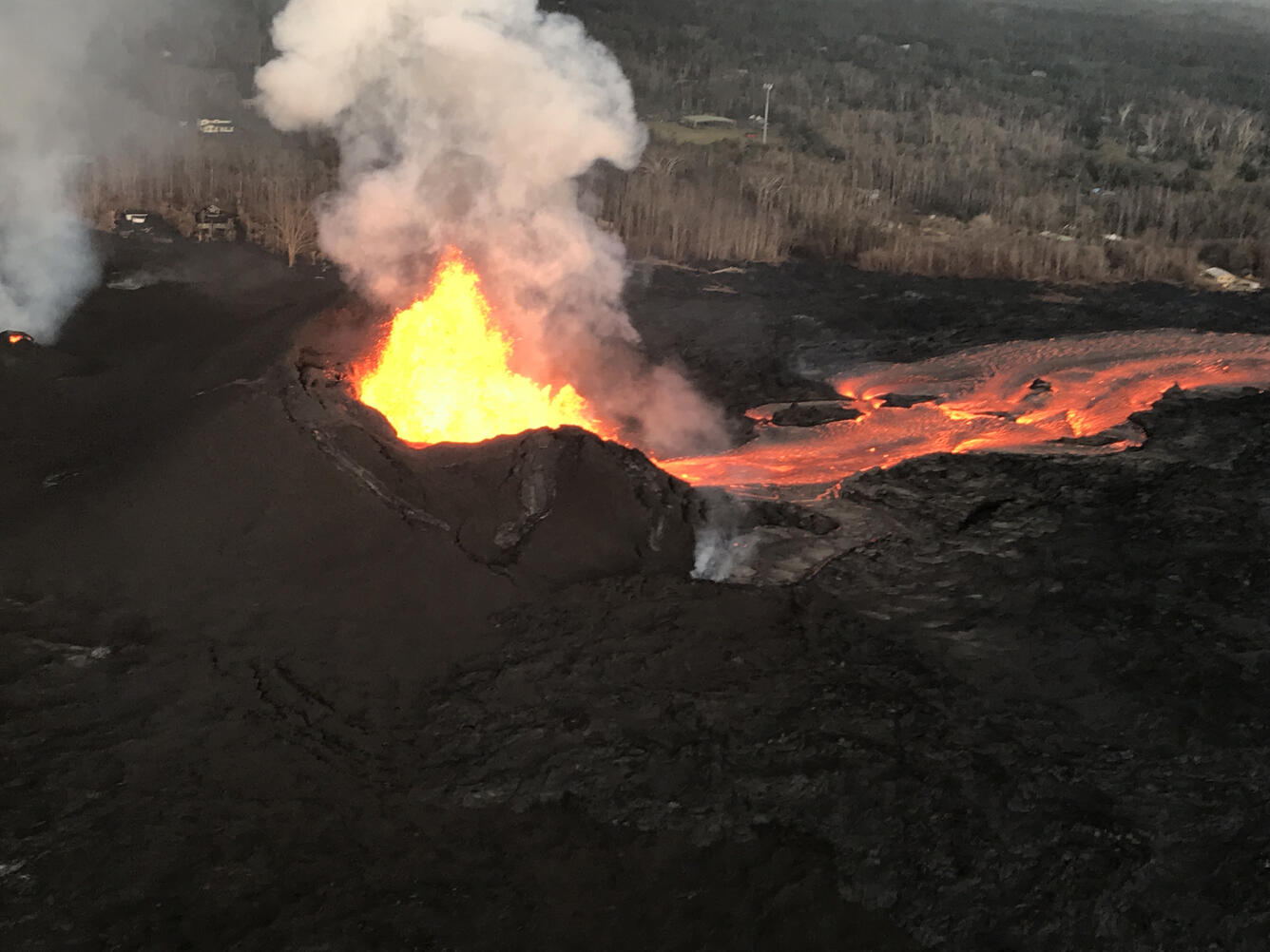
6/8/18, 10:49pm HST
Kīlauea Volcano Lower East Rift Zone
- Vigorous eruption of lava continues from the lower East Rift Zone (LERZ) fissure system in the area of Leilani Estates.
- Lava continues to erupt from Fissure 8, with vigorous fountains reaching heights of about 200-220 feet. Two vigorous steam plumes are rising from the ocean flow front and being blown inland. Strong thermal upwelling was noted in the ocean extending up to 1000 yards out to sea from the visible lava front. Heavy gas and steam emissions were noted at fissures 9 & 10, but lava emission is occurring only at Fissure 8.
Kīlauea Volcano Summit
- Low level ash emissions continue at the summit with slowly increasing seismicity, indicating that another small explosion is likely in the next several hours. Inward slumping of the rim and walls of Halema`uma`u continues in response to ongoing subsidence at the summit.
- Sulfur dioxide emissions from the volcano's summit, while lower than those recorded in early-mid May, remain high enough to impact air quality in downwind regions. Additional bursts of gas released with intermittent explosive activity are also transported downwind and may temporarily affect air quality as well.

6/8/18, 4:54pm HST
Kīlauea Volcano Lower East Rift Zone
- Vigorous eruption of lava continues from the lower East Rift Zone (LERZ) fissure system in the area of Leilani Estates.
- Lava eruption continued at Fissure 8 with vigorous fountains reaching heights of about 220 feet. Geology crews reported no significant changes in the Fissure 8 flow field and two large plumes at the broad ocean entry. The Kapoho Beachlots boundary has not changed since this morning's overflight. There is no lava activity from the other fissures.
- Following a magnitude-3.2 earthquake at the summit, twelve rockfalls were recorded in Puʻu ʻŌʻō between 10:31 and 10:56 AM with a prominent, but brief, red dust plume ejected into the air around 10:50 AM.
Kīlauea Volcano Summit
- Low level ash emissions continue and seismicity levels increase at the summit of Kilauea. Inward slumping of the rim and walls of Halema`uma`u continues in response to ongoing subsidence at the summit.
- Sulfur dioxide emissions from the volcano's summit, while lower than those recorded in early-mid May, remain high enough to impact air quality in downwind regions. Additional bursts of gas released with intermittent explosive activity are also transported downwind and may temporarily affect air quality as well.

UPDATE, 6/8/18, 8:25am HST
Kīlauea Volcano Lower East Rift Zone
Vigorous eruption of lava continues from the lower East Rift Zone (LERZ) fissure system in the area of Leilani Estates.
Overnight, lava fountaining at Fissure 8 continue to reach heights of about 220 feet. Geology and UAS crews observed no significant changes in the Fissure 8 flow field. HVO's morning overflight revealed. There is no lava activity from the other fissures but Fissure 24 is incandescent and Fissures 24, 9, and 10 are fuming heavily.
Pele's hair and other lightweight volcanic glass from high fountaining of Fissure 8 are falling downwind of the fissure and accumulating on the ground within Leilani Estates. High winds may waft lighter particles to greater distances. Residents are urged to minimize exposure to these volcanic particles, which can cause skin and eye irritation similar to volcanic ash.
The most recent map of lava flows can be found at https://volcanoes.usgs.gov/volcanoes/kilauea/multimedia_maps.html
HVO field crews are on site tracking the fountains, lava flows, and spattering from Fissure 8 as conditions allow and are reporting information to Hawaii County Civil Defense. Observations are also collected on a daily basis from cracks in the area of Highway 130; no changes in temperature, crack width, or gas emissions have been noted.
Volcanic gas emissions remain very high from Fissure 8 eruptions. For the next few days, easterly wind conditions may bring vog not only to the south and west sides of the Island of Hawaii, but also upslope to the island's interior.
The ocean entry is a hazardous area. Venturing too close to an ocean entry on land or the ocean exposes you to flying debris from sudden explosive interaction between lava and water. Also, the lava delta is unstable because it is built on unconsolidated lava fragments and sand. This loose material can easily be eroded away by surf, causing the new land to become unsupported and slide into the sea. Additionally, the interaction of lava with the ocean creates "laze", a corrosive seawater plume laden with hydrochloric acid and fine volcanic particles that can irritate the skin, eyes, and lungs.
Magma continues to be supplied to the lower East Rift Zone. Seismicity remains relatively low in the area with numerous small magnitude earthquakes and low amplitude background tremor. Higher amplitude tremor is occasionally being recorded on seismic stations close to the ocean entry.
Additional ground cracking and outbreaks of lava in the area of the active fissures are possible. Residents downslope of the region of fissures should heed all Hawaii County Civil Defense messages and warnings.
Kīlauea Volcano Summit
At 2:44 AM HST, a small explosion occurred at the summit of Kilauea. No weather radar observations of plume heights are possible, but satellite data suggest that any plume that might have been generated did not exceed 10,000 feet above sea level. Since the small explosion, seismic activity in the summit region has been low. Inward slumping of the rim and walls of Halema`uma`u continues in response to ongoing subsidence at the summit.
Sulfur dioxide emissions from the volcano's summit, while lower than those recorded in early-mid May, remain high enough to impact air quality in downwind regions. Additional bursts of gas released with intermittent explosive activity are also transported downwind and may temporarily affect air quality as well.
For forecasts of where ash would fall under forecast wind conditions, please consult the Ash3D model output here: https://volcanoes.usgs.gov/observatories/hvo/activity_2018.html
Information on volcanic ash hazards and how to prepare for ash fall maybe found at http://www.ivhhn.org/information#ash (health impacts) OR https://volcanoes.usgs.gov/volcanic_ash/ (other impacts).
UPDATE, 6/7/18, 10:22pm HST
Kīlauea Volcano Lower East Rift Zone
Vigorous eruption of lava continues from the lower East Rift Zone (LERZ) fissure system in the area of Leilani Estates.

Lava fountaining at Fissure 8 continues unabated with fountain tops reported between 170-200 feet. This activity continues to feed a lava channel flowing east towards the ocean entry in the Kapoho Bay area. Bad weather and poor visibility grounded the late afternoon overflight but ground observers confirm lava continues to enter the sea as of early evening.
No other fissures are active.
Pele's hair and other lightweight volcanic glass from high fountaining of Fissure 8 are falling downwind of the fissure and accumulating on the ground within Leilani Estates. High winds may waft lighter particles to greater distances. Residents are urged to minimize exposure to these volcanic particles, which can cause skin and eye irritation similar to volcanic ash.
The most recent map of lava flows can be found at https://volcanoes.usgs.gov/volcanoes/kilauea/multimedia_maps.html
HVO field crews are on site tracking the fountains, lava flows, and spattering from Fissure 8 as conditions allow and are reporting information to Hawaii County Civil Defense. Observations are also collected on a daily basis from cracks in the area of Highway 130; no changes in temperature, crack width, or gas emissions have been noted.
Volcanic gas emissions remain very high from Fissure 8 eruptions. For the next few days, easterly wind conditions may bring vog not only to the south and west sides of the Island of Hawaii, but also upslope to the island's interior.
The ocean entry is a hazardous area. Hazards include walking on uneven, glassy lava flow surfaces and around unstable, vertical sea cliffs. Venturing too close to an ocean entry on land or the ocean exposes you to flying debris from sudden explosive interaction between lava and water. Also, the lava delta is unstable because it is built on unconsolidated lava fragments and sand. This loose material can easily be eroded away by surf, causing the new land to become unsupported and slide into the sea. In several instances, such collapses have also incorporated parts of the older sea cliff. Additionally, the interaction of lava with the ocean creates "laze", a corrosive seawater plume laden with hydrochloric acid and fine volcanic particles that can irritate the skin, eyes, and lungs.
Magma continues to be supplied to the lower East Rift Zone. Earthquake locations have not moved farther downrift in the past few days and the number of located earthquakes remains low. Seismicity remains relatively low in the area with numerous small magnitude earthquakes and low amplitude background tremor. Higher amplitude tremor is being recorded on seismic stations close to the ocean entry.
Additional ground cracking and outbreaks of lava in the area of the active fissures are possible. Residents downslope of the region of fissures should heed all Hawaii County Civil Defense messages and warnings.
Kīlauea Volcano Summit
Seismic activity at the summit is increasing, with a few M3 events in the past several hours. Based on the pattern of previous days, we expect a small explosion to occur overnight. Inward slumping of the rim and walls of Halema`uma`u continues in response to ongoing subsidence at the summit.

Over the last week, sulfur dioxide emissions from the volcano's summit have decreased, but emission rates remain high enough to impact air quality in downwind regions. Additional bursts of gas released with intermittent explosive activity are also transported downwind and may temporarily affect air quality as well.
For forecasts of where ash would fall under forecast wind conditions, please consult the Ash3D model output here: https://volcanoes.usgs.gov/observatories/hvo/activity_2018.html
Information on volcanic ash hazards and how to prepare for ash fall maybe found at http://www.ivhhn.org/information#ash (health impacts) OR https://volcanoes.usgs.gov/volcanic_ash/ (other impacts).
For more information on how satellite imagery is being used to support the USGS eruption response, see the International Charter for Space and Major Disasters website.
UPDATE, 6/7//18, 4:24pm HST
Kīlauea Volcano Lower East Rift Zone
Vigorous eruption of lava continues from the lower East Rift Zone (LERZ) fissure system in the area of Leilani Estates.
Lava fountaining at Fissure 8 fluctuated with heights varying between 190 and 215 feet. This activity is feeding a lava channel flowing east to the ocean entry in the Kapoho Bay area. The noon overflight found that the delta is about 1.2 mi wide in the Vacationland/Waopae area and observed the flow was expanding northward through Kapoho Beachlots. A large area of upwelling offshore suggests the presence of lava flowing on the ocean floor in that area.
No other fissures are active.
Pele's hair and other lightweight volcanic glass from high fountaining of Fissure 8 are falling downwind of the fissure and accumulating on the ground within Leilani Estates. Winds may waft lighter particles to greater distances. Residents are urged to minimize exposure to these volcanic particles, which can cause skin and eye irritation similar to volcanic ash.
The most recent map of lava flows can be found at https://volcanoes.usgs.gov/volcanoes/kilauea/multimedia_maps.html
HVO field crews are on site tracking the fountains, lava flows, and spattering from Fissure 8 as conditions allow and are reporting information to Hawaii County Civil Defense. Observations are also collected on a daily basis from cracks in the area of Highway 130; no changes in temperature, crack width, or gas emissions have been noted.
Volcanic gas emissions remain very high from Fissure 8 eruptions. For the next few days, easterly wind conditions may bring vog not only to the south and west sides of the Island of Hawaii, but also upslope to the island's interior.
The ocean entry is a hazardous area. Hazards include walking on uneven, glassy lava flow surfaces and around unstable, vertical sea cliffs. Venturing too close to an ocean entry on land or the ocean exposes you to flying debris from sudden explosive interaction between lava and water. Also, the lava delta is unstable because it is built on unconsolidated lava fragments and sand. This loose material can easily be eroded away by surf, causing the new land to become unsupported and slide into the sea. In several instances, such collapses have also incorporated parts of the older sea cliff. Additionally, the interaction of lava with the ocean creates "laze", a corrosive seawater plume laden with hydrochloric acid and fine volcanic particles that can irritate the skin, eyes, and lungs.
Magma continues to be supplied to the lower East Rift Zone. Earthquake locations have not moved farther downrift in the past few days and the number of located earthquakes remains low. Seismicity remains relatively low with numerous small magnitude earthquakes and low amplitude background tremor.
Additional ground cracking and outbreaks of lava in the area of the active fissures are possible. Residents downslope of the region of fissures should heed all Hawaii County Civil Defense messages and warnings.
Kīlauea Volcano Summit
Seismic activity at the summit was increasing slowly after yesterday afternoon's small explosion. We anticipate an additional small explosion probably in about 24 hours. Inward slumping of the rim and walls of Halema`uma`u continues in response to ongoing subsidence of the summit.
Over the last week, sulfur dioxide emissions from the volcano's summit have decreased, but emission rates remain high enough to impact air quality in downwind regions. Additional bursts of gas released with intermittent explosive activity are also transported downwind and may temporarily affect air quality as well.
For forecasts of where ash would fall under forecast wind conditions, please consult the Ash3D model output here: https://volcanoes.usgs.gov/observatories/hvo/activity_2018.html
Information on volcanic ash hazards and how to prepare for ash fall maybe found at http://www.ivhhn.org/information#ash (health impacts) OR https://volcanoes.usgs.gov/volcanic_ash/ (other impacts).
For more information on how satellite imagery is being used to support the USGS eruption response, see the International Charter for Space and Major Disasters website.
UPDATE, 6/7/18, 8:50am HST
Kīlauea Volcano Lower East Rift Zone
Vigorous eruption of lava continues from the lower East Rift Zone (LERZ) fissure system in the area of Leilani Estates.
Overnight, lava fountaining at Fissure 8 fluctuated, reaching heights of 230 feet. This activity is feeding a lava channel flowing east to the Kapoho Bay area. Observations by HVO geologists and the University of Hawaii at Hilo UAS crew during the night indicated that the northern lobe of the Fissure 8 flow is not receiving significant lava, and the lobe that was active on the west side of the Four Corners cinder pit is inactive. The morning overflight confirmed these observations and revealed minor overflows from the channel. Lava is entering the ocean along a broad front in the general area of Kapoho Bay and Vacationland. Lava also continues to creep north through what remains of Kapoho Beach Lots.

No other fissures are active.
Pele's hair and other lightweight volcanic glass from high fountaining of Fissure 8 are falling downwind of the fissure and accumulating on the ground within Leilani Estates. Winds may waft lighter particles to greater distances. Residents are urged to minimize exposure to these volcanic particles, which can cause skin and eye irritation similar to volcanic ash.
The most recent map of lava flows can be found at https://volcanoes.usgs.gov/volcanoes/kilauea/multimedia_maps.html
HVO field crews are on site tracking the fountains, lava flows, and spattering from Fissure 8 as conditions allow and are reporting information to Hawaii County Civil Defense. Observations are also collected on a daily basis from cracks in the area of Highway 130; no changes in temperature, crack width, or gas emissions have been noted.
Volcanic gas emissions remain very high from Fissure 8 eruptions. For the next few days, easterly wind conditions may bring vog not only to the south and west sides of the Island of Hawaii, but also upslope to the island's interior.
The ocean entry is a hazardous area. Hazards include walking on uneven, glassy lava flow surfaces and around unstable, vertical sea cliffs. Venturing too close to an ocean entry on land or the ocean exposes you to flying debris from sudden explosive interaction between lava and water. Also, the lava delta is unstable because it is built on unconsolidated lava fragments and sand. This loose material can easily be eroded away by surf, causing the new land to become unsupported and slide into the sea. In several instances, such collapses have also incorporated parts of the older sea cliff. Additionally, the interaction of lava with the ocean creates "laze", a corrosive seawater plume laden with hydrochloric acid and fine volcanic particles that can irritate the skin, eyes, and lungs.
Magma continues to be supplied to the lower East Rift Zone. Earthquake locations have not moved farther downrift in the past few days and the number of located earthquakes remains low. Seismicity remains relatively low with numerous small magnitude earthquakes and low amplitude background tremor.
Additional ground cracking and outbreaks of lava in the area of the active fissures are possible. Residents downslope of the region of fissures should heed all Hawaii County Civil Defense messages and warnings.
Kīlauea Volcano Summit

Seismic activity at the summit was subdued overnight -- a natural consequence of yesterday afternoon's small explosion. Earthquake activity is on the rise, however, and we anticipate an additional small explosion probably in about 24 hours. Inward slumping of the rim and walls of Halema`uma`u continues in response to ongoing subsidence of the summit.
Over the last week, sulfur dioxide emissions from the volcano's summit have decreased, but emission rates remain high enough to impact air quality in downwind regions. Additional bursts of gas released with intermittent explosive activity are also transported downwind and may temporarily affect air quality as well.
For forecasts of where ash would fall under forecast wind conditions, please consult the Ash3D model output here: https://volcanoes.usgs.gov/observatories/hvo/activity_2018.html
Information on volcanic ash hazards and how to prepare for ash fall maybe found at http://www.ivhhn.org/information#ash (health impacts) OR https://volcanoes.usgs.gov/volcanic_ash/ (other impacts).
For more information on how satellite imagery is being used to support the USGS eruption response, see the International Charter for Space and Major Disasters website.
UPDATE, 6/6/18, 10:41pm HST
Kīlauea Volcano Lower East Rift Zone
Vigorous eruption of lava continues from the lower East Rift Zone (LERZ) fissure system in the area of Leilani Estates.
Lava fountaining at Fissure 8 continues, with fountain tops reaching heights of 130-210 feet, This activity is feeding a lava channel flowing east to the Kapoho Bay area. Lava is continuing to enter the ocean in the area of the Vacationland subdivision. A late afternoon overflight showed that the ocean entry is creating a vigorous steam plume that is being blown inland to the southwest. The delta that formed at Kapoho Bay extended slightly throughout the day, and a lateral lobe of the flow is pushing slowly north through what remains of the Kapaho Beach Lots subdivision.
The northern lobe of the Fissure 8 flow appears to have stalled with only traces of smoke at the flow front, although there is some incandescence in the finger of that lobe that advanced along a low graben a few nights ago. No other fissures are active.
Pele's hair and other lightweight volcanic glass from high fountaining of Fissure 8 are falling downwind of the fissure and accumulating on the ground within Leilani Estates. Winds may waft lighter particles to greater distances. Residents are urged to minimize exposure to these volcanic particles, which can cause skin and eye irritation similar to volcanic ash.
The most recent map of lava flows can be found at https://volcanoes.usgs.gov/volcanoes/kilauea/multimedia_maps.html
HVO field crews are on site tracking the fountains, lava flows, and spattering from multiple fissures as conditions allow and are reporting information to Hawaii County Civil Defense.
Volcanic gas emissions remain very high from the fissure eruptions. For the next few days wind conditions may bring vog not only to the south and west sides of the Island of Hawaii, but also the island's interior.

The ocean entry is a hazardous area. Hazards include walking on uneven, glassy lava flow surfaces and around unstable, vertical sea cliffs. Venturing too close to an ocean entry on land or the ocean exposes you to flying debris from sudden explosive interaction between lava and water. Also, the lava delta is unstable because it is built on unconsolidated lava fragments and sand. This loose material can easily be eroded away by surf, causing the new land to become unsupported and slide into the sea. In several instances, such collapses have also incorporated parts of the older sea cliff. Additionally, the interaction of lava with the ocean creates "laze", a corrosive seawater plume laden with hydrochloric acid and fine volcanic particles that can irritate the skin, eyes, and lungs.
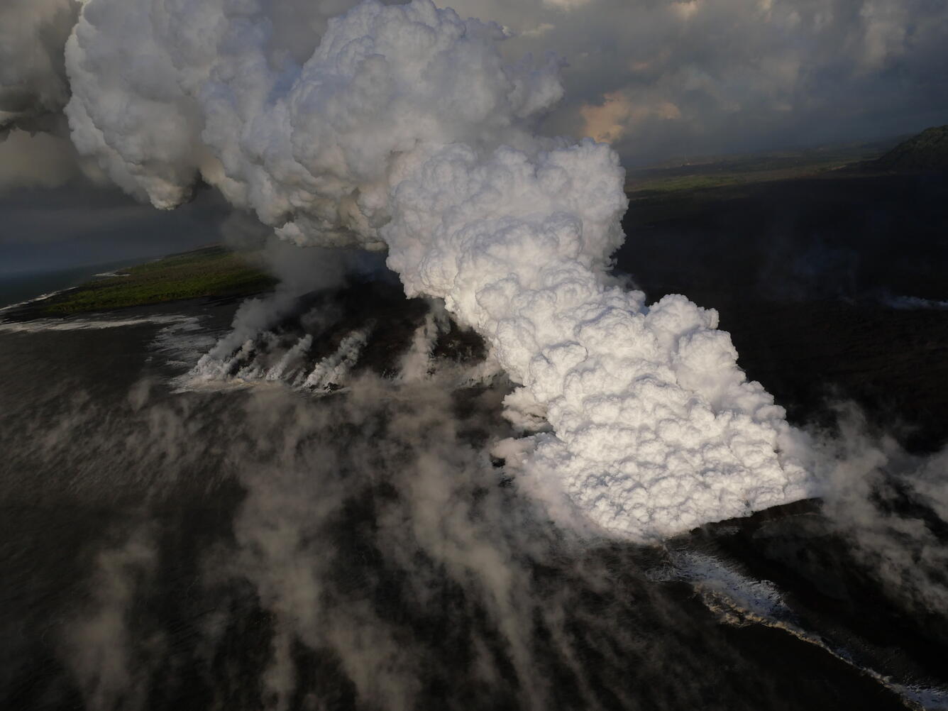
Magma continues to be supplied to the lower East Rift Zone. Earthquake locations have not moved farther downrift in the past few days and the number of located earthquakes remains low. Seismicity remains relatively low with numerous small magnitude earthquakes and low amplitude background tremor.
Additional ground cracking and outbreaks of lava in the area of the active fissures are possible. Residents downslope of the region of fissures should heed all Hawaii County Civil Defense messages and warnings.
Kīlauea Volcano Summit
A small explosion, with an equivalent earthquake magnitude of M5.6, occurred at 4.07 PM HST, generating an ash plume that rose to an elevation of about 10,000 feet. Since this small explosion, summit seismicity has dropped significantly, following the pattern of previous events. Inward slumping of the rim and walls of Halema`uma`u continues in response to ongoing subsidence of the summit.
Over the last week, sulfur dioxide emissions from the volcano's summit have decreased, but emission rates remain high enough to impact air quality in downwind regions. Additional bursts of gas released with intermittent explosive activity are also transported downwind and may temporarily affect air quality as well.
For forecasts of where ash would fall under forecast wind conditions, please consult the Ash3D model output here: https://volcanoes.usgs.gov/observatories/hvo/activity_2018.html
Information on volcanic ash hazards and how to prepare for ash fall maybe found at http://www.ivhhn.org/information#ash (health impacts) OR https://volcanoes.usgs.gov/volcanic_ash/ (other impacts).
MORE INFORMATION
Activity Summary also available by phone: (808) 967-8862
Subscribe to these messages: https://volcanoes.usgs.gov/vns2/
Webcam images: https://volcanoes.usgs.gov/volcanoes/kilauea/multimedia_webcams.html
Photos/Video: https://volcanoes.usgs.gov/volcanoes/kilauea/multimedia_chronology.html
Lava Flow Maps: https://volcanoes.usgs.gov/volcanoes/kilauea/multimedia_maps.html
Definitions of terms used in update: https://volcanoes.usgs.gov/volcanoes/kilauea/extra/definitions.pdf
Overview of Kīlauea summit (Halemaʻumaʻu) and East Rift Zone (Puʻu ʻŌʻō ) eruptions:
https://volcanoes.usgs.gov/volcanoes/kilauea/extra/background.pdf
Summary of volcanic hazards from Kīlauea eruptions:
https://volcanoes.usgs.gov/volcanoes/kilauea/extra/hazards.pdf
Recent Earthquakes in Hawai'i (map and list):
https://volcanoes.usgs.gov/hvo/earthquakes/
Explanation of Volcano Alert Levels and Aviation Color Codes:
https://volcanoes.usgs.gov/activity/alertsystem/index.php
https://pubs.usgs.gov/fs/2006/3139/
For more information on how satellite imagery is being used to support the USGS eruption response, see the International Charter for Space and Major Disasters website.
CONTACT INFORMATION:
askHVO@usgs.gov
The Hawaiian Volcano Observatory is one of five volcano observatories within the U.S. Geological Survey and is responsible for monitoring volcanoes and earthquakes in Hawai`i.
UPDATE, 6/6/18, 2:34pm HST
Kīlauea Volcano Lower East Rift Zone
Vigorous eruption of lava continues from the lower East Rift Zone (LERZ) fissure system in the area of Leilani Estates.
This morning, lava fountaining at Fissure 8 continued to reach heights of 150-180 feet, feeding a stable channel to the east to the ocean entry in the Kapoho Bay area. Lava is entering the ocean in the Vacationland subdivision. Vacationland has been completely covered by lava, and overnight the flow expanded north by 100 m within Kapoho Beach Lots. The lava delta that formed at Kapoho Bay extended slightly overnight.

The northern lobe of the Fissure 8 flow shows no signs of activity this morning, and there is only wispy smoke at the flow front. No other fissures are active.
Pele's hair and other lightweight volcanic glass from high fountaining of Fissure 8 are falling downwind of the fissure and accumulating on the ground within Leilani Estates. Winds may waft lighter particles to greater distances. Residents are urged to minimize exposure to these volcanic particles, which can cause skin and eye irritation similar to volcanic ash.
The most recent map of lava flows can be found at https://volcanoes.usgs.gov/volcanoes/kilauea/multimedia_maps.html
HVO field crews are on site tracking the fountains, lava flows, and spattering from multiple fissures as conditions allow and are reporting information to Hawaii County Civil Defense.
Volcanic gas emissions remain very high from the fissure eruptions. For the next few days wind conditions may bring vog not only to the south and west sides of the Island of Hawaii, but also the island's interior.
The ocean entry is a hazardous area. Hazards include walking on uneven, glassy lava flow surfaces and around unstable, vertical sea cliffs. Venturing too close to an ocean entry on land or the ocean exposes you to flying debris from sudden explosive interaction between lava and water. Also, the lava delta is unstable because it is built on unconsolidated lava fragments and sand. This loose material can easily be eroded away by surf, causing the new land to become unsupported and slide into the sea. In several instances, such collapses have also incorporated parts of the older sea cliff. Additionally, the interaction of lava with the ocean creates "laze", a corrosive seawater plume laden with hydrochloric acid and fine volcanic particles that can irritate the skin, eyes, and lungs.
Magma continues to be supplied to the lower East Rift Zone. Earthquake locations have not moved farther downrift in the past few days and the number of located earthquakes remains low. Seismicity remains relatively low with numerous small magnitude earthquakes and low amplitude background tremor.
Additional ground cracking and outbreaks of lava in the area of the active fissures are possible. Residents downslope of the region of fissures should heed all Hawaii County Civil Defense messages and warnings.
Kīlauea Volcano Summit
Earthquake activity is increasing after Tuesday morning's small explosion, with ten M3+ earthquakes since 5 am in the Kīlauea summit area. This pattern suggests that more felt earthquakes and a small explosion are likely within the next few hours. Monitoring data indicate that subsidence at the summit and inward slumping of the rim and walls of Halema`uma`u continues.
Over the last week, sulfur dioxide emissions from the volcano's summit have decreased, but emission rates remain high enough to impact air quality in downwind regions. Additional bursts of gas released with intermittent explosive activity are also transported downwind and may temporarily affect air quality as well.
For forecasts of where ash would fall under forecast wind conditions, please consult the Ash3D model output here: https://volcanoes.usgs.gov/observatories/hvo/activity_2018.html
Information on volcanic ash hazards and how to prepare for ash fall maybe found at http://www.ivhhn.org/information#ash (health impacts) OR https://volcanoes.usgs.gov/volcanic_ash/ (other impacts).
For more information on how satellite imagery is being used to support the USGS eruption response, see the International Charter for Space and Major Disasters website.
UPDATE, 6/5/18, 10:28pm HST
Kīlauea Volcano Lower East Rift Zone
Vigorous eruption of lava continues from the lower East Rift Zone (LERZ) fissure system in the area of Leilani Estates and Lanipuna Gardens.
Persistent lava fountaining at Fissure 8 is reaching heights of 150-180 feet. This eruptive activity continues to feed a channel transporting lava to the east to the ocean entry in the Kapoho Bay area. Minor breakouts along the channelized flow have been very small and stagnated before travelling any significant distance. HVO's late afternoon overflight showed that the Fissure 8 flow is continuing to form a lava delta with limited continuing advances into the surviving parts of the Kaphoho Beach Lots and Vacationlands neighborhoods. The northernmost lobe of the Fissure 8 flow is advancing very slowly to the northeast. No other fissure vents are active.
Pele's hair and other lightweight volcanic glass from high fountaining of Fissure 8 are falling downwind of the fissure and accumulating on the ground within Leilani Estates. Winds may waft lighter particles to greater distances. Residents are urged to minimize exposure to these volcanic particles, which can cause skin and eye irritation similar to volcanic ash.
The most recent map of lava flows can be found at https://volcanoes.usgs.gov/volcanoes/kilauea/multimedia_maps.html
HVO field crews are on site tracking the fountains, lava flows, and spattering from multiple fissures as conditions allow and are reporting information to Hawaii County Civil Defense.
Volcanic gas emissions remain very high from the fissure eruptions. Trade wind conditions are bringing vog to the south and west sides of the Island of Hawaii. Afternoon easterly winds may bring vog to communities in the Volcano area.
The ocean entry is a hazardous area. Hazards include walking on uneven, glassy lava flow surfaces and around unstable, vertical sea cliffs. Venturing too close to an ocean entry on land or the ocean exposes you to flying debris from sudden explosive interaction between lava and water. Also, the lava delta is unstable because it is built on unconsolidated lava fragments and sand. This loose material can easily be eroded away by surf, causing the new land to become unsupported and slide into the sea. In several instances, such collapses have also incorporated parts of the older sea cliff. Additionally, the interaction of lava with the ocean creates "laze", a corrosive seawater plume laden with hydrochloric acid and fine volcanic particles that can irritate the skin, eyes, and lungs.
Magma continues to be supplied to the lower East Rift Zone. Earthquake locations have not moved farther downrift in the past few days and the number of located earthquakes remains low. Seismicity remains relatively low with numerous small magnitude earthquakes and low amplitude background tremor.
Additional ground cracking and outbreaks of lava in the area of the active fissures are possible. Residents downslope of the region of fissures should heed all Hawaii County Civil Defense messages and warnings.
Kīlauea Volcano Summit
Earthquake activity dropped after Tuesday morning's small explosion but is slowly rising now, following the pattern of previous events of this type. Monitoring data indicate that subsidence at the summit continues. The mid-day observation flight showed additional Inward slumping of the rim and walls of Halema`uma`u.

Locally felt earthquakes are expected to continue, and further ash explosions are likely.
Over the last week, sulfur dioxide emissions from the volcano's summit have decreased, but emission rates remain high enough to impact air quality in downwind regions. Additional bursts of gas released with intermittent explosive activity are also transported downwind and may temporarily affect air quality as well.
For forecasts of where ash would fall under forecast wind conditions, please consult the Ash3D model output here: https://volcanoes.usgs.gov/observatories/hvo/activity_2018.html
Information on volcanic ash hazards and how to prepare for ash fall maybe found at http://www.ivhhn.org/information#ash (health impacts) OR https://volcanoes.usgs.gov/volcanic_ash/ (other impacts).
For more information on how satellite imagery is being used to support the USGS eruption response, see the International Charter for Space and Major Disasters website.
UPDATE, 6/5/18, 4:54pm HST
Kīlauea Volcano Lower East Rift Zone
Vigorous eruption of lava continues from the lower East Rift Zone (LERZ) fissure system in the area of Leilani Estates and Lanipuna Gardens.

Lava fountaining at Fissure 8 is continuing with fountain heights reported at 150-180 feet. This eruptive activity continues to feed a channel transporting lava to the northeast along Highway 132 and east to the ocean entry in Kapoho Bay area. Minor breakouts along the channelized flow field continue to occur but all have been very small and have stagnated before travelling any significant distance. HVO's mid-day overflight showed the fissure 8 flow has completely filled Kapoho Bay and formed a lava delta extending 0.8 miles out from the former coastline. The northernmost lobe of the Fissure 8 flow, in the Noni Farms Road area, is advancing very slowly to the northeast. No other fissure vents showed significant activity at this time.
Pele's hair and other lightweight volcanic glass from high fountaining of Fissure 8 are falling downwind of the fissure and accumulating on the ground within Leilani Estates. Winds may waft lighter particles to greater distances. Residents are urged to minimize exposure to these volcanic particles, which can cause skin and eye irritation similar to volcanic ash.
The most recent map of lava flows can be found at https://volcanoes.usgs.gov/volcanoes/kilauea/multimedia_maps.html
HVO field crews are on site tracking the fountains, lava flows, and spattering from multiple fissures as conditions allow and are reporting information to Hawaii County Civil Defense.
Volcanic gas emissions remain very high from the fissure eruptions. Trade wind conditions are bringing vog to the south and west sides of the Island of Hawaii. Afternoon easterly winds may bring vog to communities in the Volcano area.
The ocean entry is a hazardous area. Hazards include walking on uneven, glassy lava flow surfaces and around unstable, vertical sea cliffs. Venturing too close to an ocean entry on land or the ocean exposes you to flying debris from sudden explosive interaction between lava and water. Also, the lava delta is unstable because it is built on unconsolidated lava fragments and sand. This loose material can easily be eroded away by surf, causing the new land to become unsupported and slide into the sea. In several instances, such collapses have also incorporated parts of the older sea cliff. Additionally, the interaction of lava with the ocean creates "laze", a corrosive seawater plume laden with hydrochloric acid and fine volcanic particles that can irritate the skin, eyes, and lungs.
Magma continues to be supplied to the lower East Rift Zone. Earthquake locations have not moved farther downrift in the past few days and the number of located earthquakes remains low. Seismicity remains relatively low with numerous small magnitude earthquakes and low amplitude background tremor.
Additional ground cracking and outbreaks of lava in the area of the active fissures are possible. Residents downslope of the region of fissures should heed all Hawaii County Civil Defense messages and warnings.
Kīlauea Volcano Summit
Earthquake activity dropped after this morning's small explosion and is now slowly rising following the pattern of previous events of this type. Monitoring data show that subsidence at the summit crater continues. The mid-day observation flight showed continued Inward slumping of the rim and walls of Halema`uma`u in response to subsidence at the summit.
Locally felt earthquakes are expected to continue and further ash explosions are likely.
Over the last week, sulfur dioxide passively degassing from the volcano's summit has decreased, but emission rates remain high enough to impact air quality in downwind regions. Additional bursts of gas released with intermittent explosive activity are also transported downwind and may temporarily affect air quality as well.
For forecasts of where ash would fall under forecast wind conditions, please consult the Ash3D model output here: https://volcanoes.usgs.gov/observatories/hvo/activity_2018.html
Information on volcanic ash hazards and how to prepare for ash fall maybe found at http://www.ivhhn.org/information#ash (health impacts) OR https://volcanoes.usgs.gov/volcanic_ash/ (other impacts).
For more information on how satellite imagery is being used to support the USGS eruption response, see the International Charter for Space and Major Disasters website.
UPDATE, 6/5/18, 8:10pm HST
Kīlauea Volcano Lower East Rift Zone
Vigorous eruption of lava continues from the lower East Rift Zone (LERZ) fissure system in the area of Leilani Estates and Lanipuna Gardens.
The intensity of lava fountaining at Fissure 8 declined overnight, and fountain height is fluctuating between 130 and 160 feet (not far above the top of the cone that has formed over the past week). Fissure 8 continues to feed a channel transporting lava to the northeast along Highway 132 and east to the ocean entry in Kapoho Bay.
HVO's 6:30am HST overflight confirmed that lava completely fills Kapoho Bay, extending 0.7 miles from the former coastline. To the south, lava is entering the water at the Vacationland tidepools, having inundated most of that subdivision. To the north, lava has covered all but the northern part of Kapoho Beach Lots. The northernmost lobe of the Fissure 8 flow, in the Noni Farms Road area, advanced downslope about 200 yards overnight.
No other fissure vents showed significant activity this morning.
Pele's hair and other lightweight volcanic glass from high fountaining of Fissure 8 are falling downwind of the fissure and accumulating on the ground within Leilani Estates. Winds may waft lighter particles to greater distances. Residents are urged to minimize exposure to these volcanic particles, which can cause skin and eye irritation similar to volcanic ash.
The most recent map of lava flows can be found at https://volcanoes.usgs.gov/volcanoes/kilauea/multimedia_maps.html
HVO field crews are on site tracking the fountains, lava flows, and spattering from multiple fissures as conditions allow and are reporting information to Hawaii County Civil Defense.
Volcanic gas emissions remain very high from the fissure eruptions. Trade wind conditions are bringing vog to the south and west sides of the Island of Hawaii. Afternoon easterly winds may bring vog to communities in the Volcano area.
The ocean entry is a hazardous area. Hazards include walking on uneven, glassy lava flow surfaces and around unstable, vertical sea cliffs. Venturing too close to an ocean entry on land or the ocean exposes you to flying debris from sudden explosive interaction between lava and water. Also, the lava delta is unstable because it is built on unconsolidated lava fragments and sand. This loose material can easily be eroded away by surf, causing the new land to become unsupported and slide into the sea. In several instances, such collapses have also incorporated parts of the older sea cliff. Additionally, the interaction of lava with the ocean creates "laze", a corrosive seawater plume laden with hydrochloric acid and fine volcanic particles that can irritate the skin, eyes, and lungs.

Magma continues to be supplied to the lower East Rift Zone. Earthquake locations have not moved farther downrift in the past few days and the number of located earthquakes remains low. Seismicity remains relatively low with numerous small magnitude earthquakes and low amplitude background tremor.
Additional ground cracking and outbreaks of lava in the area of the active fissures are possible. Residents downslope of the region of fissures should heed all Hawaii County Civil Defense messages and warnings.
Kīlauea Volcano Summit
High levels of earthquake activity occurred for most of Monday night and into Tuesday morning. A small explosion, with an equivalent earthquake magnitude of M5.5, occurred at 4:32amHST, generating a small plume that rose about 1000 feet above the summit. Since the small explosion, summit seismicity has been low, following the pattern of previous events. Inward slumping of the rim and walls of Halema`uma`u continues in response to ongoing subsidence of the summit.
Locally felt earthquakes are expected to continue and further ash explosions are likely.
Over the last week, sulfur dioxide passively degassing from the volcano's summit has decreased, but emission rates remain high enough to impact air quality in downwind regions. Additional bursts of gas released with intermittent explosive activity are also transported downwind and may temporarily affect air quality as well.
For forecasts of where ash would fall under forecast wind conditions, please consult the Ash3D model output here: https://volcanoes.usgs.gov/observatories/hvo/activity_2018.html
Information on volcanic ash hazards and how to prepare for ash fall maybe found at http://www.ivhhn.org/information#ash (health impacts) OR https://volcanoes.usgs.gov/volcanic_ash/ (other impacts).
For more information on how satellite imagery is being used to support the USGS eruption response, see the International Charter for Space and Major Disasters website.
MORE INFORMATION
Activity Summary also available by phone: (808) 967-8862
Subscribe to these messages: https://volcanoes.usgs.gov/vns2/
Webcam images: https://volcanoes.usgs.gov/volcanoes/kilauea/multimedia_webcams.html
Photos/Video: https://volcanoes.usgs.gov/volcanoes/kilauea/multimedia_chronology.html
Lava Flow Maps: https://volcanoes.usgs.gov/volcanoes/kilauea/multimedia_maps.html
Definitions of terms used in update: https://volcanoes.usgs.gov/volcanoes/kilauea/extra/definitions.pdf
Overview of Kīlauea summit (Halemaʻumaʻu) and East Rift Zone (Puʻu ʻŌʻō ) eruptions:
https://volcanoes.usgs.gov/volcanoes/kilauea/extra/background.pdf
Summary of volcanic hazards from Kīlauea eruptions:
https://volcanoes.usgs.gov/volcanoes/kilauea/extra/hazards.pdf
Recent Earthquakes in Hawai'i (map and list):
https://volcanoes.usgs.gov/hvo/earthquakes/
Explanation of Volcano Alert Levels and Aviation Color Codes:
https://volcanoes.usgs.gov/activity/alertsystem/index.php
https://pubs.usgs.gov/fs/2006/3139/
CONTACT INFORMATION:
askHVO@usgs.gov
The Hawaiian Volcano Observatory is one of five volcano observatories within the U.S. Geological Survey and is responsible for monitoring volcanoes and earthquakes in Hawai`i.
UPDATE, 6/4/18, 10:21pm HST
Kīlauea Volcano Lower East Rift Zone
Vigorous eruption of lava continues from the lower East Rift Zone (LERZ) fissure system in the area of Leilani Estates and Lanipuna Gardens.
Fountaining at Fissure 8 continues to feed a robust channel transporting lava to the northeast along Highway 132 and east to the ocean entry in Kapoho Bay. Multiple observations from field crews and overflights suggest the Fissure 8 fountain is less vigorous this evening, with maximum heights of 130-160 feet. As of early evening, lava was filling Kapoho Bay, extending out approximately 750 yards from shore. A laze plume is blowing inland from the ocean entry but is dissipating quickly. The lava breakout on the north side of the Kapoho cinder pits continues to be stalled southeast of the intersection of Railroad Avenue and Cinder Road. A lava breakout from the south margin of the flow near the intersection of Highway 132 and Railroad Avenue has completely encircled the Green Lake cone.

Sluggish lava flows are present in the vicinity of Fissure 18, and there are reports of spattering at Fissures 6/13. All other fissures are inactive.
Pele's hair and other lightweight volcanic glass from high fountaining of Fissure 8 are falling downwind of the fissure and accumulating on the ground within Leilani Estates. Winds may waft lighter particles to greater distances. Residents are urged to minimize exposure to these volcanic particles, which can cause skin and eye irritation similar to volcanic ash.
The most recent map of lava flows can be found at https://volcanoes.usgs.gov/volcanoes/kilauea/multimedia_maps.html
HVO field crews are on site tracking the fountains, lava flows, and spattering from multiple fissures as conditions allow and are reporting information to Hawaii County Civil Defense.
Volcanic gas emissions remain very high from the fissure eruptions. Trade wind conditions are bringing vog to the south and west sides of the Island of Hawaii. Afternoon easterly winds may bring vog to communities in the Volcano area.
The ocean entry is a hazardous area. Hazards include walking on uneven, glassy lava flow surfaces and around unstable, vertical sea cliffs. Venturing too close to an ocean entry on land or the ocean exposes you to flying debris from sudden explosive interaction between lava and water. Also, the lava delta is unstable because it is built on unconsolidated lava fragments and sand. This loose material can easily be eroded away by surf, causing the new land to become unsupported and slide into the sea. In several instances, such collapses have also incorporated parts of the older sea cliff. Additionally, the interaction of lava with the ocean creates "laze", a corrosive seawater plume laden with hydrochloric acid and fine volcanic particles that can irritate the skin, eyes, and lungs.
Magma continues to be supplied to the lower East Rift Zone. Earthquake locations have not moved farther downrift in the past few days and the number of located earthquakes remains low. Seismicity remains relatively low with numerous small magnitude earthquakes and low amplitude background tremor.
Additional ground cracking and outbreaks of lava in the area of the active fissures are possible. Residents downslope of the region of fissures should heed all Hawaii County Civil Defense messages and warnings.
USGS Infographic: Kilauea

Kīlauea Volcano Summit
Earthquake activity at the summit was low after Sunday's small explosion, but has slowly increased since that time. Levels are approaching those of Sunday early afternoon, before the most recent small explosion. Inward slumping of the rim and walls of Halema`uma`u continues in response to persistent subsidence. We expect that earthquake rates will increase in the coming hours and culminate in another small explosion, perhaps within the next day, following the pattern of the past few weeks.
Over the last week, sulfur dioxide passively degassing from the volcano's summit has decreased, but emission rates remain high enough to impact air quality in downwind regions. Additional bursts of gas released with intermittent explosive activity are also transported downwind and may temporarily affect air quality as well.
For forecasts of where ash would fall under forecast wind conditions, please consult the Ash3D model output here: https://volcanoes.usgs.gov/observatories/hvo/activity_2018.html
Information on volcanic ash hazards and how to prepare for ash fall maybe found at http://www.ivhhn.org/information#ash (health impacts) OR https://volcanoes.usgs.gov/volcanic_ash/ (other impacts).
For more information on how satellite imagery is being used to support the USGS eruption response, see the International Charter for Space and Major Disasters website.
UPDATE, 6/4/18, 5:30pm HST
Kīlauea Volcano Lower East Rift Zone
Vigorous eruption of lava continues from the lower East Rift Zone (LERZ) fissure system in the area of Leilani Estates and Lanipuna Gardens.
Fountaining at Fissure 8 continued feeding a robust lava channel to northeast along Highway 132 to the ocean entry in Kapoho bay. As of late afternoon the lava entry had built a delta extending approximately 700 yards into the bay. A laze plume is blowing inland from the ocean entry but dissipating quickly. The lava flow front is about 600 yds wide. A lava breakout was also occurring upslope of the Kapoho cone cinder pit but stalled about 300 yards southeast of the intersection of Railroad Avenue and Cinder Road.
Sluggish lava flows are present in the vicinity of Fissure 18; all other fissures are inactive.
Pele's hair and other lightweight volcanic glass from high fountaining of Fissure 8 are falling downwind of the fissure and accumulating on the ground within Leilani Estates. Winds may waft lighter particles to greater distances. Residents are urged to minimize exposure to these volcanic particles, which can cause skin and eye irritation similar to volcanic ash.
The most recent map of lava flows can be found at https://volcanoes.usgs.gov/volcanoes/kilauea/multimedia_maps.html
HVO field crews are on site tracking the fountains, lava flows, and spattering from multiple fissures as conditions allow and are reporting information to Hawaii County Civil Defense.
Volcanic gas emissions remain very high from the fissure eruptions. Trade wind conditions are bringing vog to the south and west sides of the Island of Hawaii. Afternoon easterly winds may bring vog to communities in the Volcano area.
The ocean entry is a hazardous area. Hazards include walking on uneven, glassy lava flow surfaces and around unstable, vertical sea cliffs. Venturing too close to an ocean entry on land or the ocean exposes you to flying debris from sudden explosive interaction between lava and water. Also, the lava delta is unstable because it is built on unconsolidated lava fragments and sand. This loose material can easily be eroded away by surf, causing the new land to become unsupported and slide into the sea. In several instances, such collapses have also incorporated parts of the older sea cliff. Additionally, the interaction of lava with the ocean creates "laze", a corrosive seawater plume laden with hydrochloric acid and fine volcanic particles that can irritate the skin, eyes, and lungs.

Magma continues to be supplied to the lower East Rift Zone. Earthquake locations have not moved farther downrift in the past few days and the number of located earthquakes remains low. Seismicity remains relatively low with numerous small magnitude earthquakes and low amplitude background tremor.
Additional ground cracking and outbreaks of lava in the area of the active fissures are possible. Residents downslope of the region of fissures should heed all Hawaii County Civil Defense messages and warnings.
Kīlauea Volcano Summit
Earthquake activity at the summit has been low after the explosive eruption yesterday, but is slowly increasing. Inward slumping of the rim and walls of Halema`uma`u continues in response to persistent subsidence. We expect that earthquake rates may increase in the coming hours to days and culminate in another small explosion, following the pattern of the past few weeks.
Over the last week, sulfur dioxide passively degassing from the volcano's summit has decreased, but emission rates remain high enough to impact air quality in downwind regions. Additional bursts of gas released with intermittent explosive activity are also transported downwind and may temporarily affect air quality as well.
For forecasts of where ash would fall under forecast wind conditions, please consult the Ash3D model output here: https://volcanoes.usgs.gov/observatories/hvo/activity_2018.html
Information on volcanic ash hazards and how to prepare for ash fall maybe found at http://www.ivhhn.org/information#ash (health impacts) OR https://volcanoes.usgs.gov/volcanic_ash/ (other impacts).
MORE INFORMATION
Activity Summary also available by phone: (808) 967-8862
Subscribe to these messages: https://volcanoes.usgs.gov/vns2/
Webcam images: https://volcanoes.usgs.gov/volcanoes/kilauea/multimedia_webcams.html
Photos/Video: https://volcanoes.usgs.gov/volcanoes/kilauea/multimedia_chronology.html
Lava Flow Maps: https://volcanoes.usgs.gov/volcanoes/kilauea/multimedia_maps.html
Definitions of terms used in update: https://volcanoes.usgs.gov/volcanoes/kilauea/extra/definitions.pdf
Overview of Kīlauea summit (Halemaʻumaʻu) and East Rift Zone (Puʻu ʻŌʻō ) eruptions:
https://volcanoes.usgs.gov/volcanoes/kilauea/extra/background.pdf
Summary of volcanic hazards from Kīlauea eruptions:
https://volcanoes.usgs.gov/volcanoes/kilauea/extra/hazards.pdf
Recent Earthquakes in Hawai'i (map and list):
https://volcanoes.usgs.gov/hvo/earthquakes/
Explanation of Volcano Alert Levels and Aviation Color Codes:
https://volcanoes.usgs.gov/activity/alertsystem/index.php
https://pubs.usgs.gov/fs/2006/3139/
For more information on how satellite imagery is being used to support the USGS eruption response, see the International Charter for Space and Major Disasters website.
CONTACT INFORMATION:
askHVO@usgs.gov
The Hawaiian Volcano Observatory is one of five volcano observatories within the U.S. Geological Survey and is responsible for monitoring volcanoes and earthquakes in Hawai`i.
UPDATE, 6/4/18, 8:39am HST
Kīlauea Volcano Lower East Rift Zone
Vigorous eruption of lava continues from the lower East Rift Zone (LERZ) fissure system in the area of Leilani Estates and Lanipuna Gardens.
Fountaining at Fissure 8 continued overnight, feeding a robust lava channel to northeast along Highway 132 to the Kapoho area. Local videographers reported that lava entered the ocean at Kapoho Bay at about 10:30 PM HST on June 3. As of 6:30 AM on June 4, lava is constructing a delta in Kapoho Bay extending a few hundred yards into the bay. A laze plume is blowing inland from the ocean entry but dissipating quickly. The lava flow front is about 0.5 miles wide. A lava breakout is also occurring upslope of the Kapoho cone cinder pit, with active flows about 330 yards southeast of the intersection of Railroad Avenue and Cinder Road.
Sluggish lava flows are present in the vicinity of Fissure 18; all other fissures are inactive.
Pele's hair and other lightweight volcanic glass from high fountaining of Fissure 8 are falling downwind of the fissure and accumulating on the ground within Leilani Estates. Winds may waft lighter particles to greater distances. Residents are urged to minimize exposure to these volcanic particles, which can cause skin and eye irritation similar to volcanic ash.
The most recent map of lava flows can be found at https://volcanoes.usgs.gov/volcanoes/kilauea/multimedia_maps.html
HVO field crews are on site tracking the fountains, lava flows, and spattering from multiple fissures as conditions allow and are reporting information to Hawaii County Civil Defense.
Volcanic gas emissions remain very high from the fissure eruptions. Trade wind conditions are bringing vog to the south and west sides of the Island of Hawaii. Afternoon easterly winds may bring vog to communities in the Volcano area.
Magma continues to be supplied to the lower East Rift Zone. Earthquake locations have not moved farther downrift in the past few days and the number of located earthquakes remains low. Seismicity remains relatively low with numerous small magnitude earthquakes and low amplitude background tremor.
Kīlauea Volcano Summit
Following the small explosion at about 3:50 PM HST on June 3, earthquake activity at the summit has been low. Inward slumping of the rim and walls of Halema`uma`u continues in response to persistent subsidence. We expect that earthquake rates may increase in the coming hours to days and culminate in another small explosion, following the pattern of the past few weeks.
Volcanic gas emissions at the summit remain high.
For forecasts of where ash would fall under forecast wind conditions, please consult the Ash3D model output here: https://volcanoes.usgs.gov/observatories/hvo/activity_2018.html
Information on volcanic ash hazards and how to prepare for ash fall maybe found at http://www.ivhhn.org/information#ash (health impacts) OR https://volcanoes.usgs.gov/volcanic_ash/ (other impacts).
For more information on how satellite imagery is being used to support the USGS eruption response, see the International Charter for Space and Major Disasters website.
UPDATE, 6/3/18, 7:07pm HST
Kīlauea Volcano Lower East Rift Zone
Vigorous eruption of lava continues from the lower East Rift Zone (LERZ) fissure system in the area of Leilani Estates and Lanipuna Gardens.
Fissure 8 fountaining persisted throughout the day to heights up to 220 feet, and the channelized flow continued to deliver lava northeast along Highway 132 to the Kapoho area. Lava is advancing along a 0.5-mile-wide front towards the ocean at Kapoho Bay between Kapoho Beach Road and Kapoho Kai Drive. As of 5:45 PM HST, the lava flow was about 245 yards from the ocean at its closest approach point. Other branches of the Fissure 8 lava flow were inactive.
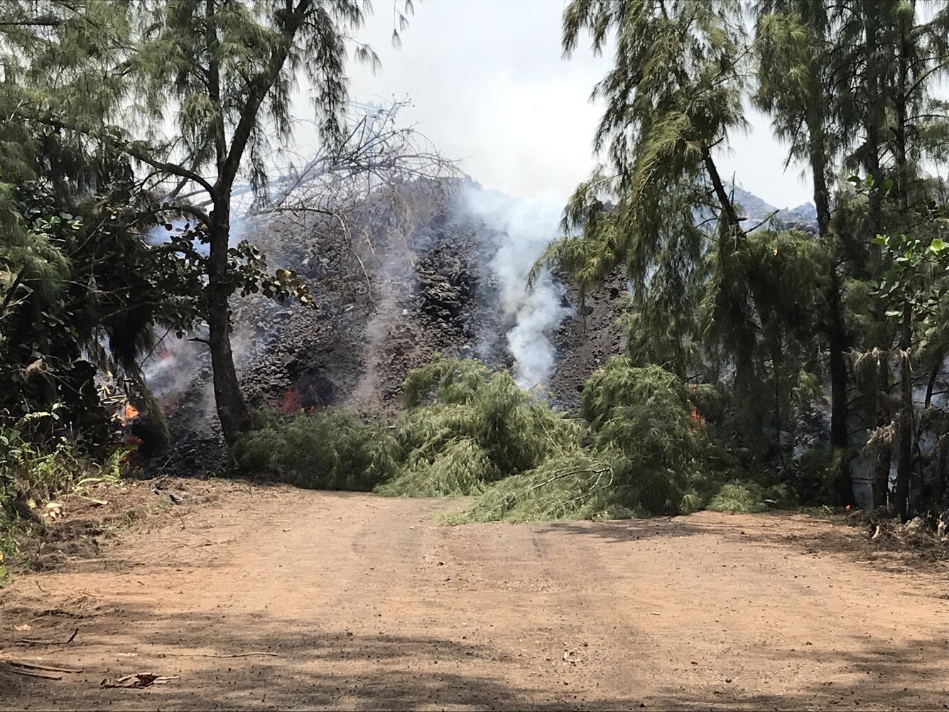
All other fissures are inactive, although observers on the late afternoon overflight noted abundant gas emission from Fissures 9 & 10 and incandescence without fountaining at fissures 16 & 18.
Pele's hair and other lightweight volcanic glass from high fountaining of Fissure 8 are falling downwind of the fissure and accumulating on the ground within Leilani Estates. Winds may waft lighter particles to greater distances. Residents are urged to minimize exposure to these volcanic particles, which can cause skin and eye irritation similar to volcanic ash.
The most recent map of lava flows can be found at https://volcanoes.usgs.gov/volcanoes/kilauea/multimedia_maps.html
HVO field crews are on site tracking the fountains, lava flows, and spattering from multiple fissures as conditions allow and are reporting information to Hawaii County Civil Defense.
Volcanic gas emissions remain very high from the fissure eruptions. Trade wind conditions are bringing vog to the south and west sides of the Island of Hawaii. Afternoon easterly winds may bring vog to communities in the Volcano area.
Magma continues to be supplied to the lower East Rift Zone. Earthquake locations have not moved farther downrift in the past few days and the number of located earthquakes remains low. Seismicity remains relatively low with numerous small magnitude earthquakes and low amplitude background tremor.
Additional ground cracking and outbreaks of lava in the area of the active fissures are possible. Residents downslope of the region of fissures should heed all Hawaii County Civil Defense messages and warnings.
Kīlauea Volcano Summit
Earthquake activity at the summit was high overnight and through the day. A moderate earthquake (5.5 preliminary) resulting from a volcanic explosion and continued collapse around Halemaumau occurred at 15:50 HST. National Weather Service radar observations confirmed an ash column was produced and reached 8,000 ft. asl.
Volcanic gas emissions at the summit remain high.

For forecasts of where ash would fall under forecast wind conditions, please consult the Ash3D model output here: https://volcanoes.usgs.gov/observatories/hvo/activity_2018.html
Information on volcanic ash hazards and how to prepare for ash fall maybe found at http://www.ivhhn.org/information#ash (health impacts) OR https://volcanoes.usgs.gov/volcanic_ash/ (other impacts).
For more information on how satellite imagery is being used to support the USGS eruption response, see the International Charter for Space and Major Disasters website.
UPDATE, 6/3/18, 10:40am HST
Kīlauea Volcano Lower East Rift Zone
Vigorous eruption of lava continues from the lower East Rift Zone (LERZ) fissure system in the area of Leilani Estates and Lanipuna Gardens.
Fissure 8 fountaining persisted throughout the night, and the channelized flow continued to deliver lava northeast along Highway 132 to the Kapoho area. Lava is advancing along a 0.5-mile-wide front towards the ocean at Kapoho Bay between Kapoho Beach Road and Kapoho Kai Drive. As of 7:30 AM HST, the lava flow was about 430 yards from the ocean. Other branches of the Fissure 8 lava flow were inactive.
All other fissures are inactive, although Fissure 9 is steaming heavily.

Pele's hair and other lightweight volcanic glass from high fountaining of Fissure 8 are falling downwind of the fissure and accumulating on the ground within Leilani Estates. Winds may waft lighter particles to greater distances. Residents are urged to minimize exposure to these volcanic particles, which can cause skin and eye irritation similar to volcanic ash.
The most recent map of lava flows can be found at https://volcanoes.usgs.gov/volcanoes/kilauea/multimedia_maps.html
HVO field crews are on site tracking the fountains, lava flows, and spattering from multiple fissures as conditions allow and are reporting information to Hawaii County Civil Defense.
Volcanic gas emissions remain very high from the fissure eruptions. Trade wind conditions are bringing vog to the south and west sides of the Island of Hawaii. Afternoon easterly winds may bring vog to communities in the Volcano area.
Magma continues to be supplied to the lower East Rift Zone. Earthquake locations have not moved farther downrift in the past few days and the number of located earthquakes remains low. Seismicity remains relatively low with numerous small magnitude earthquakes and low amplitude background tremor.
Additional ground cracking and outbreaks of lava in the area of the active fissures are possible. Residents downslope of the region of fissures should heed all Hawaii County Civil Defense messages and warnings.
Kīlauea Volcano Summit
Earthquake activity at the summit was high overnight, and it is possible that a small explosion, much like those that have occurred during the past two weeks, will take place in the next day. Ash emissions are low as revealed by webcam views this morning. Volcanic gas emissions at the summit remain high.

For forecasts of where ash would fall under forecast wind conditions, please consult the Ash3D model output here: https://volcanoes.usgs.gov/observatories/hvo/activity_2018.html
Information on volcanic ash hazards and how to prepare for ash fall maybe found at http://www.ivhhn.org/information#ash (health impacts) OR https://volcanoes.usgs.gov/volcanic_ash/ (other impacts).
For more information on how satellite imagery is being used to support the USGS eruption response, see the International Charter for Space and Major Disasters website.
UPDATE, 6/2/18, 7:39pm HST
Kīlauea Volcano Lower East Rift Zone
Vigorous eruption of lava continues from the lower East Rift Zone (LERZ) fissure system in the area of Leilani Estates and Lanipuna Gardens.
Fountaining at Fissure 8 continued unabated during the day, feeding a channelized lava flow to the northeast along Highway 132 that has crossed Highway 137 at the intersection of the two highways at 9:30 AM this morning. The flow continued advancing into Kapoho Crater and Kapoho Beach Lots. At 10 AM, lava entered Green Lake within Kapoho Crater producing a large steam plume. By 1:30 PM the steam plume had ceased and by 3 pm, a Hawaii County Fire Department overflight reported that lava had filled the lake and apparently evaporated all the water. Other branches of the Fissure 8 lava flow were inactive.

The only other lava flow noted by the morning overflight was at Fissure 16, which was weakly active.
Pele's hair and other lightweight volcanic glass from high fountaining of Fissure 8 are falling downwind of the fissure and accumulating on the ground within Leilani Estates. Winds may waft lighter particles to greater distances. Residents are urged to minimize exposure to these volcanic particles, which can cause skin and eye irritation similar to volcanic ash.
The most recent map of lava flows can be found at https://volcanoes.usgs.gov/volcanoes/kilauea/multimedia_maps.html.
HVO field crews are on site tracking the fountains, lava flows, and spattering from multiple fissures as conditions allow and are reporting information to Hawaii County Civil Defense.
Volcanic gas emissions remain very high from the fissure eruptions. Trade wind conditions are bringing vog to the south and west sides of the Island of Hawaii.
Magma continues to be supplied to the lower East Rift Zone. Earthquake locations have not moved farther downrift in the past few days and the number of located earthquakes remains low. Seismicity remains relatively low with numerous small magnitude earthquakes and low amplitude background tremor.
Additional ground cracking and outbreaks of lava in the area of the active fissures are possible. Residents downslope of the region of fissures should heed all Hawaii County Civil Defense messages and warnings.

Kīlauea Volcano Summit
Earthquake activity at the summit overnight was low. Ash emissions are low as revealed by webcam views this morning. Small explosive events could produce minor amounts of ash fall downwind at any time. Volcanic gas emissions at the summit remain high.
For forecasts of where ash would fall under forecast wind conditions, please consult the Ash3D model output here: https://volcanoes.usgs.gov/observatories/hvo/activity_2018.html
Information on volcanic ash hazards and how to prepare for ash fall maybe found at http://www.ivhhn.org/information#ash (health impacts) OR https://volcanoes.usgs.gov/volcanic_ash/ (other impacts).
For more information on how satellite imagery is being used to support the USGS eruption response, see the International Charter for Space and Major Disasters website.
UPDATE, 6/2/18, 9:20am HST
Kīlauea Volcano Lower East Rift Zone
Vigorous eruption of lava continues from the lower East Rift Zone (LERZ) fissure system in the area of Leilani Estates and Lanipuna Gardens.
Fountaining at Fissure 8 continued unabated overnight, feeding a channelized lava flow to the northeast along Highway 132 and down into the Four Corners region (at the intersection of Highways 132 and 137). As of 6:40 AM HST, the flow front was approximately 100 yards west of the intersection and advancing along a broad front over 300 yards in width extending both north and south of Highway 132. Small overflows from the Fissure 8 channel are common, some of which are occurring near the intersection of Highway 132 and Pohoiki road. Other branches of the Fissure 8 lava flow were inactive.
The only other lava flow noted by the morning overflight was at Fissure 16, which was weakly active.
Pele's hair and other lightweight volcanic glass from high fountaining of Fissure 8 are falling downwind of the fissure and accumulating on the ground within Leilani Estates. Winds may waft lighter particles to greater distances. Residents are urged to minimize exposure to these volcanic particles, which can cause skin and eye irritation similar to volcanic ash.
The most recent map of lava flows can be found at https://volcanoes.usgs.gov/volcanoes/kilauea/multimedia_maps.html.
HVO field crews are on site tracking the fountains, lava flows, and spattering from multiple fissures as conditions allow and are reporting information to Hawaii County Civil Defense.
Volcanic gas emissions remain very high from the fissure eruptions. Trade wind conditions are bringing vog to the south and west sides of the Island of Hawaii.
Magma continues to be supplied to the lower East Rift Zone. Earthquake locations have not moved farther downrift in the past few days and the number of located earthquakes remains low. Seismicity remains relatively low with numerous small magnitude earthquakes and low amplitude background tremor.
Additional ground cracking and outbreaks of lava in the area of the active fissures are possible. Residents downslope of the region of fissures should heed all Hawaii County Civil Defense messages and warnings.

Kīlauea Volcano Summit
Earthquake activity at the summit overnight was calm. Ash emissions are low as revealed by webcam views this morning. Small explosive events, like that of Friday afternoon, could produce minor amounts of ash fall downwind at any time. Volcanic gas emissions at the summit remain high.
For forecasts of where ash would fall under forecast wind conditions, please consult the Ash3D model output here: https://volcanoes.usgs.gov/observatories/hvo/activity_2018.html
Information on volcanic ash hazards and how to prepare for ash fall maybe found at http://www.ivhhn.org/information#ash (health impacts) OR https://volcanoes.usgs.gov/volcanic_ash/ (other impacts).
For more information on how satellite imagery is being used to support the USGS eruption response, see the International Charter for Space and Major Disasters website.
UPDATE, 6/1/18, 10:29pm HST
Kīlauea Volcano Lower East Rift Zone
Vigorous eruption of lava continues from the lower East Rift Zone (LERZ) fissure system in the area of Leilani Estates and Lanipuna Gardens.
Fountaining at Fissure 8 is reaching 180 - 220 feet in height and continues to feed a channelized lava flow to the northeast along Highway 132 and down into the Four Corners region (at the intersection of Highways 132 and 137). Small overflows from the channel are occurring along its length, including in a few places near the intersection of Highway 132 and Pohoiki road. As of 9:50 PM HST the flow front was approximately 0.28 miles from the intersection. The more western branches of the Fissure 8 flow either stalled or advanced only short distances.

Fissure 18 appears to be crusted over or inactive. The flows that had been moving toward Highway 137 are either inactive or moving very slowly. Fissure 22 appears to be inactive.
Pele's hair and other lightweight volcanic glass from high fountaining of Fissure 8 are falling downwind of the fissure and accumulating on the ground within Leilani Estates. Winds may waft lighter particles to greater distances. Residents are urged to minimize exposure to these volcanic particles, which can cause skin and eye irritation similar to volcanic ash.
The most recent map of lava flows can be found at https://volcanoes.usgs.gov/volcanoes/kilauea/multimedia_maps.html.
HVO field crews are on site tracking the fountains, lava flows, and spattering from multiple fissures as conditions allow and are reporting information to Hawaii County Civil Defense.
Volcanic gas emissions remain very high from the fissure eruptions. Trade wind conditions are bringing vog to the south and west sides of the Island of Hawaii.
Magma continues to be supplied to the lower East Rift Zone. Earthquake locations have not moved farther downrift in the past few days and the number of located earthquakes remains low. Seismicity remains relatively low with numerous small magnitude earthquakes and low amplitude background tremor.
Additional ground cracking and outbreaks of lava in the area of the active fissures are possible. Residents downslope of the region of fissures should heed all Hawaii County Civil Defense messages and warnings.
Kīlauea Volcano Summit
A small explosion occurred form the summit at 1:39 PM HST. Ash emissions are overall decreased, however, possibly reflecting the accumulation of rubble at the base of the growing summit crater. Earthquake activity remains high due to ongoing summit deflation. Additional explosive events that could produce minor amounts of ash fall downwind are possible at any time. Volcanic gas emissions at the summit remain high.
For forecasts of where ash would fall under forecast wind conditions, please consult the Ash3D model output here: https://volcanoes.usgs.gov/observatories/hvo/activity_2018.html
Information on volcanic ash hazards and how to prepare for ash fall maybe found at http://www.ivhhn.org/information#ash (health impacts) OR https://volcanoes.usgs.gov/volcanic_ash/ (other impacts).
For more information on how satellite imagery is being used to support the USGS eruption response, see the International Charter for Space and Major Disasters website.
UPDATE, 6/1/18, 9:21am HST
Kīlauea Volcano Lower East Rift Zone
Vigorous eruption of lava continues from the lower East Rift Zone (LERZ) fissure system in the area of Leilani Estates and Lanipuna Gardens.
Overnight, fountaining at Fissure 8 continued to feed a channelized lava flow to the northeast along Highway 132. Small overflows from the channel are occurring along its length, including in a few places near the intersection of Highway 132 and Pohoiki road. The advance rates of the distal part of the flow overnight were low as lava ponded in a flat area. In the last few hours, advance rates have picked up to about 100 yards/hour. As of 6:30 AM HST, the lava flow front was 0.84 miles above Four Corners (the intersection of Highway 132 and 137). Minor advancement occurred on other branches of the Fissure 8 lava flow.
Fissure 18 and its associated flow are weakly active with widely scattered lava breakouts. Fissure 22 is inactive.
Pele's hair and other lightweight volcanic glass from high fountaining of Fissure 8 are falling downwind of the fissure and accumulating on the ground within Leilani Estates. Winds may waft lighter particles to greater distances. Residents are urged to minimize exposure to these volcanic particles, which can cause skin and eye irritation similar to volcanic ash.
The most recent map of lava flows can be found here: https://volcanoes.usgs.gov/volcanoes/kilauea/multimedia_maps.html
HVO field crews are on site tracking the fountains, lava flows, and spattering from multiple fissures as conditions allow and reporting information to Hawaii County Civil Defense.
Volcanic gas emissions remain very high from the fissure eruptions. Trade wind conditions are bringing vog to the south and west sides of the Island of Hawaii.
Magma continues to be supplied to the lower East Rift Zone. Earthquake locations have not moved farther downrift in the past few days and the number of located earthquakes remains low. Seismicity at the summit remain low with numerous small magnitude earthquakes and low amplitude background tremor.
Additional ground cracking and outbreaks of lava in the area of the active fissures are possible. Residents downslope of the region of fissures should heed all Hawaii County Civil Defense messages and warnings.
Kīlauea Volcano Summit
Ash emissions are much diminished over the past day, possibly reflecting the accumulation of rubble at the base of the growing summit eruptive vent. This morning, the summit plume is whitish, reflecting mostly steam mixed with some ash. Earthquake activity remains high due to continued summit deflation. Additional explosive events that could produce minor amounts of ash fall downwind are possible at any time. Volcanic gas emissions at the summit remain high.
For forecasts of where ash would fall under forecast wind conditions, please consult the Ash3D model output here: https://volcanoes.usgs.gov/observatories/hvo/activity_2018.html
Information on volcanic ash hazards and how to prepare for ash fall maybe found at http://www.ivhhn.org/information#ash (health impacts) OR https://volcanoes.usgs.gov/volcanic_ash/ (other impacts).
For more information on how satellite imagery is being used to support the USGS eruption response, see the International Charter for Space and Major Disasters website.
UPDATE, 5/31/18, 10:43pm HST
Kīlauea Volcano Lower East Rift Zone
Vigorous eruption of lava continues from the lower East Rift Zone (LERZ) fissure system in the area of Leilani Estates and Lanipuna Gardens.
Fissure 8 is continuing to produce persistent fountains that are reaching heights of up to 260 feet. A small spatter cone is forming on the downwind side of the fountain and is approximately 100 feet high. The fountains are feeding a major flow field heading north through Leilani Estates and then to the northeast along the course of Highway 132. Minor overflows from the margins of the channel are occurring along its length. The front of the Fissure 8 flow is advancing through agricultural lands and had crossed Railroad Avenue by 7:30 PM HST. Ground and UAS crews are in the area closely monitoring the progress of the Fissure 8 flow front. At 21:53 PM HST, the flow front was approximately 1.1 miles from the Four Corners area (the intersection of Highways 132 and 137).
The Fissure 18 flow that advanced to within 0.5 mi of Highway 137 has stagnated. The new flow that branches from the same channel 1.5 miles upslope appears to have captured most of the lava output from Fissure 18. It is descending downslope just to the south of the previous flow.
Fissure 22 is weakly active, and lava is pooling around the vent.
Pele's hair and other lightweight volcanic glass from high fountaining of Fissure 8 are falling downwind of the fissure and accumulating on the ground within Leilani Estates. Winds may waft lighter particles to greater distances. Residents are urged to minimize exposure to these volcanic particles, which can cause skin and eye irritation similar to volcanic ash.
The most recent map of lava flows can be found here: https://volcanoes.usgs.gov/volcanoes/kilauea/multimedia_maps.html
HVO field crews are on site tracking the fountains, lava flows, and spattering from multiple fissures as conditions allow and reporting information to Hawaii County Civil Defense.
Volcanic gas emissions remain very high from the fissure eruptions. Trade wind conditions are bringing vog to the south and west sides of the Island of Hawaii.
Magma continues to be supplied to the lower East Rift Zone. Earthquake locations have not moved farther downrift in the past few days and the number of located earthquakes remains low. Seismicity at the summit remain low with numerous small magnitude earthquakes and low amplitude background tremor.
Additional ground cracking and outbreaks of lava in the area of the active fissures are possible. Residents downslope of the region of fissures should heed all Hawaii County Civil Defense messages and warnings.
Kīlauea Volcano Summit
Ash continued to erupt intermittently from the vent within Halemaʻumaʻu crater at Kīlauea's summit. Additional explosive events that could produce minor amounts of ash fall downwind are possible at any time. Earthquake activity is elevated at the summit, with many small events. Volcanic gas emissions at the summit remain high.
For forecasts of where ash would fall under forecast wind conditions, please consult the Ash3D model output here: https://volcanoes.usgs.gov/observatories/hvo/activity_2018.html
Information on volcanic ash hazards and how to prepare for ash fall maybe found at http://www.ivhhn.org/information#ash (health impacts) OR https://volcanoes.usgs.gov/volcanic_ash/ (other impacts).
For more information on how satellite imagery is being used to support the USGS eruption response, see the International Charter for Space and Major Disasters website.
UPDATE, 5/31/18, 6:41pm HST
Kīlauea Volcano Lower East Rift Zone
Vigorous eruption of lava continues from the lower East Rift Zone (LERZ) fissure system in the area of Leilani Estates and Lanipuna Gardens.
Fissure 8 continued to produce persistent fountains that reached heights up to 260 feet. A small spatter cone is forming on the downwind side of the fountain and is approximately 100 feet high. The fountains are feeding flow activity to the northeast, and minor overflows from the Fissure 8 channel are occurring along its length. One overflow covered the remaining northern part of Makamae Street in Leilani Estates. This overflow crossed Kahukai street, filling in a low area between Makamae and Luana streets. The front of the Fissure 8 flow near Noni Farms road advanced at rates up to 100 yards/hour. At 12:30 PM HST, the flow front was 1.9 miles from the Four Corners area.
High eruption rates from Fissure 8 have led to the formation of a leveed channel along the western edge of the lava flow. Failure of flow levees could result in rapid advance of flows. Flow margins are extremely hazardous and should not be approached.
Fissure 18 feeds the upper part of a lava flow that extends to 1.5 mi from Highway 137; the lower portion of the fissure 18 lava flow stalled about 0.5 mi from the highway. Fissure 2 is weakly active and is pooling lava around the vent.
Pele's hair and other lightweight volcanic glass from high fountaining of Fissure 8 are falling downwind of the fissure and accumulating on the ground within Leilani Estates. Winds may waft lighter particles to greater distances. Residents are urged to minimize exposure to these volcanic particles, which can cause skin and eye irritation similar to volcanic ash.
The most recent map of lava flows can be found here: https://volcanoes.usgs.gov/volcanoes/kilauea/multimedia_maps.html
HVO field crews are on site tracking the fountains, lava flows, and spattering from multiple fissures as conditions allow and reporting information to Hawaii County Civil Defense. Crews are also checking on the status of ground cracks on Highway 130.
Volcanic gas emissions remain very high from the fissure eruptions. Trade wind conditions are bringing vog to the south and west sides of the Island of Hawaii.
Magma continues to be supplied to the lower East Rift Zone. Earthquake locations have not moved farther downrift in the past few days and the number of located earthquakes remains low.
Additional ground cracking and outbreaks of lava in the area of the active fissures are possible. Residents downslope of the region of fissures should heed all Hawaii County Civil Defense messages and warnings.
Kīlauea Volcano Summit
Ash continued to erupt intermittently from the vent within Halemaʻumaʻu crater at Kīlauea's summit. Additional explosive events that could produce minor amounts of ash fall downwind are possible at any time. Earthquake activity is elevated at the summit, with many small events occurring overnight. Volcanic gas emissions at the summit remain high.
For forecasts of where ash would fall under forecast wind conditions, please consult the Ash3D model output here: https://volcanoes.usgs.gov/observatories/hvo/activity_2018.html
Information on volcanic ash hazards and how to prepare for ash fall maybe found at http://www.ivhhn.org/information#ash (health impacts) OR https://volcanoes.usgs.gov/volcanic_ash/ (other impacts).
For more information on how satellite imagery is being used to support the USGS eruption response, see the International Charter for Space and Major Disasters website.
UPDATE, 5/31/18, 11:27am HST
Kīlauea Volcano Lower East Rift Zone
Vigorous eruption of lava continues from the lower East Rift Zone (LERZ) fissure system in the area of Leilani Estates and Lanipuna Gardens.
Overnight, Fissure 8 continued to produce persistent fountains that reached heights of 200-250 feet. A small spatter cone is forming on the downwind side of the fountain and is approximately 100 feet high. The fountains are feeding flow activity to the northeast, and minor overflows from the Fissure 8 channel are occurring along its length. One overflow covered the remaining northern part of Makamae Street in Leilani Estates. This overflow crossed Kahukai street, filling in a low area between Makamae and Luana streets. The front of the Fissure 8 flow near Noni Farms road advanced at rates of about 80 yards/hour. At 6:15 AM HST, the flow front was 2.2 miles above the Four Corners area.
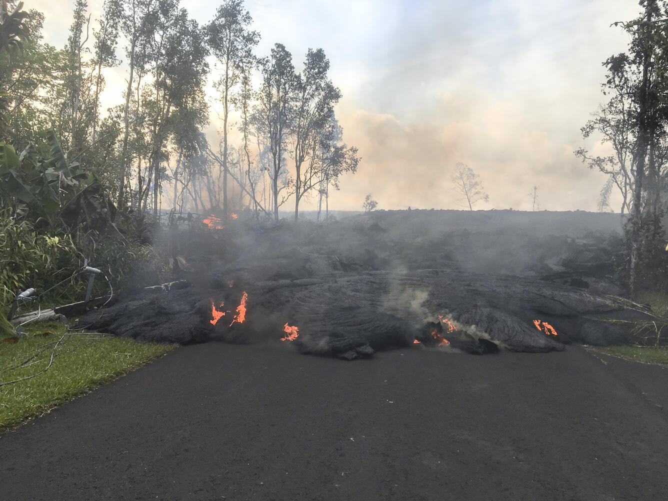
High eruption rates from Fissure 8 have led to the formation of a leveed channel along the western edge of the lava flow. Failure of flow levees could result in rapid advance of flows. Flow margins are extremely hazardous and should not be approached.
Additional eruptive activity overnight occurred from Fissure 7/21. Fissure 18 is also active, but the lava flow, which was moving toward Highway 137 last night, has stalled.
Pele's hair and other lightweight volcanic glass from high fountaining of Fissure 8 are falling downwind of the fissure and accumulating on the ground within Leilani Estates. Winds may waft lighter particles to greater distances. Residents are urged to minimize exposure to these volcanic particles, which can cause skin and eye irritation similar to volcanic ash.
The most recent map of lava flows can be found here: https://volcanoes.usgs.gov/volcanoes/kilauea/multimedia_maps.html
HVO field crews are on site tracking the fountains, lava flows, and spattering from multiple fissures as conditions allow and reporting information to Hawaii County Civil Defense. Crews are also checking on the status of ground cracks on Highway 130.
Volcanic gas emissions remain very high from the fissure eruptions. Trade wind conditions are bringing vog to the south and west sides of the Island of Hawaii.
Magma continues to be supplied to the lower East Rift Zone. Earthquake locations have not moved farther downrift in the past few days and the number of located earthquakes remains low.
Additional ground cracking and outbreaks of lava in the area of the active fissures are possible. Residents downslope of the region of fissures should heed all Hawaii County Civil Defense messages and warnings.
Kīlauea Volcano Summit
Ash continued to erupt intermittently from the vent within Halemaʻumaʻu crater at Kīlauea's summit. Additional explosive events that could produce minor amounts of ash fall downwind are possible at any time. Earthquake activity is elevated at the summit, with many small events occurring overnight. Volcanic gas emissions at the summit remain high.
For forecasts of where ash would fall under forecast wind conditions, please consult the Ash3D model output here: https://volcanoes.usgs.gov/observatories/hvo/activity_2018.html
Information on volcanic ash hazards and how to prepare for ash fall maybe found at http://www.ivhhn.org/information#ash (health impacts) OR https://volcanoes.usgs.gov/volcanic_ash/ (other impacts).
For more information on how satellite imagery is being used to support the USGS eruption response, see the International Charter for Space and Major Disasters website.
UPDATE, 5/30/18, 10:11pm HST
Kīlauea Volcano Lower East Rift Zone
Vigorous eruption of lava continues from the lower East Rift Zone (LERZ) fissure system in the area of Leilani Estates and Lanipuna Gardens.
Fissure 8 continues to maintain eruptive fountains reaching 200-250 feet. Subsidiary fountains in the vicinity of Fissure 8 are also active although with much less vigor, seldom exceeding 60 feet in height. This fountaining continues to feed a lava flow that is moving north out of Leilani Estates and then northeast along Highway 132 into the area of Noni Farms road. Flow front advance has slowed to less than 50 yards per hour.
By late afternoon, the front of the Fissure 18 flow was about 0.5 miles from Highway 137 and was spreading and slowing. In the late afternoon, a new flow lobe began branching from the south side of the fissure 18 flow approximately 1.5 miles upslope from the flow front. During the day, sporadic bursts of activity were also observed from Fissures 22, 6, and 13. Low level spattering and intermittent fountaining from Fissure 21 were also observed in the late afternoon and early evening.
Pele's hair and and other lightweight volcanic glass from high fountaining of Fissure 8 are falling to the west of the fissure and accumulating on the ground within Leilani Estates. Winds may waft lighter particles to greater distances. Residents are urged to minimize exposure to these volcanic particles, which can cause skin and eye irritation similar to volcanic ash.
The most recent map of lava flows can be found here: https://volcanoes.usgs.gov/volcanoes/kilauea/multimedia_maps.html
HVO field crews are on site tracking the fountains, lava flows, and spattering from multiple fissures as conditions allow and reporting information to Hawaii County Civil Defense. Crews are also checking on the status of ground cracks on Highway 130.

Volcanic gas emissions remain very high from the fissure eruptions. Trade wind conditions are bringing vog to the south and west sides of the Island of Hawaii.
Magma continues to be supplied to the lower East Rift Zone. Earthquake locations have not moved farther downrift in the past few days and the number of located earthquakes remains low.
Additional ground cracking and outbreaks of lava in the area of the active fissures are possible. Residents downslope of the region of fissures should heed all Hawaii County Civil Defense messages and warnings.
Kīlauea Volcano Summit
Ash continued to erupt intermittently from the vent within Halemaʻumaʻu crater at Kīlauea's summit. Additional explosive events that could produce minor amounts of ash fall downwind are possible at any time. Earthquake activity is elevated at the summit, with a few felt events reported throughout the day. Volcanic gas emissions at the summit remain high.

For forecasts of where ash would fall under forecast wind conditions, please consult the Ash3D model output here: https://volcanoes.usgs.gov/observatories/hvo/activity_2018.html
Information on volcanic ash hazards and how to prepare for ash fall maybe found at http://www.ivhhn.org/information#ash (health impacts) OR https://volcanoes.usgs.gov/volcanic_ash/ (other impacts).
For more information on how satellite imagery is being used to support the USGS eruption response, see the International Charter for Space and Major Disasters website.
UPDATE, 5/30/18, 7:24pm HST
Kīlauea Volcano Lower East Rift Zone
Vigorous eruption of lava continues from the lower East Rift Zone (LERZ) fissure system in the area of Leilani Estates and Lanipuna Gardens.
Fissure 8 maintained high fountains through Wednesday with sustained heights exceeding 200 feet and the presence of multiple secondary fountains that reached to 60 feet. This fountaining continued to feed a lava flow that moved downslope along Highway 132. Advance rates were less than 100 yards/hour for the three lobes of the flow. The flow moved north of Highway 132 in the vicinity of Noni Farms and Halekamahina roads, from which the two easternmost lobes advanced in a more east northeasterly direction while the westernmost lobe advanced in a northeasterly direction.
The Fissure 18 flow also remained active, moving downslope toward Highway 137 at rates of much less than 100 yards per hour. During the day, sporadic bursts of activity were also observed from Fissures 22, 6, and 13.
Pele's hair and and other lightweight volcanic glass from high fountaining of Fissure 8 are falling to the west of the fissure and accumulating on the ground within Leilani Estates. Winds my waft lighter particles to greater distances. Residents are urged to minimize exposure to these volcanic particles, which can cause skin and eye irritation similar to volcanic ash.
The most recent map of lava flows can be found here: https://volcanoes.usgs.gov/volcanoes/kilauea/multimedia_maps.html
HVO field crews are on site tracking the fountains, lava flows, and spattering from multiple fissures as conditions allow and reporting information to Hawaii County Civil Defense. Crews are also checking on the status of ground cracks on Highway 130.
Volcanic gas emissions remain very high from the fissure eruptions. Wind conditions for Wednesday, May 30, are forecast to result in widespread vog over the Island of Hawaii.
Magma continues to be supplied to the lower East Rift Zone. Earthquake locations have not moved farther downrift in the past few days and the number of located earthquakes remains low.
Additional ground cracking and outbreaks of lava in the area of the active fissures are possible. Residents downslope of the region of fissures should heed all Hawaii County Civil Defense messages and warnings.
Kīlauea Volcano Summit
Ash continued to erupt intermittently from the vent within Halemaʻumaʻu crater, at Kīlauea's summit. The National Weather Service observed an ash column rising to 12,000 ft at around 11 am this morning but visibility was very poor on the ground and ground observers could confirm the event. Additional explosive events that could produce minor amounts of ash fall downwind are possible at any time. Earthquake activity is elevated at the summit, with a few felt events reported overnight. Volcanic gas emissions at the summit remain high and will combine with wind conditions to produce widespread vog across the Island of Hawaii on Wednesday.
For forecasts of where ash would fall under forecast wind conditions, please consult the Ash3D model output here: https://volcanoes.usgs.gov/observatories/hvo/activity_2018.html
Information on volcanic ash hazards and how to prepare for ash fall maybe found at http://www.ivhhn.org/information#ash (health impacts) OR https://volcanoes.usgs.gov/volcanic_ash/ (other impacts).
For more information on how satellite imagery is being used to support the USGS eruption response, see the International Charter for Space and Major Disasters website
UPDATE, 5/30/18, 6:43am HST
Kīlauea Volcano Lower East Rift Zone
Vigorous eruption of lava continues from the lower East Rift Zone (LERZ) fissure system in the area of Leilani Estates and Lanipuna Gardens.
Fissure 8 maintained high fountains throughout Tuesday night and into Wednesday morning, with sustained heights exceeding 200 feet and the presence of multiple secondary fountains that reached to 60 feet. This fountaining continued to feed a lava flow that moved downslope along Highway 132. Advance rates accelerated late Tuesday and early Wednesday, reaching approximately 600 yards/hour. The flow moved north of Highway 132 in the vicinity of Noni Farms and Halekamahina roads, advancing along a steepest descent path that could take the flow to the Four Corners area.
The Fissure 18 flow also remained active, moving downslope toward Highway 137 at rates of less than 100 yards per hour. Overnight, sporadic bursts of activity were also observed from Fissures 7 and 15.
Pele's hair and and other lightweight volcanic glass from high fountaining of Fissure 8 are falling to the west of the fissure and accumulating on the ground within Leilani Estates. Winds my waft lighter particles to greater distances. Residents are urged to minimize exposure to these volcanic particles, which can cause skin and eye irritation similar to volcanic ash.
The most recent map of lava flows can be found here: https://volcanoes.usgs.gov/volcanoes/kilauea/multimedia_maps.html
HVO field crews are on site tracking the fountains, lava flows, and spattering from multiple fissures as conditions allow and reporting information to Hawaii County Civil Defense. Crews are also checking on the status of ground cracks on Highway 130.
Volcanic gas emissions remain very high from the fissure eruptions. Wind conditions for Wednesday, May 30, are forecast to result in widespread vog over the Island of Hawaii.
Magma continues to be supplied to the lower East Rift Zone. Earthquake locations have not moved farther downrift in the past few days and the number of located earthquakes remains low.
Additional ground cracking and outbreaks of lava in the area of the active fissures are possible. Residents downslope of the region of fissures should heed all Hawaii County Civil Defense messages and warnings.
Kīlauea Volcano Summit
Ash continued to erupt intermittently from the vent within Halemaʻumaʻu crater, at Kīlauea's summit, but no small explosive events have been recorded since Tuesday morning. Additional explosive events that could produce minor amounts of ash fall downwind are possible at any time. Earthquake activity is elevated at the summit, with a few events reported felt overnight. Volcanic gas emissions at the summit remain high and will combine with wind conditions to produce widespread vog across the Island of Hawaii on Wednesday.
For forecasts of where ash would fall under forecast wind conditions, please consult the Ash3D model output here: https://volcanoes.usgs.gov/observatories/hvo/activity_2018.html
Information on volcanic ash hazards and how to prepare for ash fall maybe found at http://www.ivhhn.org/information#ash (health impacts) OR https://volcanoes.usgs.gov/volcanic_ash/ (other impacts).
For more information on how satellite imagery is being used to support the USGS eruption response, see the International Charter for Space and Major Disasters website
UPDATE, 5/29/18, 10:28pm HST
Kīlauea Volcano Lower East Rift Zone
Vigorous eruption of lava continues from the lower East Rift Zone (LERZ) fissure system in the area of Leilani Estates and Lanipuna Gardens.
Fissure 8 remained very active Tuesday afternoon and evening, fountaining to heights of 200 feet at times and feeding a lava flow that advanced atop an existing flow (which was emplaced on Sunday night/Monday morning). After a finger of lava crossed Highway 132 earlier this afternoon near the PGV access road, the bulk of the lava remained on the south side of the highway, roughly paralleling the highway as it moved downslope.
Visual observations early Tuesday afternoon also confirmed continued weak activity at Fissures 18 and 16. Fissure 18 is producing channelized flows which had advanced to within 0.9 miles of the coast as of 7:10 PM HST. On Tuesday evening, Hawaii County Civil Defense began providing preliminary warnings to residents in the area to be prepared to evacuate if the flow continues to advance and threatens to cut Highway 137.
Pele's hair and and other lightweight volcanic glass from high fountaining of Fissure 8 are being transported downwind and falling to the west of the fissure. On Monday night, there were reports of Pele's hair falling in Pāhoa. Residents are urged to minimize exposure to these volcanic particles, which can cause skin and eye irritation similar to volcanic ash.
The most recent map of lava flows can be found here: https://volcanoes.usgs.gov/volcanoes/kilauea/multimedia_maps.html
HVO field crews are on site tracking the fountains, lava flows, and spattering from multiple fissures as conditions allow and reporting information to Hawaii County Civil Defense. Crews are also checking on the status of ground cracks on Highway 130.
Volcanic gas emissions remain very high from the fissure eruptions. Trade winds are forecast to return in the coming days, meaning that vog may impact the southern and western sides of the island.
Magma continues to be supplied to the lower East Rift Zone. Earthquake locations have not moved farther downrift in the past few days and the number of located earthquakes remains low.
Additional ground cracking and outbreaks of lava in the area of the active fissures are possible. Residents downslope of the region of fissures should heed all Hawaii County Civil Defense messages and warnings.
Kīlauea Volcano Summit
Ash continued to erupt intermittently from the vent within Halemaʻumaʻu crater, at Kīlauea's summit. Additional explosive events that could produce minor amounts of ash fall downwind are possible at any time. Volcanic gas emissions at the summit remain high.
For forecasts of where ash would fall under forecast wind conditions, please consult the Ash3D model output here: https://volcanoes.usgs.gov/observatories/hvo/activity_2018.html
Information on ash hazards and how to prepare for ashfall maybe found here: http://www.ivhhn.org/information#ash

For more information on how satellite imagery is being used to support the USGS eruption response, see the International Charter for Space and Major Disasters website
MORE INFORMATION
Activity Summary also available by phone: (808) 967-8862
Subscribe to these messages: https://volcanoes.usgs.gov/vns2/
Webcam images: https://volcanoes.usgs.gov/volcanoes/kilauea/multimedia_webcams.html
Photos/Video: https://volcanoes.usgs.gov/volcanoes/kilauea/multimedia_chronology.html
Lava Flow Maps: https://volcanoes.usgs.gov/volcanoes/kilauea/multimedia_maps.html
Definitions of terms used in update: https://volcanoes.usgs.gov/volcanoes/kilauea/extra/definitions.pdf
Overview of Kīlauea summit (Halemaʻumaʻu) and East Rift Zone (Puʻu ʻŌʻō ) eruptions:
https://volcanoes.usgs.gov/volcanoes/kilauea/extra/background.pdf
Summary of volcanic hazards from Kīlauea eruptions:
https://volcanoes.usgs.gov/volcanoes/kilauea/extra/hazards.pdf
Recent Earthquakes in Hawai'i (map and list):
https://volcanoes.usgs.gov/hvo/earthquakes/
Explanation of Volcano Alert Levels and Aviation Color Codes:
https://volcanoes.usgs.gov/activity/alertsystem/index.php
https://pubs.usgs.gov/fs/2006/3139/
CONTACT INFORMATION:
askHVO@usgs.gov
The Hawaiian Volcano Observatory is one of five volcano observatories within the U.S. Geological Survey and is responsible for monitoring volcanoes and earthquakes in Hawai`i.
UPDATE, 5/29/18, 4:51pm HST
Kīlauea Volcano Lower East Rift Zone
Vigorous eruption of lava continues from the lower East Rift Zone (LERZ) fissure system in the area of Leilani Estates and Lanipuna Gardens.
Fissure 8 remained very active today fountaining to heights of 200 feet at times and feeding a lava flow that advanced atop the Fissure 8 ʻaʻā flow that was active Sunday night/Monday morning. The first lobe of this flow crossed highway 132 just before 2 pm HST Tuesday. Lava continues to advance toward the northeast.

Visual observations early Tuesday afternoon also confirmed continued weak activity at Fissures 18 and 19. Fissure 18 has produced channelized flows which have advanced 1.6 mi toward the coast.
Pele's hair and and other lightweight volcanic glass from high fountaining of Fissure 8 are being transported downwind and falling to the west of the fissure. On Monday night, there were reports of Pele's hair falling in Pāhoa. Residents are urged to minimize exposure to these volcanic particles, which can cause skin and eye irritation similar to volcanic ash.
The most recent map of lava flows can be found here: https://volcanoes.usgs.gov/volcanoes/kilauea/multimedia_maps.html
HVO field crews are on site tracking the fountains, lava flows, and spattering from multiple fissures as conditions allow and reporting information to Hawaii County Civil Defense. Crews are also checking on the status of ground cracks on Highway 130.
Volcanic gas emissions remain very high from the fissure eruptions. Trade winds are forecast to return in the coming days, meaning that vog may impact the southern and western sides of the island.
Magma continues to be supplied to the lower East Rift Zone. Earthquake locations have not moved farther downrift in the past few days and the number of located earthquakes remains low.
Additional ground cracking and outbreaks of lava in the area of the active fissures are possible. Residents downslope of the region of fissures should heed all Hawaii County Civil Defense messages and warnings.
Kīlauea Volcano Summit
Ash continued to erupt intermittently from the vent within Halemaʻumaʻu crater, at Kīlauea's summit. Additional explosive events that could produce minor amounts of ash fall downwind are possible at any time. Volcanic gas emissions at the summit remain high.
For forecasts of where ash would fall under forecast wind conditions, please consult the Ash3D model output here: https://volcanoes.usgs.gov/observatories/hvo/activity_2018.html
Information on ash hazards and how to prepare for ashfall maybe found here: http://www.ivhhn.org/information#ash
UPDATE, 5/29/18, 7:45am HST
Kīlauea Volcano Lower East Rift Zone
Vigorous eruption of lava continues from the lower East Rift Zone (LERZ) fissure system in the area of Leilani Estates and Lanipuna Gardens.
Fissure 8 reactivated yesterday afternoon and, overnight, was fountaining to heights of 200 feet at times and feeding a lava flow that was traveling to the northeast. That flow was moving atop the Fissure 8 flow that was active the previous night, passing on to open ground and crossing Pohoiki road at about 5am HST. As of 7am Tuesday morning, lava is advancing along the north margin of an earlier lava flow from Fissure 7 toward the PGV access road.
Visual observations early Tuesday morning also confirmed continued weak activity at Fissures 18, 19, and 20. Fissure 18 has produced channelized flows which have advanced about one-third of the way (1.2 mi) toward the coast.
Pele's hair and and other lightweight volcanic glass from high fountaining of Fissure 8 are being transported downwind and falling to the west of the fissure. On Monday night, there were reports of Pele's hair falling in Pāhoa. Residents are urged to minimize exposure to these volcanic particles, which can cause skin and eye irritation similar to volcanic ash.
The most recent map of lava flows can be found here: https://volcanoes.usgs.gov/volcanoes/kilauea/multimedia_maps.html
HVO field crews are on site tracking the fountains, lava flows, and spattering from multiple fissures as conditions allow and reporting information to Hawaii County Civil Defense. Crews are also checking on the status of ground cracks on Highway 130.
Volcanic gas emissions remain very high from the fissure eruptions. Trade winds are forecast to return in the coming days, meaning that vog may impact the southern and western sides of the island.
Magma continues to be supplied to the lower East Rift Zone. Earthquake locations have not moved farther downrift in the past few days and the number of located earthquakes remains low.
Additional ground cracking and outbreaks of lava in the area of the active fissures are possible. Residents downslope of the region of fissures should heed all Hawaii County Civil Defense messages and warnings.
Kīlauea Volcano Summit
Ash continued to erupt intermittently from the vent within Halemaʻumaʻu crater, at Kīlauea's summit. At 1:56am HST, there was a small explosion that sent ash to 15,000' above sea level. The ash cloud rose vertically above the summit and drifted only slightly to the northwest owing to calm winds. The explosion was reported felt by a number of residents in the Volcano area, and it resulted in the emplacement of some incandescent blocks on the east floor/wall of Halemaʻumaʻu crater.
Additional explosive events that could produce minor amounts of ash fall downwind are possible at any time. Volcanic gas emissions at the summit remain high.
For forecasts of where ash would fall under forecast wind conditions, please consult the Ash3D model output here: https://volcanoes.usgs.gov/observatories/hvo/activity_2018.html
Information on ash hazards and how to prepare for ashfall maybe found here: http://www.ivhhn.org/information#ash
UPDATE, 5/28/18, 10:59pm HST
Kīlauea Volcano Lower East Rift Zone
Vigorous eruption of lava continues from the lower East Rift Zone (LERZ) fissure system in the area of Leilani Estates and Lanipuna Gardens.
Late this afternoon, vigorous fountaining resumed at Fissure 8, spawning a fast moving flow that moved north along Luana Street. As of 10:00 PM HST the flow front had reached within 300 yards of Kahukai street. The flow is traveling an estimated 20 yards per hour to the northeast. An overflight early this evening showed that Fissures 16, 18, 22,13, and 20 were active, with a flow moving south from Fissures 16/18.
Pele's hair from vigorous fountaining of Fissure 8 is being transported downwind, and there are reports of some strands falling in Pahoa. Residents are urged to minimize exposure to Pele's hair (volcanic glass), which can cause skin and eye irritation similar to volcanic ash.
The most recent map of lava flows can be found here: https://volcanoes.usgs.gov/volcanoes/kilauea/multimedia_maps.html
HVO field crews are on site tracking the fountains, lava flows, and spattering from multiple fissures as conditions allow and reporting information to Hawaii County Civil Defense. Crews are also checking on the status of ground cracks on Highway 130.

Volcanic gas emissions remain very high from the fissure eruptions. Trade winds are forecast to return in the coming days, meaning vog will impact the southern and western sides of the island.
Magma continues to be supplied to the lower East Rift Zone. Earthquake locations have not moved farther downrift in the past few days and the number of located earthquakes remains low.
Additional ground cracking and outbreaks of lava in the area of the active fissures are possible. Residents downslope of the region of fissures should heed all Hawaii County Civil Defense messages and warnings.
Kīlauea Volcano Summit
Ash continued to erupt intermittently from the vent within Halemaʻumaʻu crater, at Kīlauea's summit. Winds have weakened and shifted in direction so that ash fall could occur in communities around the summit area.
A magnitude 4.1 earthquake occurred at 5:39 PM HST on the Koa'e fault zone south of the caldera. Earthquakes in the summit region continue as the summit area subsides and adjusts to the withdrawal of magma.
Additional explosive events that could produce minor amounts of ash fall downwind are possible at any time. Volcanic gas emissions at the summit remain high.
For forecasts of where ash would fall under forecast wind conditons, please consult the Ash3D model output here: https://volcanoes.usgs.gov/observatories/hvo/activity_2018.html
Information on ash hazards and how to prepare for ashfall maybe found here: http://www.ivhhn.org/information#ash
UPDATE, 5/28/18, 4:35pm HST
Kīlauea Volcano Lower East Rift Zone
Vigorous eruption of lava continues from the lower East Rift Zone (LERZ) fissure system in the area of Leilani Estates and Lanipuna Gardens.
The lava flow from Fissure 8 reached Pohoiki Rd. this morning and stalled as the Fissure's activity abruptly diminished. A few fissures reactivated briefly during the day. As of the 1 pm overflight, Fissure 8, 18, 20, 22, 6/13, and 7/21 reactivated with Fissure 7/21 having the highest fountains. The reactivated fissures have not yet erupted enough lava to reach the coast so the two ocean entry sites were relatively inactive. Only a minor ooze of residual lava was entering the ocean from the Eastern channel.
The most recent map of lava flows can be found here: https://volcanoes.usgs.gov/volcanoes/kilauea/multimedia_maps.html

HVO field crews are on site tracking the fountains, lava flows, and spattering from multiple fissures as conditions allow and reporting information to Hawaii County Civil Defense. Crews are also checking on the status of ground cracks on Highway 130.
Volcanic gas emissions remain very high from the fissure eruptions. If a forecast shift in wind direction occurs today, widespread vog could occur on the Island of Hawaii.
Magma continues to be supplied to the lower East Rift Zone. Earthquake locations have not moved farther downrift in the past few days and the number of located earthquakes remains low.
Additional ground cracking and outbreaks of lava in the area of the active fissures are possible. Residents downslope of the region of fissures should heed all Hawaii County Civil Defense messages and warnings.
Kīlauea Volcano Summit
Ash continued to erupt intermittently from the vent within Halemaʻumaʻu crater, at Kīlauea's summit. Winds have weakened and shifted in direction so that ash fall could occur in communities around the summit area.
Earthquakes in the summit region continue as the summit area subsides and adjusts to the withdrawal of magma.
Additional explosive events that could produce minor amounts of ash fall downwind are possible at any time. Volcanic gas emissions at the summit remain high.
For forecasts of where ash would fall under forecast wind conditons, please consult the Ash3D model output here: https://volcanoes.usgs.gov/observatories/hvo/activity_2018.html
Information on ash hazards and how to prepare for ashfall maybe found here: http://www.ivhhn.org/information#ash
UPDATE, 5/28/18, 10:32am HST
Kīlauea Volcano Lower East Rift Zone
Vigorous eruption of lava continues from the lower East Rift Zone (LERZ) fissure system in the area of Leilani Estates and Lanipuna Gardens.
Overnight, field crews confirmed that the fast-moving flow that broke out at about 7 PM HST Sunday night originated from Fissure 8. The fissure fed a channelized flow that moved north along the margin of the existing flow before turning east and crossing out of Leilani Estates near the intersection of Kahukai and Hookupu streets. As of 8 AM HST Monday morning it had started to cross Pohoiki Road, but the advance rate slowed from hundreds of meters (yards) per hour on Sunday night to a few meters (yards) per hour this morning.

Fissures 6/13 are inactive, and Fissure 9 is reactivated but erupting small amounts of lava that are pooling nearby. Fissure 7/21 are no longer active and lava flows from that fissure have largely stalled on PGV property.
The most recent map of lava flows can be found here: https://volcanoes.usgs.gov/volcanoes/kilauea/multimedia_maps.html
HVO field crews are on site tracking the fountains, lava flows, and spattering from multiple fissures as conditions allow and reporting information to Hawaii County Civil Defense. Crews are also checking on the status of ground cracks on Highway 130.
Volcanic gas emissions remain very high from the fissure eruptions. If a forecast shift in wind direction occurs today, widespread vog may be expected on the Island of Hawaii.
Magma continues to be supplied to the lower East Rift Zone. Earthquake locations have not moved farther downrift in the past few days and the number of located earthquakes remains low.
Additional ground cracking and outbreaks of lava in the area of the active fissures are possible. Residents downslope of the region of fissures should heed all Hawaii County Civil Defense messages and warnings.
Kīlauea Volcano Summit
Ash continued to erupt intermittently from the vent within Halemaʻumaʻu crater, at Kīlauea's summit. A brief emission event at about 4:35 AM HST this morning sent ash to about 10,000 feet above sea level but was not associated with a significant tilt offset. A similar event at about 6:30 AM sent ash to approximately 12,000 feet above sea level. Earthquakes are currently occurring at high rates in the summit area. Observations from the ground, by UAS, and by satellite during the past week have documented retreat of the summit vent walls due to collapse of the steep conduit and rim. Trade winds are causing ash fall to the southwest. If a forecast shift in wind direction occurs today, ash fall may occur in communities around the summit area.
Earthquakes in the summit region continue as the summit area subsides and adjusts to the withdrawal of magma.
Additional explosive events that could produce minor amounts of ash fall downwind are possible at any time. Volcanic gas emissions at the summit remain high.
For forecasts of where ash would fall under forecast wind conditons, please consult the Ash3D model output here: https://volcanoes.usgs.gov/observatories/hvo/activity_2018.html
Information on ash hazards and how to prepare for ashfall maybe found here: http://www.ivhhn.org/information#ash
MORE INFORMATION
Activity Summary also available by phone: (808) 967-8862
Subscribe to these messages: https://volcanoes.usgs.gov/vns2/
Webcam images: https://volcanoes.usgs.gov/volcanoes/kilauea/multimedia_webcams.html
Photos/Video: https://volcanoes.usgs.gov/volcanoes/kilauea/multimedia_chronology.html
Lava Flow Maps: https://volcanoes.usgs.gov/volcanoes/kilauea/multimedia_maps.html
Definitions of terms used in update: https://volcanoes.usgs.gov/volcanoes/kilauea/extra/definitions.pdf
Overview of Kīlauea summit (Halemaʻumaʻu) and East Rift Zone (Puʻu ʻŌʻō ) eruptions:
https://volcanoes.usgs.gov/volcanoes/kilauea/extra/background.pdf
Summary of volcanic hazards from Kīlauea eruptions:
https://volcanoes.usgs.gov/volcanoes/kilauea/extra/hazards.pdf
Recent Earthquakes in Hawai'i (map and list):
https://volcanoes.usgs.gov/hvo/earthquakes/
Explanation of Volcano Alert Levels and Aviation Color Codes:
https://volcanoes.usgs.gov/activity/alertsystem/index.php
https://pubs.usgs.gov/fs/2006/3139/
CONTACT INFORMATION:
askHVO@usgs.gov
The Hawaiian Volcano Observatory is one of five volcano observatories within the U.S. Geological Survey and is responsible for monitoring volcanoes and earthquakes in Hawai`i.
UPDATE, 5/27/18, 11:35pm HST
Kīlauea Volcano Lower East Rift Zone
Vigorous eruption of lava continues from the lower East Rift Zone (LERZ) fissure system in the area of Leilani Estates and Lanipuna Gardens.
Fissures 7 and 8 remain the most active eruptive centers of the system and have been feeding lava flows that have advanced northeast onto PGV property. At about 7:00 PM HST, a fast-moving lava flow broke from this area and advanced rapidly to the north and west through the eastern portion of Leilani Estates. Several residents were evacuated in advance of the dangerous and fast-moving flows.

Activity at Fissure 22 has waned, and Fissure 13 is the dominant source of lava entering the ocean, which is occurring at three minor entry points. Fountaining is occurring at Fissure 8.
The most recent map of lava flows can be found here: https://volcanoes.usgs.gov/volcanoes/kilauea/multimedia_maps.html
HVO field crews are on site tracking the fountains, lava flows, and spattering from multiple fissures as conditions allow and reporting information to Hawaii County Civil Defense. Crews are also checking on the status of ground cracks on Highway 130.
Volcanic gas emissions remain very high from the fissure eruptions. Trade winds are weakening, and widespread vog is expected on the Island of Hawaii on Monday.
Magma continues to be supplied to the lower East Rift Zone. Earthquake locations have not moved farther downrift in the past few days and the number of located earthquakes remains low.
Additional ground cracking and outbreaks of lava in the area of the active fissures are possible. Residents downslope of the region of fissures should heed all Hawaii County Civil Defense messages and warnings.
Kīlauea Volcano Summit
Ash continued to erupt intermittently from the vent within Halemaʻumaʻu crater, at Kīlauea's summit, but no significant ash columns have been produced since noon on Sunday. Observations from the ground, by UAV, and by satellite during the past week have documented retreat of the summit vent walls due to collapse of the steep conduit and rim. Trade winds are causing ash fall to the southwest, but are diminishing in intensity as wind patterns shift late Sunday and early Monday. This may bring ashfall to communities around the summit area.

Earthquakes in the summit region continue as the summit area subsides and adjusts to the withdrawal of magma.
Additional explosive events that could produce minor amounts of ashfall downwind are possible at any time. Volcanic gas emissions at the summit remain high.
For forecasts of where ash would fall under forecast wind conditons, please consult the Ash3D model output here: https://volcanoes.usgs.gov/observatories/hvo/activity_2018.html
Information on ash hazards and how to prepare for ashfall maybe found here: http://www.ivhhn.org/information#ash

UPDATE, 5/27/18, 6:20pm HST
Kīlauea Volcano Lower East Rift Zone
Vigorous eruption of lava continues from the lower East Rift Zone (LERZ) fissure system in the area of Leilani Estates and Lanipuna Gardens.
Fissures 22 and 13 continue to feed lava flows extending south to the lava ocean entry. Signals recorded on stations in the LERZ indicate that the lava ocean entry remained active overnight. This morning, lava activity at both vents has diminished and the ocean entries are weaker than yesterday. Fissure 6 is no longer active. Fissure 21 has been intermittently active.
Fissure 7 activity is very active, producing a large spatter rampart over 100 feet tall from fountains reaching 150-200 feet. The fountains fed two perched channels--the north channel fed a lava flow that advanced toward pad E of the PGV property and the south channel a flow that was advancing to the southeast along the west border of the fissure 22 flow.
The Fissure 7 north channel fed a flow that advanced into PGV property and approached pad E before it stalled this morning; however, the flow was refreshed by lava from the vent and, about noon, started to advance again covering a portion of pad E and also producing a narrow flow to the north of pad E. These flows continue to be active as of this posting.
The most recent map of lava flows can be found here: https://volcanoes.usgs.gov/volcanoes/kilauea/multimedia_maps.html
HVO field crews are on site tracking the fountains, lava flows, and spattering from multiple fissures as conditions allow and reporting information to Hawaii County Civil Defense. Crews are also checking on the status of ground cracks on Highway 130.
Volcanic gas emissions remain very high from the fissure eruptions. Trade winds are expected to diminish Sunday evening, which could expand the area impacted by vog.
Magma continues to be supplied to the lower East Rift Zone. Earthquake locations have not moved farther downrift in the past few days and the number of located earthquakes remains low.
Additional ground cracking and outbreaks of lava in the area of the active fissures are possible. Residents downslope of the region of fissures should heed all Hawaii County Civil Defense messages and warnings.
USGS/HVO continues to monitor the lower East Rift Zone activity 24/7 in coordination with Hawaii County Civil Defense.
Kīlauea Volcano Summit
Ash continued to erupt intermittently from the Overlook crater, within Halemaʻumaʻu crater, at the Kīlauea summit, the largest occurred around noon producing an ash column to nearly 10,000 ft. Observations from the ground and by UAV during the past week have documented retreat of the Overlook crater wall due to collapse of the steep enclosing walls and rim. Trade winds took the ash clouds primarily to the southwest. Trade winds are expected to diminish Sunday evening and communities around the summit area could see ashfall.
Earthquakes in the summit region continue as the summit area subsides and adjusts to the withdrawal of magma.
Additional explosive events that could produce minor amounts of ashfall downwind are possible at any time. Volcanic gas emissions at the summit remain high.
For forecasts of where ash would fall under forecast wind conditons, please consult the Ash3D model output here: https://volcanoes.usgs.gov/observatories/hvo/activity_2018.html
Information on ash hazards and how to prepare for ashfall maybe found here: http://www.ivhhn.org/information#ash
UPDATE, 5/27/18, 6:51am HST
Kīlauea Volcano Lower East Rift Zone
Vigorous eruption of lava continues from the lower East Rift Zone fissure system in the area of Leilani Estates and Lanipuna Gardens.
Fissures 22 and 13 continue to feed lava flows extending south to the lava ocean entry. Signals recorded on stations in the LERZ indicate that the lava ocean entry remained active overnight.
Fissure 21 is feeding an 'a'ā flow that has continued to advance to the northeast on PGV property. However, the rate of advance has slowed overnight coincident with an observed decline in the vigor of fountaining at Fissure 21. Fissure 7 activity has increased overnight, producing a large spatter rampart over 100 feet tall from fountains reaching 150-200 feet. The fountains fed a perched pāhoehoe flow 20-40 feet thick, and ultimately a flow that had turned south toward the coast last night.
Large cracks were observed overnight on Kupono St. about 360 yards north of Malama St, near Fissure 9. Fissure 8 had three vents active overnight that were spattering and flaming, and have doubled in size over the past 24 hours. Fissure 6 was inactive overnight.
The most recent map of lava flows can be found here: https://volcanoes.usgs.gov/volcanoes/kilauea/multimedia_maps.html
HVO field crews are on site tracking the fountains, lava flows, and spattering from multiple fissures as conditions allow and reporting information to Hawaii County Civil Defense. Crews are also checking on the status of ground cracks on Highway 130.
Volcanic gas emissions remain very high from the fissure eruptions. Trade winds are expected to diminish Sunday evening, which could expand the area impacted by vog.
Magma continues to be supplied to the lower East Rift Zone. Earthquake locations have not moved farther downrift in the past few days and the number of located earthquakes remains low.
Additional ground cracking and outbreaks of lava in the area of the active fissures are possible. Residents downslope of the region of fissures should heed all Hawaii County Civil Defense messages and warnings.
USGS/HVO continues to monitor the lower East Rift Zone activity 24/7 in coordination with Hawaii County Civil Defense.
Kīlauea Volcano Summit
Ash continued to erupt intermittently from the Overlook crater at the Kīlauea summit. Observations from the ground and by UAV during the past week have documented retreat of the Overlook crater wall due to collapse of the steep enclosing walls and rim. Trade winds took the ash clouds primarily to the southwest. Trade winds are expected to diminish Sunday evening and communities around the summit area could see ashfall.
Earthquakes in the summit region continue as the summit area subsides and adjusts to the withdrawal of magma.
Additional explosive events that could produce minor amounts of ashfall downwind are possible at any time. Volcanic gas emissions at the summit remain high.
For forecasts of where ash would fall under forecast wind conditons, please consult the Ash3D model output here: https://volcanoes.usgs.gov/observatories/hvo/activity_2018.html
Information on ash hazards and how to prepare for ashfall maybe found here: http://www.ivhhn.org/information#ash
UPDATE, 5/26/18, 11:42pm HST
Kīlauea Volcano Lower East Rift Zone
Vigorous eruption of lava continues from the lower East Rift Zone fissure system in the area of Leilani Estates and Lanipuna Gardens. As of this morning, almost 2400 acres have been covered by new lava.
Fissures 22, 6, and 13 are feeding lava flows moving southeast to the coast southwest of Pohoiki. At midday today, two ocean entries were active. Over the past 24 hours, channels feeding these ocean entries have diminished somewhat in vigor, however the laze plume generated remains significant.
Fissure 21 is feeding an 'a'ā flow that has advanced to the northeast and this afternoon crossed Pahoa Pohoiki Road onto PGV property. Fissure 7 is feeding a flow that has turned south toward the coast, and at dusk the lava was cascading into the Pawaii crater, adjacent to the western margin of the fissure 6 flow that feeds one of the ocean entries.
A current (5/26 am HST) map of lava flows can be found here: https://volcanoes.usgs.gov/volcanoes/kilauea/multimedia_maps.html
HVO field crews are on site tracking the fountains, lava flows, and spattering from multiple fissures as conditions allow and reporting information to Hawaii County Civil Defense. Crews are also checking on the status of ground cracks on Highway 130.
Volcanic gas emissions remain very high from the fissure eruptions. Trade winds are expected to diminish Sunday evening, which could expand the area impacted by vog.
Magma continues to be supplied to the lower East Rift Zone. Earthquake locations have not moved farther downrift in the past few days and the number of located earthquakes remains low.
Additional ground cracking and outbreaks of lava in the area of the active fissures are possible. Residents downslope of the region of fissures should heed all Hawaii County Civil Defense messages and warnings.
USGS/HVO continues to monitor the lower East Rift Zone activity 24/7 in coordination with Hawaii County Civil Defense.
Kīlauea Volcano Summit
Ash continued to erupt intermittently from the Overlook crater at the Kīlauea summit. Observations from the ground and by UAV during the past week have documented retreat of the Overlook crater wall due to collapse of the steep enclosing walls and rim. Trade winds took the ash clouds primarily to the southwest. Trade winds are expected to diminish Sunday evening and communities around the summit area could see ashfall.
Earthquakes in the summit region continue as the summit area subsides and adjusts to the withdrawal of magma.
Additional explosive events that could produce minor amounts of ashfall downwind are possible at any time. Volcanic gas emissions at the summit remain high.
For forecasts of where ash would fall under forecast wind conditons, please consult the Ash3D model output here: https://volcanoes.usgs.gov/observatories/hvo/activity_2018.html
Information on ash hazards and how to prepare for ashfall maybe found here: http://www.ivhhn.org/information#ash
MORE INFORMATION
Activity Summary also available by phone: (808) 967-8862
Subscribe to these messages: https://volcanoes.usgs.gov/vns2/
Webcam images: https://volcanoes.usgs.gov/volcanoes/kilauea/multimedia_webcams.html
Photos/Video: https://volcanoes.usgs.gov/volcanoes/kilauea/multimedia_chronology.html
Lava Flow Maps: https://volcanoes.usgs.gov/volcanoes/kilauea/multimedia_maps.html
Definitions of terms used in update: https://volcanoes.usgs.gov/volcanoes/kilauea/extra/definitions.pdf
Overview of Kīlauea summit (Halemaʻumaʻu) and East Rift Zone (Puʻu ʻŌʻō ) eruptions:
https://volcanoes.usgs.gov/volcanoes/kilauea/extra/background.pdf
Summary of volcanic hazards from Kīlauea eruptions:
https://volcanoes.usgs.gov/volcanoes/kilauea/extra/hazards.pdf
Recent Earthquakes in Hawai'i (map and list):
https://volcanoes.usgs.gov/hvo/earthquakes/
Explanation of Volcano Alert Levels and Aviation Color Codes:
https://volcanoes.usgs.gov/activity/alertsystem/index.php
https://pubs.usgs.gov/fs/2006/3139/
CONTACT INFORMATION:
askHVO@usgs.gov
The Hawaiian Volcano Observatory is one of five volcano observatories within the U.S. Geological Survey and is responsible for monitoring volcanoes and earthquakes in Hawai`i.
UPDATE, 5/26/18, 5:20pm HST
Kīlauea Volcano Lower East Rift Zone
Vigorous eruption of lava continues from the lower East Rift Zone fissure system in the area of Leilani Estates and Lanipuna Gardens. As of this morning, almost 2400 acres have been covered by new lava.
Fissures 22, 6, and 13 are feeding lava flows moving southeast to the coast southwest of Pohoiki. At midday today, two ocean entries were active. Over the past 24 hours, channels feeding these ocean entries have diminished somewhat in vigor, however the laze plume generated remains significant.

Fissures 7 and 21 are feeding an 'a'ā flow that has advanced to the northeast and this afternoon crossed Pahoa Pohoiki Road onto PGV property.
A current map of lava flows can be found here: https://volcanoes.usgs.gov/volcanoes/kilauea/multimedia_maps.html
HVO field crews are on site tracking the fountains, lava flows, and spattering from multiple fissures as conditions allow and reporting information to Hawaii County Civil Defense. Crews are also checking on the status of ground cracks on Highway 130.
Volcanic gas emissions remain very high from the fissure eruptions. Trade winds are expected to diminish Sunday evening and the area impacted by vog could expand.
Magma continues to be supplied to the lower East Rift Zone. Earthquake locations have not moved farther downrift in the past few days and the number of located earthquakes remains low.
Additional ground cracking and outbreaks of lava in the area of the active fissures are possible. Residents downslope of the region of fissures should heed all Hawaii County Civil Defense messages and warnings.
USGS/HVO continues to monitor the lower East Rift Zone activity 24/7 in coordination with Hawaii County Civil Defense.
Kīlauea Volcano Summit
Ash continued to erupt intermittently from the Overlook crater at the Kīlauea summit. Observations from the ground and by UAV during the past week have documented retreat of the Overlook crater wall due to collapse of the steep enclosing walls and rim.
During the most energetic event of the day, ash from Overlook crater rose as 12-13,000 feet above sea level based on National Weather Service radar. Trade winds took the ash clouds primarily to the southwest. Trade winds are expected to diminish Sunday evening and communities around the summit area could see ashfall.
Earthquakes in the summit region continue as the summit area subsides and adjusts to the withdrawal of magma.
Additional explosive events that could produce minor amounts of ashfall downwind are possible at any time. Volcanic gas emissions at the summit remain high.
For forecasts of where ash would fall under forecast wind conditons, please consult the Ash3D model output here: https://volcanoes.usgs.gov/observatories/hvo/activity_2018.html
Information on ash hazards and how to prepare for ashfall maybe found here: http://www.ivhhn.org/information#ash
UPDATE, 5/26/18, 6:43am HST
Kīlauea Volcano Lower East Rift Zone
Eruption of lava continues in the area of Leilani Estates and Lanipuna Gardens.
Fissure 22 continues to erupt lava that is flowing southeast to the coast and the lava ocean entry. Fountains at Fissures 6 and 13 feed lava into a channel that reaches the coast forming a second ocean entry.
Fissures 7 and 21 are feeding a perched lava pond and pāhoehoe flow that has advanced northeastward covering most of the area between Kaupili and Mohala Streets. The flow front has become an 'A'ā flow and is advancing slowly toward Pahoa Pohoiki Road. The latest observations indicate the flow front is about 150 yards from the road. On the west side of Fissure 7 a perched pāhoehoe flow (near Makamae St) broke out around 04:00am feeding short flows to the west. Overnight, flaming and vigorous spatter was observed from a cone on Fissure 8, while Fissure 17 was the source of multiple booming gas emissions. Sensors in the LERZ indicated that the lava ocean entries remained active overnight.
HVO field crews are on site tracking the fountains, lava flows, and spattering from multiple fissures as conditions allow and reporting information to Hawaii County Civil Defense.
Volcanic gas emissions remain very high from the fissure eruptions.
Magma continues to be supplied to the lower East Rift Zone. Earthquake activity continues, but earthquake locations have not moved farther downrift in the past few days and the number of located earthquakes remains low.
Additional ground cracking and outbreaks of lava in the area of the active fissures are possible. Residents downslope of the region of fissures should heed all Hawaii County Civil Defense messages and warnings.
USGS/HVO continues to monitor the lower East Rift Zone activity 24/7 in coordination with Hawaii County Civil Defense.
Video Update provided at 9:00am HST
Kīlauea Volcano Summit
There were three explosions from Overlook Crater (00:42am, 01:44am, and 05:00am) that produced ash clouds to between 10,000 and 11,000 feet above sea level. The National Weather Service Nexrad radar indicated that the clouds quickly dispersed. Several smaller explosions occurred over the course of the night. Moderate trade winds were blowing to the southwest and light ash fall likely occurred in downwind locations.
Earthquakes in the summit region continued at a moderate rate overnight. The earthquakes and ash explosions are occurring as the summit area subsides and adjusts to the withdrawal of magma.
Additional explosive events that could produce minor amounts of ashfall downwind are possible at any time. Volcanic gas emissions at the summit remain high.
For forecasts of where ash;00 would fall if such an explosion occur, please consult the Ash3D model output here: https://volcanoes.usgs.gov/observatories/hvo/activity_2018.html
Information on ash hazards and how to prepare for ashfall maybe found here: http://www.ivhhn.org/information#ash
UPDATE, 5/25/18, 10:50pm HST
Kīlauea Volcano Lower East Rift Zone
Eruption of lava continues in the area of Leilani Estates and Lanipuna Gardens.
Fissure 22 continues to erupt lava that is flowing southeast to the coast and the lava ocean entry. Fountains at Fissures 6 and 13 feed lava into a channel that reaches the coast forming a second ocean entry.
Fissures 7 and 21 are feeding a perched lava pond and pāhoehoe flow that has advanced northeastward covering most of the area between Kaupili and Mohala Streets. The flow crossed Kahukai St. shortly after 3pm and was still the area between Kahukai St. and Pohoiki Rd. at 9:30pm Fissure 17 continues weak spattering, while Fissures 19 and 23 are no longer active.
HVO field crews are on site tracking the fountains, lava flows, and spattering from multiple fissures as conditions allow and reporting information to Hawaii County Civil Defense.
Volcanic gas emissions remain very high from the fissure eruptions.
Magma continues to be supplied to the lower East Rift Zone. Earthquake activity continues, but earthquake locations have not moved farther downrift in the past few days and the number of located earthquakes remains low.
Additional ground cracking and outbreaks of lava in the area of the active fissures are possible. Residents downslope of the region of fissures should heed all Hawaii County Civil Defense messages and warnings.
USGS/HVO continues to monitor the lower East Rift Zone activity 24/7 in coordination with Hawaii County Civil Defense.
Kīlauea Volcano Summit
There was an explosion from Overlook Crater at 4:17pm that produced an ash cloud that rose to 12,000 feet above sea level.The National Weather Service Nexrad radar indicated that the cloud quickly dispersed. Many smaller explosions occurred over the course of the day. Moderate trade winds were blowing to the southwest and light ash fall likely occurred in downwind locations.
Earthquakes in the summit area were happening at a high rate today, with 8 earthquakes greater than M3 being located, the largest of which was M3.99. Many more small quakes occurred between the larger events. The earthquakes and ash explosions are occurring as the summit area subsides and adjusts to the withdrawal of magma.
Additional explosive events that could produce minor amounts of ashfall downwind are possible at any time. Volcanic gas emissions at the summit remain high.
For forecasts of where ash would fall if such an explosion occur, please consult the Ash3D model output here: https://volcanoes.usgs.gov/observatories/hvo/activity_2018.html
Information on ash hazards and how to prepare for ashfall maybe found here: http://www.ivhhn.org/information#ash
UPDATE, 5/25/18, 4:55pm HST
LOWER EAST RIFT ZONE
Moderate-level eruption of lava continues from multiple points along the active fissure system. Residents in lower Puna should remain informed and heed Hawaii County Civil Defense closures, warnings, and messages (http://www.hawaiicounty.gov/active-alerts)
Fissure 22 continues to erupt lava that is flowing southeast to the coast where lava is entering the ocean. Fountains at Fissures 6 and 13 feed lava into a channel that also reaches the coast, making a second ocean entry.
Fissure 7 and 21 are feeding a lava flow that has advanced northeastward crossing Kahukai St. at about 3:30 pm this afternoon and continuing to the northeast at a slow pace.
Fissure 17 is barely active.
HVO field crews are on site tracking the lava flows and spattering from multiple fissures as conditions allow and reporting information to Hawaii County Civil Defense.
For the most recent map showing the locations of activity, please see https://volcanoes.usgs.gov/volcanoes/kilauea/multimedia_maps.html These maps are updated as often as possible but may not reflect the most recent changes.
Volcanic gas emissions have tripled as a result of the voluminous eruptions from the erupting fissures so SO2 concentrations are likely elevated to higher levels throughout the area downwind of the vents. Moderate trade winds today means that areas downwind of Kilauea gas emission sources may experience varying levels of vog. For forecast information, please see: http://mkwc.ifa.hawaii.edu/vmap/hysplit/
For other information about vog, please see:https://vog.ivhhn.org/
This eruption is still evolving and additional outbreaks of lava are possible. Ground deformation has slowed and seismicity levels have decreased in the area.
Future outbreaks could occur both uprift (southwest) and downrift (northeast) of the existing fissures, or, existing fissures can be reactivated. Communities downslope of the fissure system could be at risk from lava inundation. Activity can change rapidly.
Conditions around the erupting fissures can change very quickly. Residents in lower Puna should remain informed and heed Hawaii County Civil Defense closures, warnings, and messages (http://www.hawaiicounty.gov/active-alerts).

The ocean entry is a hazardous area. Hazards include walking on uneven, glassy lava flow surfaces and around unstable, vertical sea cliffs. Venturing too close to an ocean entry on land or the ocean exposes you to flying debris from sudden explosive interaction between lava and water. Also, the lava delta is unstable because it is built on unconsolidated lava fragments and sand. This loose material can easily be eroded away by surf, causing the new land to become unsupported and slide into the sea. In several instances, such collapses have also incorporated parts of the older sea cliff. Additionally, the interaction of lava with the ocean creates "laze", a corrosive seawater plume laden with hydrochloric acid and fine volcanic particles that can irritate the skin, eyes, and lungs.
KILAUEA SUMMIT
Multiple small eruptions of ash occurred over the past day, all ejecting ash to under 10,000 ft above sea level. One of the largest occurred about 4:17 pm sending ash as high as 12,000 feet above sea level. Additional explosions are possible at any time. Current ashfall forecasts can be found at https://volcanoes.usgs.gov/observatories/hvo/ash_information.html
Seismic levels, which abruptly decreased after the recent explosive eruptions, are again slowly increasing. As of 2:30 pm, there have been 90 autolocated earthquakes at the summit in the last 6 hours. Thirteen of these were M>3 in the caldera area. The largest was a magnitude-4.0 located just north of Halema`uma`u crater.
At this time, based on HVO web cameras, a robust plume of gas and steam is billowing out of the Overlook vent and drifting generally southwest.
At any time, activity may again become more explosive, increasing the intensity of ash production and producing ballistic projectiles very near the vent. Communities downwind should be prepared for ashfall as long as this activity continues.
Resources on volcanic ash hazards and preparedness information: https://volcanoes.usgs.gov/volcanic_ash/ OR http://www.ivhhn.org/ash-protection
Resources on vog: https://vog.ivhhn.org/
National Weather Service ashfall information and advisories: https://forecast.weather.gov/
Seismicity and deformation continue at the Kilauea summit. Deflation is ongoing. Additional earthquakes in the Kilauea summit area are expected as long as the summit continues to deflate.
Current webcam views are here: https://volcanoes.usgs.gov/volcanoes/kilauea/multimedia_webcams.html
USGS/HVO continues to monitor the situation at the Kilauea summit and the lower East Rift Zone 24/7 in coordination with Hawaii County Civil Defense and other emergency authorities. HVO geologists are onsite in the area this morning conducting overflights, examining the fissure vent activity for significant changes, and searching for any signs of new or resumed activity.
Please see this link for newly organized information about ash hazards, gas hazards, and the Lower East Rift Zone eruption. https://vog.ivhhn.org/
Hawaii County Civil Defense messages regarding conditions, warning, and evacuations may be found at http://www.hawaiicounty.gov/active-alerts/.
UPDATE, 5/24/18, 11:04pm HST
Kīlauea Volcano Lower East Rift Zone
Eruption of lava continues in the area of Leilani Estates and Lanipuna Gardens.
Fissure 22 continues to erupt lava that is flowing southeast to the coast and the lava ocean entry. Fountains at Fissures 6 and 13 feed lava into a channel that reached the coast yesterday forming a second ocean entry.
Fissures 7 and 21 are feeding a perched lava pond and pāhoehoe flow that has advanced eastward covering most of the area bounded by Leilani Blvd, Mohala St., and the fissure line. Fissure 17 continues weak spattering, while Fissures 19 and 23 are no longer active.
HVO field crews are on site tracking the fountains, lava flows, and spattering from multiple fissures as conditions allow and reporting information to Hawaii County Civil Defense.
Volcanic gas emissions remain very high from the fissure eruptions.
Magma continues to be supplied to the lower East Rift Zone. Earthquake activity continues, but earthquake locations have not moved farther downrift in the past few days and the number of located earthquakes remains low.
Additional ground cracking and outbreaks of lava in the area of the active fissures are possible. Residents downslope of the region of fissures should heed all Hawaii County Civil Defense messages and warnings.
USGS/HVO continues to monitor the lower East Rift Zone activity 24/7 in coordination with Hawaii County Civil Defense.
Kīlauea Volcano Summit
An explosion was detected from the summit Overlook Crater just after 6:00 pm that produced an ash cloud that rose to 10,000 feet above sea level and carried slightly more ash than most recent explosions. The National Weather Service Nexrad radar tracked the cloud for 15-20 minutes. Moderate trade winds were blowing to the southwest and light ash fall likely occurred in downwind locations.
Earthquakes in the summit area continue at a moderate rate, as does deflation of the summit region. The earthquakes and ash explosions are occurring as the summit area subsides and adjusts to the withdrawal of magma from the summit.
Additional explosive events that could produce minor amounts of ashfall downwind are possible at any time. Volcanic gas emissions at the summit remain high.
For forecasts of where ash would fall if such an explosion occur, please consult the Ash3D model output here: https://volcanoes.usgs.gov/observatories/hvo/activity_2018.html
Information on ash hazards and how to prepare for ashfall maybe found here: http://www.ivhhn.org/information#ash
UPDATE, 5/24/18, 8:12am HST
Kīlauea Volcano Lower East Rift Zone
Eruption of lava continues in the area of Leilani Estates and Lanipuna Gardens subdivision.
The middle portion of the fissure system (centered on Pohoiki Rd.) continues to produce the most robust eruptive activity in the Lower East Rift Zone. Overnight, field crews observed that fissure areas 2, 7, 8 and 3, 14, 21 (between Luana and Kaupili St. in Leilani Estates) reactivated and are spattering. Intermittent signals recorded on sensors closest to the two ocean entries suggest they remain active.

Volcanic gas emissions remain very high from the fissure eruptions.
For recent maps of activity, see: https://volcanoes.usgs.gov/volcanoes/kilauea/multimedia_maps.html
Additional ground cracking and outbreaks of lava in the area of the active fissures are possible. Residents downslope of the region of fissures should heed all Hawaii County Civil Defense messages and warnings.
Magma continues to be supplied to the lower East Rift Zone. Elevated earthquake activity continues, but earthquake locations have not moved farther downrift in the past couple of days. The number of located earthquakes remains low.
USGS/HVO continues to monitor the lower East Rift Zone activity 24/7 in coordination with Hawaii County Civil Defense. Geologists are onsite to track fissure activity and the advance of lava flows.

Kīlauea Volcano Summit
Small ash emissions from the Overlook crater continued overnight. Moderate trade winds were blowing to the southwest and light ashfall likely occurred in downwind locations. Ash emissions reached 6000' during the most energetic explosions above sea level as observed in the National Weather Service radar, but dispersed quickly.
Earthquakes in the summit area continue at a moderate rate, as does deflation of the summit region. The earthquakes and ash explosions are occurring as the summit area subsides and adjusts to the withdrawal of magma from the summit.
Additional explosive events that could produce minor amounts of ashfall downwind are possible at any time. Volcanic gas emissions at the summit remain high.
For forecasts of where ash would fall if such an explosion occur, please consult the Ash3D model output here: https://volcanoes.usgs.gov/observatories/hvo/activity_2018.html
Information on ash hazards and how to prepare for ashfall maybe found here: http://www.ivhhn.org/information#ash

UPDATE, 5/23/18, 10:46pm HST
Kīlauea Volcano Lower East Rift Zone
Eruption of lava and ground cracking continues in the area of Leilani Estates and Lanipuna Gardens subdivision.

The middle portion of the fissure system continues to produce the most robust eruptive activity in the Lower East Rift Zone. The fountains from Fissure 22 feed a single lava channel that reaches the coast just north of MacKenzie State Park. The actual point of entry has continued shifting to the west. Fountains erupted from Fissures 5, 6, 13, and 19 continued to feed a lava flow advancing to the south along the west side of Fissure 22 flows that reached the ocean late this afternoon.There are now two ocean entry points that produce occasional small explosions.
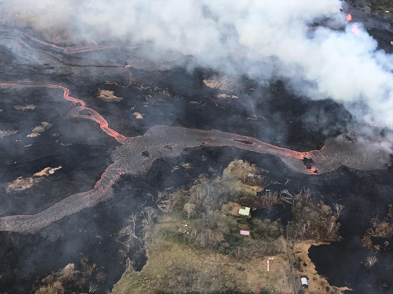
Volcanic gas emissions remain very high from the fissure eruptions.
For recent maps of activity, see: https://volcanoes.usgs.gov/volcanoes/kilauea/multimedia_maps.html
Additional ground cracking and outbreaks of lava in the area of the active fissures are possible. Residents downslope of the region of fissures should heed all Hawaii County Civil Defense messages and warnings.
Magma continues to be supplied to the lower East Rift Zone. Elevated earthquake activity continues, but earthquake locations have not moved farther downrift in the past couple of days. Only a few earthquakes located yesterday in the rift zone.
USGS/HVO continues to monitor the lower East Rift Zone activity 24/7 in coordination with Hawaii County Civil Defense. Geologists are onsite to track fissure activity and the advance of lava flows.
Kīlauea Volcano Summit
Small ash emissions from the Overlook crater have occurred frequently through the day. Moderate trade winds were blowing to the southwest today and ashfall may be noticed in downwind locations. A small explosion from overlook crater at 6:44 pm produced an ash cloud that reached 7000 feet above sea level as determined by the National Weather Service radar. The cloud did not contain much ash and dispersed quickly.
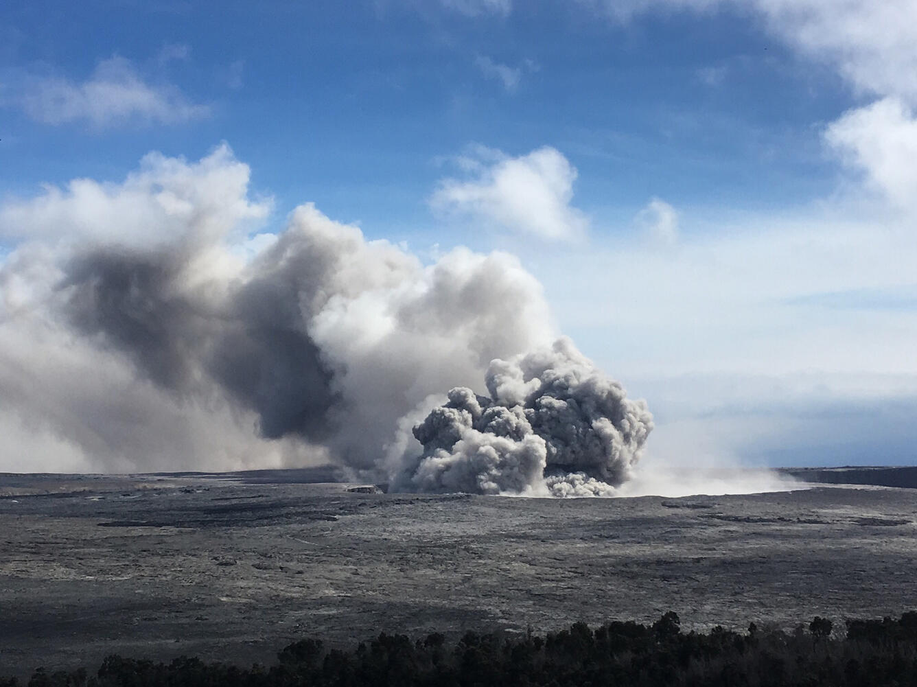
Earthquakes in the summit area continue at a moderate rate, as does deflation of the summit region. At 5:12pm the summit area was shaken by a shallow M3.5 earthquake approximately 0.7 miles below the caldera floor that was felt by people in the area. Many smaller earthquakes followed for the next 1.5 hours. The sequence of earthquakes stopped when an ash explosion occurred at 06:44 pm. The earthquakes and ash explosions are occurring as the summit area subsides and adjusts to the withdrawal of magma from the summit.
Additional explosive events that could produce minor amounts of ashfall downwind are possible at any time. Volcanic gas emissions at the summit remain high.
For forecasts of where ash would fall if such an explosion occur, please consult the Ash3D model output here: https://volcanoes.usgs.gov/observatories/hvo/activity_2018.html
Information on ash hazards and how to prepare for ashfall maybe found here: http://www.ivhhn.org/information#ash
MORE INFORMATION
Activity Summary also available by phone: (808) 967-8862
Subscribe to these messages: https://volcanoes.usgs.gov/vns2/
Webcam images: https://volcanoes.usgs.gov/volcanoes/kilauea/multimedia_webcams.html
Photos/Video: https://volcanoes.usgs.gov/volcanoes/kilauea/multimedia_chronology.html
Lava Flow Maps: https://volcanoes.usgs.gov/volcanoes/kilauea/multimedia_maps.html
Definitions of terms used in update: https://volcanoes.usgs.gov/volcanoes/kilauea/extra/definitions.pdf
Overview of Kīlauea summit (Halemaʻumaʻu) and East Rift Zone (Puʻu ʻŌʻō ) eruptions:
https://volcanoes.usgs.gov/volcanoes/kilauea/extra/background.pdf
Summary of volcanic hazards from Kīlauea eruptions:
https://volcanoes.usgs.gov/volcanoes/kilauea/extra/hazards.pdf
Recent Earthquakes in Hawai'i (map and list):
https://volcanoes.usgs.gov/hvo/earthquakes/
Explanation of Volcano Alert Levels and Aviation Color Codes:
https://volcanoes.usgs.gov/activity/alertsystem/index.php
https://pubs.usgs.gov/fs/2006/3139/
CONTACT INFORMATION:
askHVO@usgs.gov
The Hawaiian Volcano Observatory is one of five volcano observatories within the U.S. Geological Survey and is responsible for monitoring volcanoes and earthquakes in Hawai`i.
UPDATE, 5/23/18, 6:05am HST
Kīlauea Volcano Lower East Rift Zone
Eruption of lava and ground cracking continues in the area of Leilani Estates and Lanipuna Gardens subdivision.
The middle portion of the fissure system continues to produce the most robust eruptive activity in the Lower East Rift Zone. The most active fissures have been 22,19, 6, 5, and 23. A faint glow was seen from Fissure 9, but no flows, and methane was observed burning in road cracks overnight. The ocean entry remains active and is producing occasional small explosions. Observers noted the height of the perched lava pond / channel had reached 11 meters / 36 feet above the ground level.
Volcanic gas emissions remain very high from these fissure eruptions.
For recent maps of activity, see: https://volcanoes.usgs.gov/volcanoes/kilauea/multimedia_maps.html
Additional ground cracking and outbreaks of lava are possible in the area. Residents downslope of the region of fissures should heed all Hawaii County Civil Defense messages and warnings.
Magma continues to be supplied to the lower East Rift Zone. Elevated earthquake activity continues, but earthquake locations have not moved farther downrift in the past couple of days, and there were only a few earthquakes located yesterday in the rift zone.
USGS/HVO continues to monitor the lower East Rift Zone activity 24/7 in coordination with Hawaii County Civil Defense, with geologists onsite to track ongoing and new fissure activity and the advance of lava flows.
Kīlauea Volcano Summit
Small ash emissions from the Overlook crater occurred frequently throughout the night. Moderate trade winds were blowing to the southwest and ashfall may be noticed in downwind locations. Earthquakes in the summit area continue at a moderate rate, as does deflation of the summit region.
Additional explosive events that could produce minor amounts of ashfall downwind are possible at any time. Volcanic gas emissions at the summit remain high.
For forecasts of where ash would fall if such an explosion occur, please consult the Ash3D model output here: https://volcanoes.usgs.gov/observatories/hvo/activity_2018.html
Information on ash hazards and how to prepare for ashfall maybe found here: http://www.ivhhn.org/information#ash
UPDATE, 5/21/18, 10:22pm HST
Kīlauea Volcano Lower East Rift Zone
Eruption of lava and ground cracking continues in the area of Leilani Estates subdivision.
Over the course of the day, the most active eruptive activity in the Lower East Rift Zone shifted to the middle portion of the system of fissures. The most active fissures were 22,19, 6, 5, and 23. Fissure 17, at the northeastern end of the fissure system is only weakly active now. Fissure 6 is feeding a flow to the south, roughly parallel to the western flow from fissure 22. Fountaining of fissures 5 and 23 fed flows in the eastern part of Leilani Estates.
For recent maps of activity, see: https://volcanoes.usgs.gov/volcanoes/kilauea/multimedia_maps.html
Additional ground cracking and outbreaks of lava are possible in the area. Residents downslope of the region of fissures should heed all Count of Hawaii Civil Defense messages and warnings.
Magma continues to be supplied to the lower East Rift Zone. Elevated earthquake activity continues, but earthquake locations have not moved farther downrift in the past couple of days, and there were only a few earthquakes located today in the rift zone.
USGS/HVO continues to monitor the lower East Rift Zone activity 24/7 in coordination with Hawaii County Civil Defense, with geologists onsite to track ongoing and new fissure activity and the advance of lava flows.

Kīlauea Volcano Summit
Small ash emissions from the Overlook crater have been occurring frequently today. Moderate trade winds were blowing to the southwest and noticeable ashfall may happen in downwind locations.
Additional explosive events that could produce minor amounts of ashfall downwind are possible at any time. Volcanic gas emissions at the summit remain high.
For forecasts of where ash would fall if such an explosion occur, please consult the Ash3D model output here: https://volcanoes.usgs.gov/observatories/hvo/activity_2018.html
Information on ash hazards and how to prepare for ashfall maybe found here: http://www.ivhhn.org/information#ash

UPDATE, 5/21/18, 4:11pm HST
LOWER EAST RIFT ZONE
Moderate-level eruption of lava continues from multiple points along the northeast end of the active fissure system. Residents in lower Puna should remain informed and heed Hawaii County Civil Defense closures, warnings, and messages (http://www.hawaiicounty.gov/active-alerts)

Fissure 22 is erupting a short line of low lava fountains that feed a channelized flow that reaches the coast just north of MacKenzie State Park. Spattering continues from a reactivated Fissures 6 that intermittently feeds a short lava flow. Fissures 17 and 19 continue weak spattering.
HVO field crews are on site tracking the lava flows and spattering from multiple fissures as conditions allow and reporting information to Hawaii County Civil Defense.
For the most recent map showing the locations of activity, please see https://volcanoes.usgs.gov/volcanoes/kilauea/multimedia_maps.html These maps are updated as often as possible but may not reflect the most recent changes.
Volcanic gas emissions have tripled as a result of the voluminous eruptions from Fissure 20 so SO2 concentrations are likely elevated to higher levels throughout the area downwind of the vents. Moderate trade winds means that areas downwind of Kilauea gas emission sources may experience varying levels of vog. For forecast information, please see: http://mkwc.ifa.hawaii.edu/vmap/hysplit/

For other information about vog, please see:https://vog.ivhhn.org/
This eruption is still evolving and additional outbreaks of lava are possible. Ground deformation has slowed and seismicity levels have decrease in the area.
Future outbreaks could occur both uprift (southwest) and downrift (northeast) of the existing fissures, or, existing fissures can be reactivated. Communities downslope of these fissures could be at risk from lava inundation. Activity can change rapidly.
Conditions around the erupting fissures can change very quickly. Residents in lower Puna should remain informed and heed Hawaii County Civil Defense closures, warnings, and messages (http://www.hawaiicounty.gov/active-alerts).
KILAUEA SUMMIT
One explosive eruption of ash occurred at about 1 am, 5/21/18. Several smaller ash emissions have also taken place and produced abundant ash. Additional explosions possible at any time.
Seismic levels, which abruptly decreased after the recent explosive eruptions, are again slowly increasing.
At this time, based on HVO web cameras, a robust plume of gas and steam is billowing out of the Overlook vent and drifting generally southwest.
At any time, activity may again become more explosive, increasing the intensity of ash production and producing ballistic projectiles very near the vent. Communities downwind should be prepared for ashfall as long as this activity continues.
Resources on volcanic ash hazards and preparedness information: https://volcanoes.usgs.gov/volcanic_ash/ OR http://www.ivhhn.org/ash-protection
Resources on vog: https://vog.ivhhn.org/
National Weather Service ashfall information and advisories: https://forecast.weather.gov/
Seismicity and deformation continue at the Kilauea summit. Deflation is ongoing. Additional earthquakes in the Kilauea summit area are expected as long as the summit continues to deflate.
Current webcam views are here: https://volcanoes.usgs.gov/volcanoes/kilauea/multimedia_webcams.html

USGS/HVO continues to monitor the situation at the Kilauea summit and the lower East Rift Zone 24/7 in coordination with Hawaii County Civil Defense and other emergency authorities. HVO geologists are onsite in the area this morning conducting overflights, examining the fissure vent activity for significant changes, and searching for any signs of new or resumed activity.
Please see this link for newly organized information about ash hazards, gas hazards, and the Lower East Rift Zone eruption. https://vog.ivhhn.org/
UPDATE, 5/20/18, 2:15pm HST
LOWER EAST RIFT ZONE
Moderate-level eruption of lava continues from multiple points along the northeast end of the active fissure system. Residents in lower Puna should remain informed and heed Hawaii County Civil Defense closures, warnings, and messages (http://www.hawaiicounty.gov/active-alerts)
Spattering continues from Fissures 6 and 17 with significant lava flows being erupted from Fissures 20. Two of these lava flows from Fissure 20 reached the ocean along the southeast Puna coast overnight; however, a crack opened under the east lava channel early this morning diverting the lava from the channel into underground voids. This may cause changes downslope in the channel system and the ocean entry.

HVO field crews are on site tracking the lava flow and spattering from multiple fissures as conditions allow and reporting information to Hawaii County Civil Defense.
For the most recent map showing the locations of activity, please see https://volcanoes.usgs.gov/volcanoes/kilauea/multimedia_maps.html These maps are updated as often as possible but may not reflect the most recent changes.
Volcanic gas emissions have tripled as a result of the voluminous eruptions from Fissure 20 so SO2 concentrations are likely elevated to higher levels throughout the area downwind of the vents. Moderate trade winds today means that areas downwind of Kilauea gas emission sources may experience varying levels of vog. For forecast information, please see: http://mkwc.ifa.hawaii.edu/vmap/hysplit/
For other information about vog, please see:https://vog.ivhhn.org/
This eruption is still evolving and additional outbreaks of lava are possible. Ground deformation continues and seismicity remains elevated in the area.
Future outbreaks could occur both uprift (southwest) and downrift (northeast) of the existing fissures, or, existing fissures can be reactivated. Communities downslope of these fissures could be at risk from lava inundation. Activity can change rapidly.
Conditions around the erupting fissures can change very quickly. Residents in lower Puna should remain informed and heed Hawaii County Civil Defense closures, warnings, and messages (http://www.hawaiicounty.gov/active-alerts).
KILAUEA SUMMIT
Over the past day, two explosive eruption of ash have occurred. Several smaller ash emissions have also taken place. Additional explosions possible at any time.
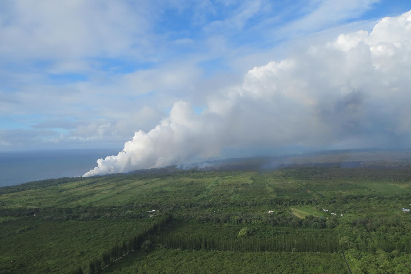
Seismic levels, which abruptly decreased after explosive eruptions on Saturday afternoon and Sunday noon, are again slowly increasing.
At this time, based on HVO web cameras, a robust plume of gas and steam is billowing out of the Overlook vent and drifting generally southwest.
At any time, activity may again become more explosive, increasing the intensity of ash production and producing ballistic projectiles very near the vent. Communities downwind should be prepared for ashfall as long as this activity continues.
Resources on volcanic ash hazards and preparedness information: https://volcanoes.usgs.gov/volcanic_ash/ OR http://www.ivhhn.org/ash-protection
Resources on vog: https://vog.ivhhn.org/
National Weather Service ashfall information and advisories: https://forecast.weather.gov/
Seismicity and deformation continue at the Kilauea summit. Deflation is ongoing. Additional earthquakes in the Kilauea summit area are expected as long as the summit continues to deflate.
Current webcam views are here: https://volcanoes.usgs.gov/volcanoes/kilauea/multimedia_webcams.html
USGS/HVO continues to monitor the situation at the Kilauea summit and the lower East Rift Zone 24/7 in coordination with Hawaii County Civil Defense and other emergency authorities. HVO geologists are onsite in the area this morning conducting overflights, examining the fissure vent activity for significant changes, and searching for any signs of new or resumed activity.
Please see this link for newly organized information about ash hazards, gas hazards, and the Lower East Rift Zone eruption. https://vog.ivhhn.org/
Hawaii County Civil Defense messages regarding conditions, warning, and evacuations may be found at http://www.hawaiicounty.gov/active-alerts/.

MORE INFORMATION
Activity Summary also available by phone: (808) 967-8862
Subscribe to these messages: https://volcanoes.usgs.gov/vns2/
Webcam images: https://volcanoes.usgs.gov/volcanoes/kilauea/multimedia_webcams.html
Photos/Video: https://volcanoes.usgs.gov/volcanoes/kilauea/multimedia_chronology.html
Lava Flow Maps: https://volcanoes.usgs.gov/volcanoes/kilauea/multimedia_maps.html
Definitions of terms used in update: https://volcanoes.usgs.gov/volcanoes/kilauea/extra/definitions.pdf
Overview of Kīlauea summit (Halemaʻumaʻu) and East Rift Zone (Puʻu ʻŌʻō ) eruptions:
https://volcanoes.usgs.gov/volcanoes/kilauea/extra/background.pdf
Summary of volcanic hazards from Kīlauea eruptions:
https://volcanoes.usgs.gov/volcanoes/kilauea/extra/hazards.pdf
Recent Earthquakes in Hawai'i (map and list):
https://volcanoes.usgs.gov/hvo/earthquakes/
Explanation of Volcano Alert Levels and Aviation Color Codes:
https://volcanoes.usgs.gov/activity/alertsystem/index.php
https://pubs.usgs.gov/fs/2006/3139/

CONTACT INFORMATION:
askHVO@usgs.gov
The Hawaiian Volcano Observatory is one of five volcano observatories within the U.S. Geological Survey and is responsible for monitoring volcanoes and earthquakes in Hawai`i.
UPDATE, 5/19/18, 9:16am HST
Kīlauea Volcano Lower East Rift Zone
Eruption of lava and ground cracking in the area of Leilani Estates subdivision continues.
Beginning yesterday and continuing overnight, the rate of lava eruption has increased. Fountaining is occurring at Fissure 17, and Fissures 16-20 have merged into a continuous line of spatter and fountaining. Flows from the consolidated Fissure 20 crossed upper Pohoiki road late yesterday afternoon and continued flowing southward. This morning, the wide flow is very active and is advancing at rates up to 300 yds per hour. A second flow from the same fissure complex is also flowing southward between Pohoiki and Opihikao Rds. The lava flow from Fissure 18 continues to advance more slowly. Fissure 17 and its flow are still active but the flow is advancing even more slowly. It is unknown whether the flows will continue to advance, or stop, and new lava flows are likely given the rate of activity seen at the rift zone.
For recent maps of activity, see: https://volcanoes.usgs.gov/volcanoes/kilauea/multimedia_maps.html.
Additional ground cracking and outbreaks of lava are possible in the area. Residents downslope of the region of fissures should heed all Count of Hawaii Civil Defense messages and warnings.
Magma continues to be supplied to the lower East Rift Zone; however, the GPS instrument near Pu`u Honua`ula is no longer moving suggesting that the rift zone is no longer inflating in this area. Elevated earthquake activity continues, but earthquake locations have not moved farther downrift in the past couple of days.
USGS/HVO continues to monitor the lower East Rift Zone activity 24/7 in coordination with Hawaii County Civil Defense, with geologists onsite to track ongoing and new fissure activity and the advance of lava flows.
Kīlauea Volcano Summit
An explosion occurred around midnight last night at Halema'uma'u with the plume extending 10,000 ft a.s.l. Moderate trade winds were blowing to the southwest and noticeable ashfall was reported from downwind locations.
Additional explosive events that could produce minor amounts of ashfall downwind are possible at any time. Volcanic gas emissions at the summit remain high.
- For forecasts of where ash would fall if such an explosion occur, please consult the Ash3D model output here: https://volcanoes.usgs.gov/observatories/hvo/activity_2018.html.
- Information on ash hazards and how to prepare for ashfall maybe found here: http://www.ivhhn.org/information#ash.
UPDATE, 5/19/18, 1:33am HST
Kīlauea Volcano Summit
At 11:58 PM Local time, a short-lived explosion at from Halema'uma'u created an ash cloud that reached up to 10,000 ft asl and was carried southwest by the wind. Possible trace ash fall may have occurred along Highway 11.
Additional explosive events that could produce minor amounts of ashfall downwind are possible at any time. Volcanic gas emissions at the summit remain high. For forecasts of where ash would fall if such an explosion occur, please consult the Ash3D model output here: https://volcanoes.usgs.gov/observatories/hvo/activity_2018.html.
Information on ash hazards and how to prepare for ashfall maybe found here: http://www.ivhhn.org/information#ash.
Kīlauea Volcano Lower East Rift Zone
Eruption of lava and ground cracking in the area of Leilani Estates subdivision continues. A fast-moving pahoehoe lava flow that emerged from fissure 20 this afternoon continues to flow southeast. The flow has three main lobes. The easternmost is east of Pohoiki Road and is moving about 230 yards per hour. The westernmost of the lobes is near Malamaki Road and is moving at about 40 yards per hour. These rates may change with time and USGS crews are in the area to monitor flow advance. Other fissures remain weakly active and volcanic gas emissions remain elevated throughout the area downwind. Smoke from burning vegetation as lava flows advance is also contributing to poor air quality.
For recent maps of activity, see: https://volcanoes.usgs.gov/volcanoes/kilauea/multimedia_maps.html.
Additional ground cracking and outbreaks of lava are possible in the area. Residents downslope of the region of fissures should heed all Count of Hawaii Civil Defense messages and warnings.
Magma continues to be supplied to the lower East Rift Zone as indicated by the continued northwest displacement of a GPS monitoring station. Elevated earthquake activity continues, but earthquake locations have not moved farther downrift in the past couple of days.
USGS/HVO continues to monitor the lower East Rift Zone activity 24/7 in coordination with Hawaii County Civil Defense, with geologists onsite to track ongoing and new fissure activity and the advance of lava flows.
UPDATE, 5/18/18, 7:53pm HST

Kīlauea Volcano Lower East Rift Zone
Eruption of lava and ground cracking in the area of Leilani Estates subdivision continues. Late this afternoon, a fast-moving pahoehoe lava flow emerged from fissure 20 and traveled southeast where it crossed Pohoiki Road. Estimates from Hawaii County Fire Department aerial video at 6:30 pm indicate advance rate of 300-400 yards per hour; this rate may change with time and USGS crews are in the area to try and monitor flow advance. Other fissures remain weakly active and volcanic gas emissions remain elevated throughout the area downwind. Smoke from burning vegetation as lava flows advance is also contributing to poor air quality.
For recent maps of activity, see: https://volcanoes.usgs.gov/volcanoes/kilauea/multimedia_maps.html.
Additional ground cracking and outbreaks of lava are possible in the area. Residents downslope of the region of fissures should heed all Count of Hawaii Civil Defense messages and warnings.
Magma continues to be supplied to the lower East Rift Zone as indicated by the continued northwest displacement of a GPS monitoring station. Elevated earthquake activity continues, but earthquake locations have not moved farther downrift in the past couple of days.
USGS/HVO continues to monitor the lower East Rift Zone activity 24/7 in coordination with Hawaii County Civil Defense, with geologists onsite to track ongoing and new fissure activity and the advance of lava flows.
Kīlauea Volcano Summit
For much of the day, a steady, white steam plume rose from the Overlook vent within Halema'uma'u. Several minor emissions of ash were observed in web cameras. No significant explosions and no earthquakes greater than magnitude 3.5 have occurred in the summit area in the past 24 hours. Background seismic levels have been increasing slowly over the course of the day.
Additional explosive events that could produce minor amounts of ashfall downwind are possible at any time. Volcanic gas emissions at the summit remain high. For forecasts of where ash would fall if such an explosion occurs, please consult the Ash3D model output here: https://volcanoes.usgs.gov/observatories/hvo/activity_2018.html.
Information on ash hazards and how to prepare for ashfall maybe found here: http://www.ivhhn.org/information#ash.
UPDATE, 5/18/18, 8:52am HST
Please see this new section of the HVO web site for information on the ongoing activity at Kilauea Volcano: https://volcanoes.usgs.gov/observatories/hvo/activity_2018.html.
LOWER EAST RIFT ZONE
- Moderate-level eruption of lava continues from multiple points along the central and northeast end of the active fissure system. Residents in lower Puna should remain informed and heed Hawaii County Civil Defense closures, warnings, and messages: http://www.hawaiicounty.gov/active-alerts.
- Spattering continues from Fissures 15, 17, 18, 20, 21, and 22 with pahoehoe lava flows being erupted from Fissures 17, 18, and 20.
- HVO field crews are on site tracking the lava flow and spattering from multiple fissures as conditions allow and reporting information to Hawaii County Civil Defense.
- For the most recent map showing the locations of activity, please see https://volcanoes.usgs.gov/volcanoes/kilauea/multimedia_maps.html. These maps are updated as often as possible but may not reflect the most recent changes.
- Volcanic gas emissions remain elevated throughout the area downwind of the vents. Weak winds today means that other areas of Hawaii Island may experience varying levels of vog. For forecast information, please see: http://mkwc.ifa.hawaii.edu/vmap/hysplit/. For other information about vog, please see: https://vog.ivhhn.org/.
- This eruption is still evolving and additional outbreaks of lava are possible. Ground deformation continues and seismicity remains elevated in the area.
- Future outbreaks could occur both uprift (southwest) and downrift (northeast) of the existing fissures, or, existing fissures can be reactivated. Communities downslope of these fissures could be at risk from lava inundation. Activity can change rapidly.
- Conditions around the erupting fissures can change very quickly. Residents in lower Puna should remain informed and heed Hawaii County Civil Defense closures, warnings, and messages: http://www.hawaiicounty.gov/active-alerts.
KILAUEA SUMMIT
- No explosive eruption of ash have occurred since Thursday morning. Additional explosions possible at any time.
- Seismic levels, which abruptly decreased after explosive eruptions on Wednesday night and early Thursday morning, are slowly increasing.
- At this time, based on HVO web cameras, a robust plume of gas and steam is billowing out of the Overlook vent and drifting generally southwest.
- At any time, activity may again become more explosive, increasing the intensity of ash production and producing ballistic projectiles very near the vent. Communities downwind should be prepared for ashfall as long as this activity continues.
- Resources on volcanic ash hazards and preparedness information: https://volcanoes.usgs.gov/volcanic_ash/ OR http://www.ivhhn.org/ash-protection.
- National Weather Service ashfall information and advisories: https://forecast.weather.gov/.
- Seismicity and deformation continue at the Kilauea summit. Deflation is ongoing. Additional earthquakes in the Kilauea summit area are expected as long as the summit continues to deflate.
- Current webcam views are here: https://volcanoes.usgs.gov/volcanoes/kilauea/multimedia_webcams.html.
REMARKS
- USGS/HVO continues to monitor the situation at the Kilauea summit and the lower East Rift Zone 24/7 in coordination with Hawaii County Civil Defense and other emergency authorities. HVO geologists are onsite in the area this morning conducting overflights, examining the fissure vent activity for significant changes, and searching for any signs of new or resumed activity.
- Please see this link for newly organized information about ash hazards, gas hazards, and the Lower East Rift Zone eruption: https://vog.ivhhn.org/.
- Hawaii County Civil Defense messages regarding conditions, warning, and evacuations may be found at http://www.hawaiicounty.gov/active-alerts/.
UPDATE, 5/17/18, 4:54pm HST
Kīlauea Volcano Summit
- After the explosive eruption early this morning seismic levels have been gradually increasing, but as of this report no additional explosions have occurred.
- No earthquakes greater than magnitude 3.5 have occurred in the past day.
- Volcanic gas emissions at the summit remain high.
Kīlauea Lower East Rift Zone
- This afternoon, fissure 17 is still actively spattering but the flow is nearly stalled. In addition, fissures 18, 19, and 20 have reactivated and a new fissure (21) has opened between fissures 7 and 3. An area 50-100 yards wide, parallel to and north of the line of fissures between Highway 130 and Lanipuna Gardens, has dropped slightly. This long depression is currently being filled by pahoehoe lava flows from fissures 20 and 21.
- Volcanic gas emissions remain elevated throughout the area downwind of the fissures.
- Magma continues to be supplied to the lower East Rift Zone as indicated by the continued northwest displacement of a GPS monitoring station. Elevated earthquake activity continues, but earthquake locations have not moved farther downrift in the past couple of days.
- USGS/HVO continues to monitor the lower East Rift Zone activity 24/7 in coordination with Hawaii County Civil Defense, with geologists onsite to track ongoing and new fissure activity and the advance of lava flows.
UPDATE, 5/17/18, 10:40am HST
LOWER EAST RIFT ZONE
Low-level eruption of lava continues from multiple points along the northeast end of the active fissure system. Residents in lower Puna should remain informed and heed Hawaii County Civil Defense closures, warnings, and messages: http://www.hawaiicounty.gov/active-alerts.
Spattering continues from Fissure 17 but the lava flow erupted from the fissure has not advanced significantly over the past day.
HVO field crews are on site tracking the lava flow and spattering from multiple fissures as conditions allow and reporting information to Hawaii County Civil Defense.
For the most recent map showing the locations of activity, please see https://volcanoes.usgs.gov/volcanoes/kilauea/multimedia_maps.html. These maps are updated as often as possible but may not reflect the most recent changes.
Volcanic gas emissions remain elevated throughout the area downwind of the vents. Weak winds today means that other areas of Hawaii Island may experience varying levels of vog. For forecast information, please see: http://mkwc.ifa.hawaii.edu/vmap/hysplit/
For other information about vog, please see: https://vog.ivhhn.org/.
This eruption is still evolving and additional outbreaks of lava are possible. Ground deformation continues and seismicity remains elevated in the area.
Future outbreaks could occur both uprift (southwest) and downrift (northeast) of the existing fissures, or, existing fissures can be reactivated. Communities downslope of these fissures could be at risk from lava inundation. Activity can change rapidly.
Conditions around the erupting fissures can change very quickly. Residents in lower Puna should remain informed and heed Hawaii County Civil Defense closures, warnings, and messages: http://www.hawaiicounty.gov/active-alerts.
KILAUEA SUMMIT
Explosive eruption of ash this morning. Additional explosions possible at any time.
Just after 4 am this morning, an explosion or series of explosions from the Overlook vent within Halemaumau crater at Kilauea Volcano's summit produced a volcanic cloud that reached as high as 30,000 ft asl based on NWS radar information. The cloud drifted generally northeast and traces of ash fell with rain in the Volcano Golf Course, Volcano Village, and other areas immediately around the Kilauea summit.
At this time, based on HVO web cameras, a robust plume of gas, steam, and some ash is billowing out of the Overlook vent and drifting generally southwest.
At any time, activity may again become more explosive, increasing the intensity of ash production and producing ballistic projectiles very near the vent. Communities downwind should be prepared for ashfall as long as this activity continues.
- Resources on volcanic ash hazards and preparedness information: https://volcanoes.usgs.gov/volcanic_ash/ OR http://www.ivhhn.org/ash-protection.
- National Weather Service ashfall information and advisories: https://forecast.weather.gov/.
Seismicity and deformation continue at the Kilauea summit. Deflation is ongoing. Additional earthquakes in the Kilauea summit area are expected as long as the summit continues to deflate.
- Current webcam views are here: https://volcanoes.usgs.gov/volcanoes/kilauea/multimedia_webcams.html.
REMARKS
USGS/HVO continues to monitor the situation at the Kilauea summit and the lower East Rift Zone 24/7 in coordination with Hawaii County Civil Defense and other emergency authorities. HVO geologists are onsite in the area this morning conducting overflights, examining the fissure vent activity for significant changes, and searching for any signs of new or resumed activity.
- Please see this link for newly organized information about ash hazards, gas hazards, and the Lower East Rift Zone eruption: https://vog.ivhhn.org/.
- Hawaii County Civil Defense messages regarding conditions, warning, and evacuations may be found at http://www.hawaiicounty.gov/active-alerts/.
UPDATE, 5/17/18, 6:33am HST
Volcanic Activity Summary: At about 0415 local time this morning, an explosion from the Overlook vent within Halemaumau crater at Kilauea Volcano's summit produced a volcanic cloud that reaches as high as 30,000 ft asl and drifted northeast. Continued emissions from the crater are reaching as high as 12,000 ft asl.
At any time, activity may again become more explosive, increasing the intensity of ash production and producing ballistic projectiles near the vent.
- Resource on volcanic ash hazards: https://volcanoes.usgs.gov/volcanic_ash/
- Resource on vog: https://vog.ivhhn.org/
- Current NWS information on ashfall: http://www.prh.noaa.gov/hnl/watchwarn/
Recent Observations:
- Volcanic cloud height up to 30,000 ft asl
- Other volcanic cloud information: Drifting generally northeast
Hazard Analysis:
- The ash cloud is drifting downwind to the northeast.
- Ashfall has been reported in Volcanoes National Park, and may occur further downwind.
- Ballistic projectiles may be produced should steam-driven explosions occur. Impacts will be limited to an area around Halemaumau.
- Volcanic gas: Vog or volcanic air pollution produced by volcanic gas has been reported in Pahala.
Remarks: Photos of this activity may be found here: https://volcanoes.usgs.gov/volcanoes/kilauea/kilauea_multimedia_15.html
UPDATE, 5/16/18, 8:52am HST
LOWER EAST RIFT ZONE
Low-level eruption of lava continues from multiple points along the northeast end of the active fissure system. Residents in lower Puna should remain informed and heed Hawaii County Civil Defense closures, warnings, and messages: http://www.hawaiicounty.gov/active-alerts.
Lava flows from fissure 17 have advanced little over the past day. Field crew estimates are an advance of only 100 yards.
HVO field crews are on site tracking the lava flow and spattering from multiple fissures as conditions allow and reporting information to Hawaii County Civil Defense.
For the most recent map showing the locations of activity, please see https://volcanoes.usgs.gov/volcanoes/kilauea/multimedia_maps.html. These maps are updated as often as possible but may not reflect the most recent changes.
Volcanic gas emissions remain elevated throughout the area downwind of the vents. An interruption in trade winds today means that other areas of Hawaii Island may experience varying levels of vog. For forecast information, please see: http://mkwc.ifa.hawaii.edu/vmap/hysplit/.
For other information about vog, please see: https://vog.ivhhn.org/.
This eruption is still evolving and additional outbreaks of lava are possible. Ground deformation continues and seismicity remains elevated in the area.
Future outbreaks could occur both uprift (southwest) and downrift (northeast) of the existing fissures, or, existing fissures can be reactivated. Communities downslope of these fissures could be at risk from lava inundation. Activity can change rapidly.
Conditions around the erupting fissures can change very quickly. Residents in lower Puna should remain informed and heed Hawaii County Civil Defense closures, warnings, and messages: http://www.hawaiicounty.gov/active-alerts.
KILAUEA SUMMIT
Yesterday, ash emissions from the Overlook vent inside Halemaumau varied greatly in intensity with abrupt increases likely associated with large rockfalls deep into the vent. A number of these periods of increased ash emission sent plumes as high as 10,000 feet above sea level, with the cloud drifting downwind and dusting communities from Pahala to Discovery Harbor with ash. Yesterday's ash clouds were visible from many vantage points in east Hawaii. Because of the increase in ash emission and higher altitudes of ash, HVO assigned an aviation color code RED to indicated significant ash emission that is a hazard to aircraft. We are remaining at RED this morning anticipating further ash events which may continue for the foreseeable future. Communities downwind should expect intermittent ashfall.
This morning dense ballistic blocks up to 60 cm (2 feet) across were found in the parking lot a few hundred yards from Halemaumau. These reflect the most energetic explosions yet observed and could reflect the onset of steam-driven explosive activity. Further observations are necessary to asses this interpretation. Additional such explosions are expected and could be more powerful.
Seismicity and deformation continue at the Kilauea summit. Deflation is ongoing. Several strongly felt earthquakes have occurred over the past day, likely caused by ongoing deflation of the summit area. These are expected to continue.
Current webcam views are here: https://volcanoes.usgs.gov/volcanoes/kilauea/multimedia_webcams.html.
For information on ash hazards and how to mitigate impacts please see: http://www.ivhhn.org/ash-protection.
REMARKS
USGS/HVO continues to monitor the situation at the Kilauea summit and the lower East Rift Zone 24/7 in coordination with Hawaii County Civil Defense and other emergency authorities. HVO geologists are onsite in the area this morning conducting overflights, examining the fissure vent activity for significant changes, and searching for any signs of new or resumed activity.
Please see this link for newly organized information about ash hazards, gas hazards, and the Lower East Rift Zone eruption. https://vog.ivhhn.org/.
Hawaii County Civil Defense messages regarding conditions, warning, and evacuations may be found at http://www.hawaiicounty.gov/active-alerts/.
UPDATE, 5/15/18, 1:23pm HST
HVO/USGS Volcanic Activity Notice: Aviation Color Code changed from ORANGE to RED
Volcano: Kilauea (VNUM #332010)
Current Volcano Alert Level: WARNING
Current Aviation Color Code: RED
Previous Aviation Color Code: ORANGE
Issued: Tuesday, May 15, 2018, 1:23 PM HST
Source: Hawaiian Volcano Observatory
Notice Number:
Location: N 19 deg 25 min W 155 deg 17 min
Elevation: 4091 ft (1247 m)
Area: Hawaii
Volcanic Activity Summary: As of early this morning, eruption of ash from the Overlook vent within Halemaumau crater at Kilauea Volcano's summit has generally increased in intensity. Ash has been rising nearly continuously from the vent and drifting downwind to the southwest. Ashfall and vog (volcanic air pollution) has been reported in Pahala, about 18 miles downwind. NWS radar and pilot reports indicate the top of the ash cloud is as high as 10,000 to 12,000 feet above sea level, but this may be expected to vary depending on the vigor of activity and wind conditions.
Ash emission from the Kilauea summit vent will likely be variable with periods of increased and decreased intensity depending on the occurrence of rockfalls into the vent and other changes within the vent.
At any time, activity may become more explosive, increasing the intensity of ash production and producing ballistic projectiles near the vent.
Resource on volcanic ash hazards: https://volcanoes.usgs.gov/volcanic_ash/
Resource on vog: https://vog.ivhhn.org/
Recent Observations:
[Volcanic cloud height] 10,000 - 12,000 feet
[Other volcanic cloud information] Drifting generally southwest with tradewinds.
Hazard Analysis:
[Ash cloud] The ashcloud is drifting downwind primarily to the southwest with the Trade Winds. Wind conditions are expected to change in the next 24 hours and other areas around Kilauea's summit are likely to receive ashfall.
[Ashfall] Ashfall has been reported in the community of Pahala, at locations along Highway 11 from Pahala to Volcano, and in the Ka'u Desert section of Hawaii Volcanoes National Park.
[Other hazards] Ballistic projectiles may be produced should steam-driven explosions occur. Impacts will be limited to an area around Halemaumau.
[Volcanic gas] Vog or volcanic air pollution produced by volcanic gas has been reported in Pahala.
Remarks: Photos of this activity may be found at https://volcanoes.usgs.gov/volcanoes/kilauea/kilauea_multimedia_15.html
UPDATE, 5/15/18, 12:28pm HST
Kīlauea Lower East Rift Zone
This morning, eruptive activity remained concentrated at fissure 17, with intermittent lava spattering at fissure 18. Earlier this morning, a new fissure (20) located near fissure 18 produced two small pads of lava. The 'a'ā flow spreading from fissure 17 advanced about 380 m (1,250 ft) since 2:30 p.m. HST yesterday. The advance of the flow has slowed significantly since yesterday afternoon. At 6:45 a.m. the flow was nearly 2.5 km (1.5 mi) in length.
Volcanic gas emissions remain elevated throughout the area downwind of the fissures.
Magma continues to be supplied to the lower East Rift Zone as indicated by the continued northwest displacement of a GPS monitoring station. Elevated earthquake activity continues, but earthquake locations have not moved farther downrift in the past couple of days.
USGS/HVO continues to monitor the lower East Rift Zone activity 24/7 in coordination with Hawaii County Civil Defense, with geologists onsite to track ongoing and new fissure activity and the advance of lava flows.
UPDATE, 5/15/18, 9:41am HST
Kīlauea Volcano Summit
Ash emission from the Overlook crater within Halemaumau has generally increased this morning compared to previous days. Although varying in intensity, at times the plume contains enough ash to be gray in color. The cloud is rising an estimated 3 to 4,000 feet above the ground, but altitudes are varying with pulses of emission. The ash cloud is drifting generally west and southwest from the Kilauea summit and ashfall is occurring in the Ka'u Desert. Communities downwind are likely to receive ashfall today and should take necessary precautions.
The National Weather Service has issued a Special Weather Statement regarding ashfall, please see: http://www.prh.noaa.gov/hnl/.
For information on the hazards of volcanic ash and how to prepare your home or business, please see https://volcanoes.usgs.gov/volcanic_ash/.
Earthquake activity in the summit remains elevated with several strongly felt events at HVO today. Most of these earthquakes are related to the ongoing subsidence of the summit area and earthquakes beneath the south flank of the volcano.
For information on volcanic ash, please see https://volcanoes.usgs.gov/volcanic_ash/.
UPDATE, 5/14/18, 8:36am HST
LOWER EAST RIFT ZONE
Eruption of lava continues from multiple points along the northeast end of the active fissure system. Residents in lower Puna should remain informed and heed Hawaii County Civil Defense closures, warnings, and messages (http://www.hawaiicounty.gov/active-alerts)
This morning, activity is dominated by lava fountaining, explosion of spatter more than 100 feet into the air, and an advancing lava flow from fissure 17 at the northeast end of the fissure system. As of 630am HST, the fissure 17 flow had traveled just under a mile roughly east-southeast parallel to the rift zone. It is turning slightly south and at this time is about one half mile south of Highway 132.
Fissure 18 that became active late yesterday (5/13/18) is weakly active.
A fissure 19 has been spotted very near fissure 15 as of about 8 am just northeast of Pohoiki Road and north of Hinalo Street at the east end of Lanipuna Gardens. It is producing a sluggish lava flow.
Volcanic gas emissions remain elevated throughout the area downwind of the vents. Yesterday with the onset of activity at fissure 17, powerful steam jets have occurred intermittently near the west end of the fissure. These jets may be responsible for some of the loud sounds reported by residents and emergency workers.
For the most recent map showing the locations of activity, please see https://volcanoes.usgs.gov/volcanoes/kilauea/multimedia_maps.html
HVO field crews are on site tracking the lava flow as conditions allow and reporting information to Hawaii County Civil Defense.
This eruption is still evolving and additional outbreaks of lava are possible. Ground deformation continues and seismicity remains elevated in the area.
The location of future outbreaks could include areas both uprift (southwest) and downrift (northeast) of the existing fissures, or, existing fissures can be reactivated. Communities downslope of these fissures could be at risk from lava inundation. Activity can change rapidly.
Conditions around the erupting fissures can change very quickly. Residents in lower Puna should remain informed and heed Hawaii County Civil Defense closures, warnings, and messages (http://www.hawaiicounty.gov/active-alerts).
KILAUEA SUMMIT
Deflationary tilt at the summit of the volcano continues and seismicity remains elevated. Last night several strong earthquakes shook HVO and the surrounding area.
This morning, a steady, vigorous plume of steam and occasionally minor amounts of ash is rising from the Overlook vent and drifting downwind to the southwest. As has been observed over the past several days, occasional rockfalls into the deep vent are expected produce intermittent pulses of slightly more vigorous ash emissions. Depending on wind conditions, dustings of ash may occur in the Kilauea summit area and downwind. More energetic ash emissions are possible if explosive activity commences.
Current webcam views are here: https://volcanoes.usgs.gov/volcanoes/kilauea/multimedia_webcams.html
USGS/HVO continues to monitor the situation at the summit and the lower East Rift Zone 24/7 in coordination with Hawaii County Civil Defense and other emergency authorities. HVO geologists are onsite in the area this morning conducting overflights, examining the fissure vent activity for significant changes, and searching for any signs of new or resumed activity.
Please see this link for newly organized information about ash hazards, gas hazards, and the Lower East Rift Zone eruption. https://vog.ivhhn.org/
Hawaii County Civil Defense messages regarding conditions, warning, and evacuations may be found at http://www.hawaiicounty.gov/active-alerts/.
UPDATE, 5/13/18, 8:28pm HST
Lower East Rift Zone Eruption
Eruption of lava continues from the northeast end of the active fissure system. Residents in lower Puna should remain informed and heed Hawaii County Civil Defense closures, warnings, and messages (http://www.hawaiicounty.gov/active-alerts).
As of late May 13th, activity was dominated by lava fountaining, explosion of spatter bombs hundreds of feet into the air, and several advancing lava flow lobes moving generally northeast from fissure 17 at the downrift (northeast) end of the new fissure system. As of about 7 pm, one lobe was 2 yards thick and advancing roughly parallel to Highway 132. The flow front was just over a half mile southeast of the intersection of Highway 132 and Noni Farms Road.
Based on overflight images late this afternoon, additional lava from fissure 17 was also moving slowly southeast. Volcanic gas emissions remain elevated.
For the most recent map showing the locations of activity, please see https://volcanoes.usgs.gov/volcanoes/kilauea/multimedia_maps.html
HVO field crews are on site tracking the lava flow as conditions allow and reporting information to Hawaii County Civil Defense.
This eruption is still evolving and additional outbreaks of lava are possible. The location of future outbreaks could include areas both uprift (southwest) and downrift (northeast) of the existing fissures, or, existing fissures can be reactivated. Communities downslope of these fissures could be at risk from lava inundation. Activity can change rapidly.
For information on volcanic air pollution, please see: http://www.ivhhn.org/vog/
Kīlauea Volcano Summit
Deflationary tilt continues. A robust plume of steam and volcanic gas, occasionally mixed with ash, has risen from the Overlook crater within Halemaumau. Over the course of the day, rockfalls from the steep walls enclosing the Overlook crater generated ash clouds mixed with steam and gas intermittently throughout the day. These ash clouds have been relatively low concentration and have risen at most only a few thousand feet above the ground, a few generating very localized ashfall downwind. More explosive activity generating larger ash clouds remains possible and can occur with no warning.
Earthquake activity in the summit remains elevated with several strongly felt events at HVO today. Most of these earthquakes are related to the ongoing subsidence of the summit area and earthquakes beneath the south flank of the volcano.
For information on volcanic ash, please see: https://volcanoes.usgs.gov/volcanic_ash/
MORE INFORMATION
Activity Summary also available by phone: (808) 967-8862
Subscribe to these messages: https://volcanoes.usgs.gov/vns2/
Webcam images: https://volcanoes.usgs.gov/volcanoes/kilauea/multimedia_webcams.html
Photos/Video: https://volcanoes.usgs.gov/volcanoes/kilauea/multimedia_chronology.html
Lava Flow Maps: https://volcanoes.usgs.gov/volcanoes/kilauea/multimedia_maps.html
Definitions of terms used in update: https://volcanoes.usgs.gov/volcanoes/kilauea/extra/definitions.pdf
Overview of Kīlauea summit (Halemaʻumaʻu) and East Rift Zone (Puʻu ʻŌʻō ) eruptions:
https://volcanoes.usgs.gov/volcanoes/kilauea/extra/background.pdf
Summary of volcanic hazards from Kīlauea eruptions:
https://volcanoes.usgs.gov/volcanoes/kilauea/extra/hazards.pdf
Recent Earthquakes in Hawai'i (map and list):
https://volcanoes.usgs.gov/hvo/earthquakes/
Explanation of Volcano Alert Levels and Aviation Color Codes:
https://volcanoes.usgs.gov/activity/alertsystem/index.php
https://pubs.usgs.gov/fs/2006/3139/
CONTACT INFORMATION:
askHVO@usgs.gov
The Hawaiian Volcano Observatory is one of five volcano observatories within the U.S. Geological Survey and is responsible for monitoring volcanoes and earthquakes in Hawai`i.
UPDATE, 5/13/18, 8:25am HST
LOWER EAST RIFT ZONE
Eruption of lava continues along Kilauea Volcano's lower East Rift Zone. A new outbreak early this morning just over a half mile northeast of the end of Hinalo St. and about one half mile south of highway 132 has been confirmed. Hawaii County Civil Defense reports the outbreak is on Halekamahina Loop Road. Aerial observations of this new fissure indicate it is at least several hundreds yards long and producing spatter rising many tens of feet into the air. A slow-moving lava flow is moving away from the vent.
Elevated earthquake activity and ground deformation continue and additional outbreaks in the area remain likely.
Conditions around the erupting fissures can change very quickly. Residents in lower Puna should remain informed and heed Hawaii County Civil Defense closures, warnings, and messages (http://www.hawaiicounty.gov/active-alerts).
KILAUEA SUMMIT
Deflationary tilt at the summit of the volcano continues and seismicity remains elevated. This morning, a steady, vigorous plume of steam and occasionally minor amounts of ash is rising from the Overlook vent and drifting downwind to the southwest. As has been observed over the past several days, occasional rockfalls into the deep vent are expected produce intermittent pulses of slightly more vigorous ash emissions. Depending on wind conditions, dustings of ash may occur in the Kilauea summit area and downwind. More energetic ash emissions are possible if explosive activity commences.
Current webcam views are here: https://volcanoes.usgs.gov/volcanoes/kilauea/multimedia_webcams.html
USGS/HVO continues to monitor the situation at the summit and the lower East Rift Zone 24/7 in coordination with Hawaii County Civil Defense and other emergency authorities. HVO geologists are onsite conducting overflights, examining the fissure vent activity for significant changes, and searching for any signs of new or resumed activity.
Please see this link for newly organized information about ash hazards, gas hazards, and the Lower East Rift Zone eruption. https://vog.ivhhn.org/
UPDATE, 5/12/18, 7:07pm HST

Lower East Rift Zone Eruption
A new outbreak has been reported at 6:00 pm (5/12/18) just east of fissure 16. Lava from this latest outbreak is actively spattering and degassing but no flow has yet formed. This area was actively steaming earlier in the day. The new fissure (17) is about a half mile northeast from the end of Hinalo Road, very close to fissure 16 that opened about 6:45 am. Activity at fissure 16 produced a lava flow that traveled about 250 yards before stalling about 2:30 pm.
HVO field crews are on site and evaluating the new outbreak.
Earthquake activity, ground deformation, and continuing high emission rates of sulphur dioxide in the area indicate additional outbreaks of lava are likely as this eruption continues. The location of future outbreaks could include areas both uprift (southwest) and downrift (northeast) of the existing fissures, or, existing fissures can be reactivated. Communities downslope of these fissures could be at risk from lava inundation.
Residents in lower Puna should remain informed and heed Hawaii County Civil Defense closures, warnings, and messages (http://www.hawaiicounty.gov/active-alerts).
For maps showing the locations of activity, please see https://volcanoes.usgs.gov/volcanoes/kilauea/multimedia_maps.html
For information on volcanic air pollution, please see: http://www.ivhhn.org/vog/
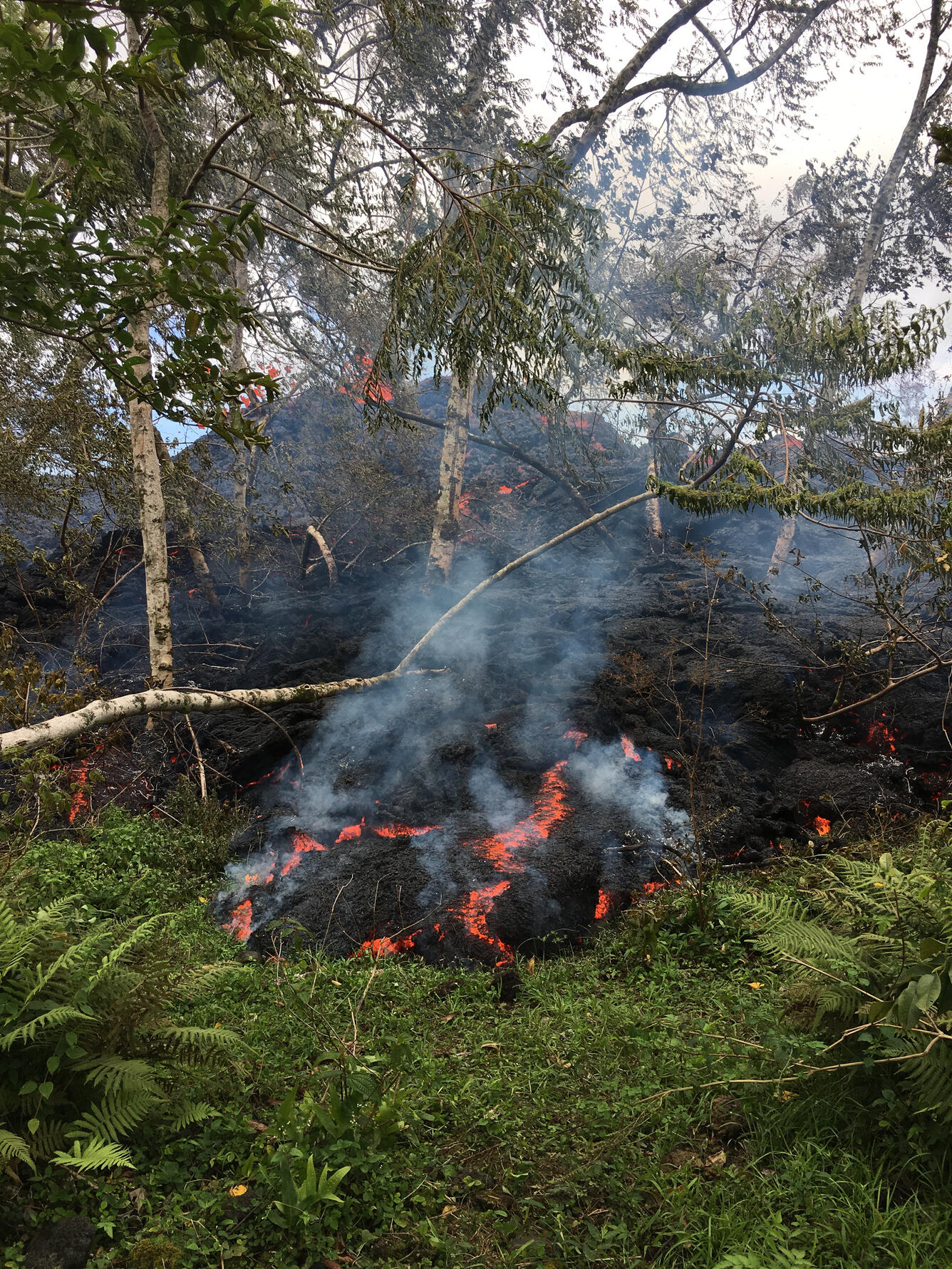
Kīlauea Volcano Summit
Deflationary tilt continues. Based on this and field observations of the past two days, the lava lake level continues to drop. Over the course of the day, rockfalls from the steep enclosing crater walls have generated small ash clouds mixed with white condensed water vapor intermittently throughout the day. These ash clouds have been relatively low concentration and have risen only a few thousand feet above the ground, a few generating very localized ashfall downwind. More explosive activity generating larger ash clouds remains possible and can occur with no warning.
Earthquake activity in the summit remains elevated with several felt events at HVO today. Many of these earthquakes are related to the ongoing subsidence of the summit area and earthquakes beneath the south flank of the volcano.
For information on volcanic ash, please see: https://volcanoes.usgs.gov/volcanic_ash/
MORE INFORMATION
Activity Summary also available by phone: (808) 967-8862
Subscribe to these messages: https://volcanoes.usgs.gov/vns2/
Webcam images: https://volcanoes.usgs.gov/volcanoes/kilauea/multimedia_webcams.html
Photos/Video: https://volcanoes.usgs.gov/volcanoes/kilauea/multimedia_chronology.html
Lava Flow Maps: https://volcanoes.usgs.gov/volcanoes/kilauea/multimedia_maps.html
Definitions of terms used in update: https://volcanoes.usgs.gov/volcanoes/kilauea/extra/definitions.pdf
Overview of Kīlauea summit (Halemaʻumaʻu) and East Rift Zone (Puʻu ʻŌʻō ) eruptions:
https://volcanoes.usgs.gov/volcanoes/kilauea/extra/background.pdf
Summary of volcanic hazards from Kīlauea eruptions:
https://volcanoes.usgs.gov/volcanoes/kilauea/extra/hazards.pdf
Recent Earthquakes in Hawai'i (map and list):
https://volcanoes.usgs.gov/hvo/earthquakes/
Explanation of Volcano Alert Levels and Aviation Color Codes:
https://volcanoes.usgs.gov/activity/alertsystem/index.php
https://pubs.usgs.gov/fs/2006/3139/
CONTACT INFORMATION:
askHVO@usgs.gov
The Hawaiian Volcano Observatory is one of five volcano observatories within the U.S. Geological Survey and is responsible for monitoring volcanoes and earthquakes in Hawai`i.
UPDATE, 5/12/18, 9:10am HST
LOWER EAST RIFT ZONE
Minor spattering activity has been reported from a new fissure (16) that has opened about 0645 this morning about 1 mile northeast of fissure 15 at the northeast end of the existing vent system. No significant lava flow from this new fissure has been reported or observed at this time, but conditions could change quickly. Elevated earthquake activity and ground deformation continue and additional outbreaks in the area remain likely.
Residents in lower Puna should remain informed and heed Hawaii County Civil Defense closures, warnings, and messages (http://www.hawaiicounty.gov/active-alerts).
KILAUEA SUMMIT
Deflationary tilt at the summit of the volcano continues and seismicity remains elevated. This morning, a steady, vigorous plume of steam and variable amounts of ash is rising from the Overlook vent. Occasional rockfalls into the deep vent will produce intermittent pulses of slightly more vigorous ash emissions. Depending on wind conditions, dustings of ash may occur in the Kilauea summit area and downwind. More energetic ash emissions are possible if explosive activity commences.
This morning's trade winds are carrying the plume and ash to the southwest of the Kilauea summit. Trade wind conditions are expected to continue according to current forecasts.
Current webcam views are here: https://volcanoes.usgs.gov/volcanoes/kilauea/multimedia_webcams.html
USGS/HVO continues to monitor the situation at the summit and the lower East Rift Zone 24/7 in coordination with Hawaii County Civil Defense and other authorities. Field crews are onsite in the Leilani Estates area this morning examining the fissure vents and searching for any signs of new or resumed activity.
Please see this link for newly organized information about ash hazards, gas hazards, and the Lower East Rift Zone eruption. https://vog.ivhhn.org/
Hawaii County Civil Defense messages regarding conditions, warning, and evacuations may be found at http://www.hawaiicounty.gov/active-alerts/.
UPDATE, 5/11/18, 4:39pm HST
Lower East Rift Zone Eruption
Volcanic unrest in the lower East Rift Zone of Kīlauea Volcano continues. While no lava has been emitted from any of the 15 fissure vents since May 9, earthquake activity, ground deformation, and continuing high emission rates of sulphur dioxide indicate additional outbreaks of lava are likely. The location of future outbreaks is not known with certainty, but could include areas both uprift (southwest) and downrift (northeast) of the existing fissures, or resumption of activity at existing fissures. Communities downslope of these fissures could be at risk from lava inundation.
Residents in lower Puna should remain informed and heed Hawaii County Civil Defense closures, warnings, and messages (http://www.hawaiicounty.gov/active-alerts).
For maps showing the locations of eruption features, please see https://volcanoes.usgs.gov/volcanoes/kilauea/multimedia_maps.html
For information on volcanic air pollution, please see: http://www.ivhhn.org/vog/
Kīlauea Volcano Summit
Tiltmeters at the summit of Kīlauea Volcano continue to record deflationary tilt. Based on this and field observations of the past two days, the lava lake level continues to drop. Rockfalls from the steep crater walls have generated small ash clouds mixed with white condensed water vapor intermittently throughout the day. These ash clouds have been relatively low concentration and have risen only a few thousand feet above the ground generating very localized ashfall. More explosive activity generating larger ash clouds remains possible.
Earthquake activity in the summit remains elevated. Many of these earthquakes are related to the ongoing subsidence of the summit area and earthquakes beneath the south flank of the volcano.
For information on volcanic ash, please see: https://volcanoes.usgs.gov/volcanic_ash/
UPDATE, 5/11/18, 6:49am HST
A pause in active eruption of spatter and lava along Kīlauea Volcano's lower East Rift Zone continued overnight in to 5/11/18. However, earthquake activity and ground deformation continue and additional outbreaks in the general area of Leilani Estates are likely. Overnight, earthquake activity was concentrated on the downrift (east) side of the existing Leilani fissures. High levels of sulfur dioxide continue to be released from the fissure system.
Deflationary tilt at the summit of the volcano continues and seismicity remains elevated. This morning, a steady plume of steam is rising from the Overlook vent. It is expected that occasional rockfalls into the deep vent will produce intermittent, low-level ash emissions. Depending on wind conditions, dustings of ash may occur in the Kilauea summit area and downwind. More energetic ash emissions are possible.
Current webcam views are here: https://volcanoes.usgs.gov/volcanoes/kilauea/multimedia_webcams.html

USGS/HVO continues to monitor the situation at the summit and the lower East Rift Zone 24/7 in coordination with Hawaii County Civil Defense and other authorities. Field crews are onsite in the Leilani Estates area this morning examining the fissure vents and searching for any signs of new or resumed activity.
Please see this link for newly organized information about ash hazards, gas hazards, and the Lower East Rift Zone eruption. https://vog.ivhhn.org/
Hawaii County Civil Defense messages regarding conditions, warning, and evacuations may be found at http://www.hawaiicounty.gov/active-alerts/.
UPDATE, 5/10/18, 6:51pm HST
Lower East Rift Zone Eruption
High levels of unrest related to the intermittent eruption of lava in Leilani Estates in the lower East Rift Zone of Kīlauea Volcano continue. While no lava was noted erupting from any of the 15 fissure vents formed thus far, earthquake activity, ground deformation, and continuing high emission rates of sulphur dioxide indicate additional outbreaks of lava are likely. The location of future outbreaks is not known with certainty, but could include areas both uprift (southwest) and downrift (northeast) of the existing fissures, or resumption of activity at existing fissures.
Earthquake activity was high in the area today. Continuing ground deformation and located earthquakes were mostly in the area around and northeast of Fissure 15 at Pohoiki Road indicating that the intrusion is migrating further to the northeast. Steaming ground cracks in the vicinity of Highway 130 continue.
Residents should remain informed and heed Hawaii County Civil Defense closures, warnings, and messages (http://www.hawaiicounty.gov/active-alerts).
For maps showing the locations of eruption features, please see https://volcanoes.usgs.gov/volcanoes/kilauea/multimedia_maps.html
For information on volcanic air pollution, please see: http://www.ivhhn.org/vog/
Kīlauea Volcano Summit
Tiltmeters at the summit of Kīlauea Volcano continue to record the deflationary trend of the past week and based on this and field observations, the lava lake level continues to drop. Intermittent rockfalls from the steep crater walls have generated small ash clouds throughout the day. More explosive activity generating larger ash clouds remains possible.
Earthquake activity in the summit remains elevated. Many of these earthquakes are related to the ongoing subsidence of the summit area and earthquakes beneath the south flank of the volcano.
For information on volcanic ash, please see: https://volcanoes.usgs.gov/volcanic_ash/
UPDATE, 5/10/18, 8:55am HST
An active eruption of spatter and lava along Kīlauea Volcano's lower East Rift Zone within the Leilani Estates subdivision remains paused. However, earthquake activity and ground deformation continue and additional outbreaks in the general area of Leilani Estates are expected. High levels of sulfur dioxide continue to be released from the fissure system.
Deflationary tilt at the summit of the volcano continues and the lava lake level continues to drop. Aftershocks from Friday's magnitude 6.9 earthquake continue at a declining rare and more are expected. Rockfalls into the Overlook vent within Halemaʻumaʻu crater are producing intermittent, low-level ash emissions. Seismicity at Kīlauea's summit remains elevated. More energetic ash emissions are possible.
USGS/HVO continues to monitor the situation 24/7 in coordination with Hawaii County Civil Defense and other authorities. Field crews are onsite in the Leilani Estates area examining the fissure vents and searching for any signs of new or resumed activity.
Lower East Rift Zone Observations
Lava emission from fissures was minimal overnight. Strong degassing continues from existing fissures and high levels of sulphur dioxide have been measured downwind.
Deformation of the ground in the area continues and seismicity remains elevated. Overnight, earthquake activity was concentrated on the downrift (east) side of the existing Leilani fissures.
Summit Observations: Tiltmeters at the summit continue to record a deflationary trend of the past week and the summit lava lake level continues to drop. Elevated summit sulfur dioxide emission rates persist. Ash emission is expected following larger rockfalls. Depending on wind conditions, dustings of ash may occur in the Kīlauea summit area and downwind. Current webcam views are here: https://volcanoes.usgs.gov/volcanoes/kilauea/multimedia_webcams.html
Elevated earthquake activity in the summit area continues largely as a consequence of ongoing summit deflation.
Puʻu ʻŌʻō Observations: A tiltmeter on the Puʻu ʻŌʻō cone continues to record the deflationary pattern that followed collapse of the crater floor on April 30. Rockfalls from the steep crater walls will likely continue to collapse intermittently, producing small ashy plumes. The 61g lava flow is no longer active.
Hazard Analysis: Continued eruptive activity (fluctuating and intermittent) in the lower East Rift Zone is likely. New outbreaks or resumption of lava production at existing vents can occur at any time.
Areas downslope of erupting fissures are at risk of lava inundation. The general area of Leilani Estates remains at the greatest risk. However, as the eruption progresses, other areas of the lower East Rift Zone may also be at risk.
High levels of volcanic gas including sulphur dioxide are being emitted from the fissure vents. In addition, smoke from burning houses and burning asphalt is a health concern and should be avoided.
As the lava lake level inside Halemaʻumaʻu continues to drop, rockfalls from the enclosing walls may increase in frequency prompting explosions of spatter from the lake onto the nearby crater rim and lofting plumes of ash. Dustings of ash from these events can occur downwind.
Information about volcanic ash hazards and what you can do to protect yourself and your workplace can be found here: http://www.ivhhn.org/ash-pamphlets
Hawaii County Civil Defense messages regarding conditions, warning, and evacuations may be found at http://www.hawaiicounty.gov/active-alerts/.
UPDATE, 5/9/18, 4:55pm HST
Lower East Rift Zone Eruption
The intermittent eruption of lava in Leilani Estates in the lower East Rift Zone of Kīlauea Volcano continues. Visible activity was again focused on the northeast portion of the fissure area. Fissure 15 broke ground across Poihiki Road, generating a pahoehoe flow about 20 m (66 ft) long. During an overflight of the area about 3 p.m. HST, geologists observed a new steaming area uprift (west) of Highway 130. During a second overflight at 4:30 p.m., the area was still steaming.
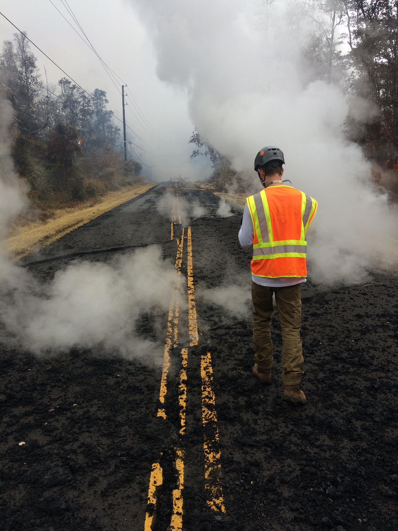
Rates of motion increased late this morning on a GPS station 1.5 km (1 mile) southeast of Nanawale Estates. The direction of motion is consistent with renewed movement of magma in the downrift direction (to the northeast).
Rates of seismicity changed little throughout the day; located earthquakes were mostly uprift (west) of Highway 130. Gas emissions remain elevated in the vicinity of fissures.

For maps showing the locations of eruption features, please see https://volcanoes.usgs.gov/volcanoes/kilauea/multimedia_maps.html
For information on volcanic air pollution, please see: http://www.ivhhn.org/vog/

Kīlauea Volcano Summit
Tiltmeters at the summit of Kīlauea Volcano continue to record the deflationary trend of the past week and the lava lake level continues to drop. At about 8:32 a.m. HST, a large rockfall from the steep crater walls into the retreating lake triggered an explosion that generated an ash column above the crater; the ash was blown toward the south-southwest. Rockfalls and explosions that produce ash columns are expected to continue.
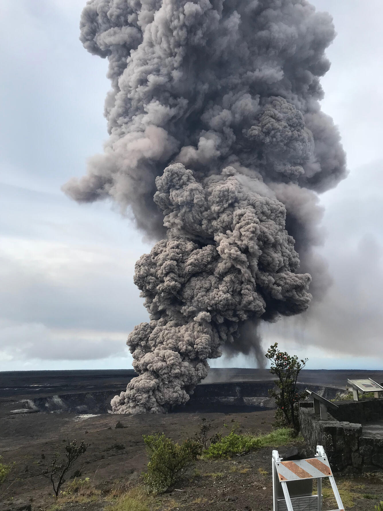
A 3D model of the Overlook crater was created from thermal images collected during an early afternoon helicopter overflight on May 8. Based on the 3D model, the lake level was about 295 m (970 feet) below the floor of Halema'uma'u Crater.
Earthquake activity in the summit remains elevated. Many of these earthquakes are related to the ongoing subsidence of the summit area and earthquakes beneath the south flank of the volcano.
UPDATE, 5/9/18, 8:02am HST
Volcanic Activity Summary: The steady lowering of the lava lake in "Overlook crater" within Halemaʻumaʻu at the summit of Kīlauea Volcano has raised the potential for explosive eruptions in the coming weeks. If the lava column drops to the level of groundwater beneath Kīlauea Caldera, influx of water into the conduit could cause steam-driven explosions. Debris expelled during such explosions could impact the area surrounding Halemaʻumaʻu and the Kīlauea summit. At this time, we cannot say with certainty that explosive activity will occur, how large the explosions could be, or how long such explosive activity could continue.
Residents of the Kīlauea summit area should learn about the hazards of ashfall, stay informed of the status of the volcano and area closures, and review family and business emergency plans.
Resource on volcanic ash hazards: https://volcanoes.usgs.gov/volcanic_ash/
Primary hazards of concern should this activity occur are ballistic projectiles and ashfall.
BALLISTIC PROJECTILES
During steam-driven explosions, ballistic blocks up to 2 m (yards) across could be thrown in all directions to a distance of 1 km (0.6 miles) or more. These blocks could weigh a few kilograms (pounds) to several tons.
Smaller (pebble-size) rocks could be sent several kilometers (miles) from Halemaʻumaʻu, mostly in a downwind direction.
ASHFALL
Presently, during the drawdown of the lava column, rockfalls from the steep enclosing walls of the Overlook crater vent impact the lake and produce small ash clouds. These clouds are very dilute and result in dustings of ash (particles smaller than 2 mm) downwind.
Should steam-driven explosions begin, ash clouds will rise to greater elevations above ground. Minor ashfall could occur over much wider areas, even up to several tens of miles from Halemaʻumaʻu. In 1924, ash may have reached as high as 20,000 feet above sea level. Small amounts of fine ash from these explosions fell over a wide area as far north as North Hilo (Hakalau), in lower Puna, and as far south as Waiohinu.
GAS
Gas emitted during steam-drive explosions will be mainly steam, but will include some sulfur dioxide (SO2) as well. Currently, SO2 emissions remain elevated.
WARNING TIME
Steam-driven explosions at volcanoes typically provide very little warning. Once the lava level reaches the groundwater elevation, onset of continuous ashy plumes or a sequence of violent steam-driven explosions may be the first sign that activity of concern has commenced.
BACKGROUND ON CURRENT EXPLOSIVE POTENTIAL SCENARIO
Kīlauea's lava lake began to drop on May 2, 2018. From its peak on May 2 to the most recent measurement at 9 pm on May 6, the lava lake surface dropped a total of more than 200 m (656 ft). The subsidence was at a relatively constant rate of about 2 meters (yards) per hour.
Measurements of subsidence have not been possible since May 6 because of thick fume and the increasing depth to the lava surface. However, thermal images indicate continued lowering of the lake surface since that time, consistent with deflationary tilt recorded at Kīlauea's summit. Therefore, we infer that the lake surface continues to drop at roughly the same rate. So, while HVO cannot report exact depths of the receding lava lake, we can monitor the overall trend.
USGS and HVO scientists are monitoring changes at the summit 24/7 and watching for signs that hazardous conditions have increased, or may increase. HVO is working closely with Hawai'i Volcanoes National Park and Hawai'i County Civil Defense to respond to this situation.
UPDATE, 5/8/18, 11:18pm HST
Lower East Rift Zone Eruption
The intermittent eruption of lava in Leilani Estates in the lower East Rift Zone of Kīlauea Volcano continues. Activity was focused on the northeast portion of the fissure area; two new fissure segments (13 and 14) broke ground between fissures 7 and 6. Fissure 13 cut across Leilani Street. By 5:00 pm, fissures 13 and 14 were inactive; later, geologists reported loud jetting and booming sounds, and some spattering, at fissure 13. At about 6:00 p.m. reports of booming sounds were reported in the vicinity of Black Sands Beach Subdivision. When HVO geologists arrived soon after, no such sounds were occurring.
Geologists reported the widening of cracks of about 1 to 4 cm (0.4 to 1.6 in) of cracks on Highway 130 and Ali'ili road.
Rates of seismicity changed little throughout the day, but increased during the fissure activity in the afternoon. Gas emissions remain elevated in the vicinity of fissures.
HVO field crews successfully completed the installation of two new co-located seismometers and GPS receivers on the north and south sides of the East Rift Zone. Mahalo to landowners for allowing access and use of their property. HVO geologists will be in the area overnight to track and report to Hawaii County Civil Defense on the activity, and other scientists are tracking the volcano's overall activity 24/7 using various monitoring data streams.
For maps showing the locations of eruption features, please see https://volcanoes.usgs.gov/volcanoes/kilauea/multimedia_maps.html
For information on volcanic air pollution, please see: http://www.ivhhn.org/vog/
Kīlauea Volcano Summit
Tiltmeters at the summit of Kīlauea Volcano continue to record the deflationary trend of the past week and the lava lake level continues to drop. Rockfalls from the steep crater walls into the retreating lake continue to produce occasional ashy plumes above Halema'uma'u crater. These plumes are expected to continue.
Earthquake activity in the summit remains elevated. Many of these earthquakes are related to the ongoing subsidence of the summit area and earthquakes beneath the south flank of the volcano.
UPDATE, 5/8/18, 8:15am HST
As of 7:00 am, the eruption along Kīlauea Volcano's lower East Rift Zone within the Leilani Estates subdivision has paused. Strong emission of gas continues from the fissure system that is now about 2.5 miles long. This pause is likely temporary and resumption of lava emission or additional fissure outbreaks are possible at any time.
Deflationary tilt at the summit of the volcano continues and the lava lake level continues to drop. There is no active lava in the Puʻu ʻŌʻō area. Aftershocks from Friday's magnitude 6.9 earthquake continue and more are expected. Rockfalls into the Overlook vent within Halemaʻumaʻu crater are producing intermittent ash emissions. Seismicity at Kīlauea's summit remains elevated.
USGS/HVO continues to monitor the situation 24/7 in coordination with Hawaii County Civil Defense and other authorities. Field crews are onsite examining the fissure vents, lava flow of yesterday, and searching for any signs of new or resumed activity.
Lower East Rift Zone Observations
Lava emission from fissures was minimal overnight. Strong degassing continues from several fissures. There was no active lava flowing as of 7:00 am this morning.
Deformation of the ground in the area continues. Ground cracks are reported crossing Highway 130 about 1 mile west of the westernmost fissure.
Overall seismicity in the area has not changed significantly overnight and remains elevated. Seismic stations nearest the fissures record seismicity likely related to ongoing vigorous degassing.
Summit Observations: Tiltmeters at the summit continue to record a deflationary trend of the past week and the summit lava lake level continues to drop. Elevated summit sulfur dioxide emission rates persist. Current webcam views are here: https://volcanoes.usgs.gov/volcanoes/kilauea/multimedia_webcams.html
Rockfalls into the Overlook crater are intermittently producing small ash emissions that loft several thousand feet above the ground and travel downwind.
Elevated earthquake activity in the summit area continues following Friday's magnitude-6.9 earthquake and as a consequence of ongoing summit deflation.
Puʻu ʻŌʻō Observations: A tiltmeter on the Puʻu ʻŌʻō cone continues to record the deflationary pattern that followed collapse of the crater floor on April 30. Rockfalls from the steep crater walls will likely continue to collapse intermittently, producing small ashy plumes. The 61g lava flow is no longer active.
Hazard Analysis: Continued eruptive activity (fluctuating and intermittent) in the lower East Rift Zone is likely. New outbreaks or resumption of lava production at existing vents can occur at any time.
Areas downslope of erupting fissures are at risk of lava inundation. The general area of Leilani Estates remains at the greatest risk. However, as the eruption progresses, other areas of the lower East Rift Zone may also be at risk.
High levels of volcanic gas including sulphur dioxide are being emitted from the fissure vents. In addition, smoke from burning houses and burning asphalt is a health concern and should be avoided.
As the lava lake level inside Halemaʻumaʻu drops, rockfalls from the enclosing walls may increase in frequency prompting explosions of spatter from the lake onto the nearby crater rim and lofting plumes of ash. Dustings of ash from these events can occur downwind.
UPDATE, 5/7/2018, 5:59pm HST

Lower East Rift Zone Eruption
The intermittent eruption of lava in the Leilani Estates subdivision in the lower East Rift Zone of Kīlauea Volcano continues. The location of activity today was focused on the southwest portion of the area.
This morning, two new fissure segments broke ground. The first (fissure 11) opened in a forested southwest of Leilani Estates about 9:30 am and was active for only 3 hours. The second (fissure 12) opened about 12:20 between older fissures 10 and 11. By 3:15 pm, both new fissures were in active but the west end of fissure 10 was steaming heavily.
Cracks on Highway 130 widened from 7 cm to 8 cm over the course of the day and additional cracks were found just west of the highway on trend with the eruptive fissures.

For map of recent features discussed above, see https://volcanoes.usgs.gov/volcanoes/kilauea/multimedia_maps.html
Rates of seismicity and deformation changed little throughout the day.
Gas emissions likely remain elevated in the vicinity of fissures.
Residents should remain informed and heed Hawaii County Civil Defense closures, warnings, and messages (http://www.hawaiicounty.gov/active-alerts).
For maps showing the locations of eruption features, please see https://volcanoes.usgs.gov/volcanoes/kilauea/multimedia_maps.html
For information on volcanic air pollution, please see: http://www.ivhhn.org/vog/
HVO geologists will be in the area overnight to track and report to Hawaii County Civil Defense on the activity, and other scientists are closely tracking the volcano's overall activity using various monitoring data streams.
Kīlauea Volcano Summit
Tiltmeters at the summit of Kīlauea Volcano continue to record the deflationary trend of the past several days and the lava lake level continues to drop. Rockfalls from the steep crater walls into the retreating lake continue to produce occasional ashy plumes above Halema'uma'u crater. These plumes are expected to continue.
Earthquake activity in the summit remains elevated but has decreased over the past few days. Many of these earthquakes are related to the ongoing subsidence of the summit area and earthquakes beneath the south flank of the volcano.
This message will be updated tomorrow morning or earlier should conditions change.
HVO Contact: askHVO@usgs.gov
MORE INFORMATION
Activity Summary also available by phone: (808) 967-8862
Subscribe to these messages: https://volcanoes.usgs.gov/vns2/
Webcam images: https://volcanoes.usgs.gov/volcanoes/kilauea/multimedia_webcams.html
Photos/Video: https://volcanoes.usgs.gov/volcanoes/kilauea/multimedia_chronology.html
Lava Flow Maps: https://volcanoes.usgs.gov/volcanoes/kilauea/multimedia_maps.html
Definitions of terms used in update: https://volcanoes.usgs.gov/volcanoes/kilauea/extra/definitions.pdf
Overview of Kīlauea summit (Halemaʻumaʻu) and East Rift Zone (Puʻu ʻŌʻō ) eruptions:
https://volcanoes.usgs.gov/volcanoes/kilauea/extra/background.pdf
Summary of volcanic hazards from Kīlauea eruptions:
https://volcanoes.usgs.gov/volcanoes/kilauea/extra/hazards.pdf
Recent Earthquakes in Hawai'i (map and list):
https://volcanoes.usgs.gov/hvo/earthquakes/
Explanation of Volcano Alert Levels and Aviation Color Codes:
https://volcanoes.usgs.gov/activity/alertsystem/index.php
https://pubs.usgs.gov/fs/2006/3139/
CONTACT INFORMATION:
askHVO@usgs.gov
The Hawaiian Volcano Observatory is one of five volcano observatories within the U.S. Geological Survey and is responsible for monitoring volcanoes and earthquakes in Hawai`i.
UPDATE, 5/7/18, 7:45am HST
Eruption of lava and gas continues at a low level along Kīlauea Volcano's lower East Rift Zone within the Leilani Estates subdivision. Overnight, active emission of lava and spatter at multiple fissures was minimal. This is likely only a pause in activity; additional outbreaks or a resumption of activity are anticipated as seismicity continues in the area. Deflationary tilt at the summit of the volcano continues and the lava lake level continues to drop. There is no active lava in the Puʻu ʻŌʻō area. Aftershocks from Friday's magnitude-6.9 earthquake continue and more should be expected, with larger aftershocks potentially producing rockfalls and associated ash clouds above Puʻu ʻŌʻō and Halemaʻumaʻu crater. Seismicity at Kīlauea's summit remains elevated.
USGS/HVO continues to monitor the situation 24/7. Field crews are onsite this morning examining the fissure vents, lava flow, and searching for any signs of new activity.
Lower East Rift Zone Observations
Lava emission from fissures was minimal overnight. Strong degassing continues from several fissures. Yesterday (5/6/18), a lava flow advanced northward from fissure 8 about 0.9 km (0.6 miles) by 10 a.m., HST before stopping. Deformation of the ground in the area has slowed. Ground cracks are reported crossing Highway 130 west of the eruption site.
Overall seismicity in the area has not changed significantly overnight. Earthquakes continue and seismic stations nearest the fissures record seismicity likely related to ongoing vigorous degassing.

Summit Observations: Tiltmeters at the summit continue to record a deflationary trend of the past week and the summit lava lake level continues to drop. Elevated summit sulfur dioxide emission rates persist. Current webcam views are here: https://volcanoes.usgs.gov/volcanoes/kilauea/multimedia_webcams.html
Elevated earthquake activity in the summit area is continuing following Friday's magnitude-6.9 earthquake and as the summit area continues deflating and rockfalls continue within the Overlook vent.
Puʻu ʻŌʻō Observations: A tiltmeter on the Puʻu ʻŌʻō cone continues to record the deflationary pattern that followed collapse of the crater floor on April 30. Rockfalls from the steep crater walls will likely continue to collapse intermittently, producing small ashy plumes. The 61g lava flow is no longer active.
Hazard Analysis: Continued eruptive activity (fluctuating and intermittent) in the lower East Rift Zone is likely. New outbreaks or resumption of lava production at existing vents can occur at any time.
Areas downslope of erupting fissures are at risk of lava inundation. The general area of Leilani Estates remains at the greatest risk. However, as the eruption progresses, other areas of the lower East Rift Zone may also be at risk.
High levels of volcanic gas including sulphur dioxide are being emitted from the fissure vents. In addition, smoke from burning houses and burning asphalt is a health concern and should be avoided.
As the lava lake level inside Halemaʻumaʻu drops, rockfalls from the enclosing walls may increase in frequency prompting explosions of spatter from the lake onto the nearby crater rim and lofting plumes of ash. Dustings of ash from these events can occur downwind.
Additional aftershocks from the magnitude-6.9 earthquake are expected and some may be strong. Residents are advised to review earthquake preparedness by consulting available resources such as: https://www.shakeout.org/hawaii/dropcoverholdon/
Residents of the Puna District should remain alert, review individual, family, and business emergency plans, and watch for further information about the status of the volcano.
Hawaii County Civil Defense messages regarding conditions, warning, and evacuations may be found at http://www.hawaiicounty.gov/active-alerts/.
UPDATE, 5/6/18, 8:59pm HST
Lower East Rift Zone Eruption
The intermittent eruption of lava in the Leilani Estates subdivision in the lower East Rift Zone of Kīlauea Volcano continues. Fissure 8 erupted lava fountains until about 4 p.m. HST, and the flow advanced slowly northward through the afternoon, even after the lava fountains shut down. Geologists reported that the flow crossed Ho'okopu Road, a distance from fissure 8 of about about 1.1 km (0.6 miles). They also reported new ground cracks in the vicinity of fissures 8 and 9 that were emitting thick steam and gases, but no lava spattering was observed by the time of this status report.
Rates of seismicity and deformation decreased in the past day. The absence of additional deformation in the past day suggests a pause in magma acculumation in the distal part of the intrusion.
For maps showing the locations of eruption features, please see https://volcanoes.usgs.gov/volcanoes/kilauea/multimedia_maps.html
For information on volcanic air pollution, please see: http://www.ivhhn.org/vog/
Kīlauea Volcano Summit
Tiltmeters at the summit of Kīlauea Volcano continue to record the deflationary trend of the past several days. Corresponding to this deflationary trend, the summit lava lake level in Overlook crater dropped about 2 m (6.5 ft) per hour during the day. The lake level has dropped an estimated 220 m (722 ft) since the collapse of Puʻu ʻŌʻō crater on April 30. Rockfalls from the steep crater walls into the retreating lake continue to produce ashy plumes above Halema'uma'u crater. Rockfalls and ashy plumes are expected to continue as the lake level drops.
Earthquake activity in the summit remains at elevated levels. In the past 24 hours, about 31 magnitude 2 earthquakes occurred at depths less than 5 km (3 miles) beneath the summit area (compared to the 24-hour period when 152 magnitude 2 and magnitude 3 earthquakes. These earthquakes are related to the ongoing subsidence of the summit area and earthquakes beneath the south flank of the volcano.

UPDATE, 5/5/18, 11:42pm HST

Lower East Rift Zone Eruption
The intermittent eruption of lava in the Leilani Estates subdivision in the lower East Rift Zone of Kīlauea Volcano continues. Fissure 7 stopped erupting in mid-afternoon. A new fissure erupted near fissures 2 and 7, and lava fountains reached as high as about 70 m (230 ft). New ground cracks were reported on Highway 130, but no heat or escaping steam was subsequently observed.
Seismicity and deformation are consistent with continued accumulation of magma within the rift zone.
Residents should remain informed and heed Hawaii County Civil Defense closures, warnings, and messages (http://www.hawaiicounty.gov/active-alerts).
For maps showing the locations of eruption features, please see https://volcanoes.usgs.gov/volcanoes/kilauea/multimedia_maps.html
For information on volcanic air pollution, please see: http://www.ivhhn.org/vog/
HVO geologists will be in the area overnight to track and report to Hawaii County Civil Defense on the activity, and other scientists are closely tracking the volcano's overall activity using various monitoring data streams.
Kīlauea Volcano Summit
Tiltmeters at the summit of Kīlauea Volcano continue to record the deflationary trend of the past several days. Satellite InSAR data show that between April 23 and May 5, 2018, the summit caldera floor subsided about 10 cm (4 in). Corresponding to this deflationary trend, the summit lava lake level in Overlook crater has dropped about 128 m (518 ft) below the crater rim since April 30. Rockfalls from the crater walls into the retreating lake produced ashy plumes above Halemaumau crater , resulting in light ashfall in the summit area. Rockfalls and ashy plumes are expected to continue as the lake level drops.
Earthquake activity in the summit increased in the past 2 days, coincident with the magnitude-6.9 earthquake on May 4 beneath the south flank of Kīlauea. In the past two days, about 152 magnitude-2 and magnitude-3 earthquakes occurred at depths less than 5 km (3 miles) beneath the summit area. Twenty two magnitude 3 earthquakes were recorded. These earthquakes are related to the ongoing subsidence of the summit area and beneath the south flank of the volcano.

More photos and video are available at the HVO website: https://volcanoes.usgs.gov/volcanoes/kilauea/kilauea_multimedia_15.html
Watch a recent community meeting with USGS scientists that provided an update of the current volcano and earthquake activity. The primary speaker is Tina Neal, Scientist-in-Charge of the Hawaiian Volcano Observatory:https://www.youtube.com/watch?v=cY5-nJ1tpdo&feature=youtu.be
UPDATE, 5/5/18, 11:54am HST
Active eruption of lava and gas continues along Kīlauea Volcano's lower East Rift Zone within the Leilani Estates subdivision. Additional fissure vents producing spatter and small lava flows developed early this morning, and additional outbreaks in the area are likely. Deflationary tilt at the summit of the volcano continues and the lava lake level continues to drop. There is no active lava in the Puʻu ʻŌʻō area. Aftershocks from yesterday's M6.9 earthquake continue and more should be expected, with larger aftershocks potentially producing rockfalls and associated ash clouds above Puʻu ʻŌʻō and Halemaʻumaʻu Crater.
Photos and maps of activity will be posted to the HVO web site as soon as possible. https://volcanoes.usgs.gov/volcanoes/kilauea/multimedia_chronology.html
Residents of the Puna District should remain alert, review individual, family, and business emergency plans, and watch for further information about the status of the volcano.
Hawaii County Civil Defense messages regarding conditions, warning, and evacuations may be found at http://www.hawaiicounty.gov/active-alerts/.
Summit Observations: Deflationary tilt at the summit continues. In concert, the summit lava lake is dropping. Tremor amplitude is fluctuating with lava lake spattering. No large rockfalls or ash plumes related to rockfalls into the lava lake, such as occurred yesterday during the large earthquake sequence, have occurred. Elevated summit sulfur dioxide emission rates persist. Gas emissions remain elevated. Current webcam views are here: https://volcanoes.usgs.gov/volcanoes/kilauea/multimedia_webcams.html
Puʻu ʻŌʻō Observations: Seismicity remains elevated at Puʻu ʻŌʻō but tiltmeters near the cone show no significant deformation overnight. No lava is active in the area and the 61g lava flow is no longer being fed. The summit crater of the cone will likely continue to collapse intermittently producing small plumes of ash. Yesterday, there were several vigorous episodes of ash emission in response to collapse, including immediately after the nearby M6.9 earthquake.
Hazard Analysis: Additional fissure outbreaks producing spatter and lava flows are likely. Locations cannot be forecast with certainty, but new outbreaks thus far have been preceded by ground cracking, then strong steam and volcanic gas release. Areas uprift and downrift of the current fissure zone are the most likely to see further outbreaks.
Areas downslope of an erupting fissure or vent are at risk of lava inundation. Currently, lava flows from active fissures are sluggish and not moving very quickly or far. The general area of the Leilani subdivision remains at greatest risk. However, as the eruption progresses, other areas of the lower East Rift Zone may also be at risk.
High levels of volcanic gas including sulphur dioxide are being emitted from the fissure vents. In addition, smoke from burning houses and burning asphalt is a health concern and should be avoided.
As the lava lake level inside Halemaʻumaʻu drops, rockfalls from the enclosing walls may increase in frequency prompting explosions of spatter from the lake onto the nearby crater rim and lofting plumes of ash. Dustings of ash from these events can occur downwind. Yesterday's strong earthquakes were responsible for some of these plumes and associated ashfall, both from Kīlauea Volcano's summit lava lake and the Puʻu ʻŌʻō vent.
Additional aftershocks from yesterday's M6.9 earthquake are expected and some may be strong. Residents are advised to review earthquake preparedness by consulting available resources such as: https://www.shakeout.org/hawaii/dropcoverholdon
UPDATE, 5/5/18, 11:05am HST - Recent Earthquake Activity Near Kilauea
The HVO recorded a magnitude 6.9 earthquake on Friday, May 4, 2018, at approximately 12:32 p.m. HST. It is the strongest quake in Hawaii since 1975—and the largest in a series of strong earthquakes.
The magnitude 6.9 earthquake was located about 16 km (10 mi) southwest of Leilani Estates, on the Island of Hawai‘i, at a depth of 5.0 km (3.1 mi). A map showing the location of the earthquake is posted on HVO's website at https://volcanoes.usgs.gov/observatories/hvo/hvo_earthquakes.html.
These earthquakes were felt as far away as the Island of Kauai. The maximum intensity of shaking was recorded as VIII on the Mercalli Intensity Scale, indicating severe shaking near the earthquake's epicenter. For more information, see the USGS ShakeMap at https://earthquake.usgs.gov/earthquakes/eventpage/us1000dyad#shakemap.&…;
The mainshock was preceded by a strong magnitude 5.4 earthquake approximately one hour prior. Several aftershocks under the south flank and summit areas of Kīlauea Volcano have already occurred, the largest of which was magnitude 4.8. Strong aftershocks should be expected, and could likely occur for weeks to months into the future.
Like the magnitude 5.0 earthquake yesterday, rockfalls and ash plumes in the Pu‘u ‘Ō‘ō crater were triggered by today's earthquake sequence. HVO scientists are closely monitoring the data. The active eruption in Leilani Estates continues.
For more information on recent earthquakes in Hawai‘i and eruption updates, visit the Hawaiian Volcano Observatory website at https://volcanoes.usgs.gov/hvo/
UPDATE - 5/4/18, 4:04pm HST
Eruption of lava in the Leilani Estates subdivision in the lower East Rift Zone of Kīlauea Volcano continues. Several additional eruptive fissures or vents - each several hundred yards long - have opened over the past day. No significant lava flows have yet formed. Spatter and lava are accumulating primarily within a few tens of yards of the vent.
The sixth and most recent fissure is on the eastern edge of the subdivision. Not all fissure vents remain active and no far-traveled lava flows have formed.
For maps showing the locations of these features, please see https://volcanoes.usgs.gov/volcanoes/kilauea/multimedia_maps.html
HVO geologists will be in the area overnight to track additional activity that may occur, and other scientists are closely tracking the volcano's overall activity using various monitoring data streams.
Seismicity and deformation are consistent with continued accumulation of magma within the rift zone. Additional outbreaks of lava are expected.
Residents should remain informed and heed Hawaii County Civil Defense messages (http://www.hawaiicounty.gov/active-alerts).
UPDATE - 5/4/18, 7:45am HST
An eruption is in progress along Kīlauea Volcano's lower East Rift Zone. Since late afternoon May 3, at least three small fissure vents have opened in Leilani Estates subdivision in the lower Puna district. At this time, activity consists mostly of vigorous lava spattering. Additional outbreaks in the area are likely. Deflationary tilt at the summit of the volcano continues and the lava lake level continues to drop.
Photos and maps of activity will be posted to the HVO web site as they become available. https://volcanoes.usgs.gov/volcanoes/kilauea/multimedia_chronology.html
Lower East Rift Zone:
The first outbreak of lava occurred late in the afternoon of May 3 following days of increased earthquake activity and ground deformation. As of this morning, three separate fissures have opened in the eastern portion of Leilani Estates. Each outbreak has been preceded by ground cracking and strong gas emission. Activity consists primarily of vigorous spattering of lava and development of very short lava flows that have yet to travel more than a few tens of yards from the vent. Earthquake activity in the area remains elevated and ground deformation is continuing. High levels of volcanic gas are reported around the fissure vents.
Residents of the Puna District need to remain alert, review individual, family, and business emergency plans, and watch for further information about the status of the volcano. Hawaii County Civil Defense messages regarding conditions, warning, and evacuations may be found at http://www.hawaiicounty.gov/active-alerts/.
Summit Observations: Deflationary tilt at the summit continues. In concert, the summit lava lake is dropping. Tremor amplitude is fluctuating with lava lake spattering. Elevated summit sulfur dioxide emission rates persist. Gas emissions remain elevated. Current webcam views are here: https://volcanoes.usgs.gov/volcanoes/kilauea/multimedia_webcams.html
Puʻu ʻŌʻō Observations: Seismicity remains elevated at Puʻu ʻŌʻō but tiltmeters near the cone show no significant deformation overnight. During fieldwork at Puʻu ʻŌʻō yesterday, no lava activity was observed in the area. The 61g lava flow is no longer being fed. The summit crater of the cone continues to collapse intermittently producing small plumes of ash; yesterday there were several episodes of ash emission in response to collapse, including immediately after the nearby M5.0 earthquake.
Additionally, seismic activity has increased in the last several hours, with the lastest earthquake being a M6.9 southwest of the Leilani Estates. Click on the USGS Earthquake Hazard link for more information: https://earthquake.usgs.gov/earthquakes/eventpage/us1000dyad#executive
Original Story posted 5/4/18, 6:30am HST
The Kilauea Volcano erupted in the Lower Puna district of Hawai'i, known as the "Big Island" of the Hawaiian Island chain, which is home to roughly 200,000 people and a haven for tourists and adventure seekers.
A notice from the Hawaiian Volcano Observatory (HVO) provides the following details:
The eruption in the Leilani Estates subdivision in the lower East Rift Zone of Kīlauea Volcano that began in late afternoon of May 3rd ended by about 6:30 p.m. HST. Lava spatter and gas bursts erupted from the fissure for about two hours, and lava spread a short distance from the fissure, less than about 10 m (33 ft).
The HVO deployed geologists to the eruption site overnight, and other scientists are monitoring various data streams to the observatory 24/7.
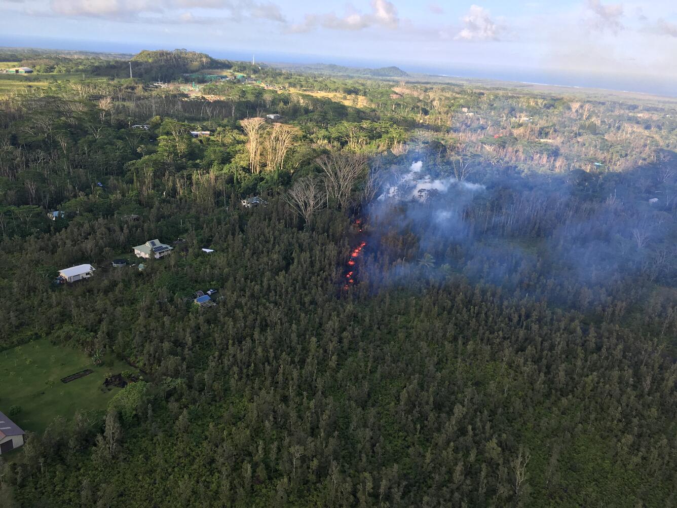
At this time, the fissure is not erupting lava and no other fissures have erupted.
HVO geologists were working near the fissure overnight to track additional activity that may occur, and other scientists are closely tracking the volcano's overall activity.
Recent Observations
Geologists reported that the presence of sulfur gas is quite noticeable around the fissure, typical of active and recently active fissures. The concentration of sulfur dioxide gas is high within tens of meters (yards) of the fissure.
Lava flows did not advance more than about 10 m (33 ft) from the fissure. The flows are no longer active. At this time, no other fissures have erupted from along the rift zone.
Tiltmeters at Kīlauea's summit continue to record deflationary tilt, and the lava lake level has dropped about 37 m (121 ft) in the past 24 hours.
Seismic activity has not changed significantly during the day or since the brief fissure eruption.

Hazard Analysis
The opening phases of fissure eruptions are dynamic and uncertain. Additional erupting fissures and new lava outbreaks may occur. It is not possible at this time to say when and where new vents may occur.
Areas downslope of an erupting fissure or vent are at risk of lava inundation. At this time, the general area of the Leilani subdivision appears to be at greatest risk.

Kilauea Basics
Kīlauea is the youngest and southeastern-most volcano on the Island of Hawai‘i. Topographically, Kīlauea appears as only a bulge on the southeastern flank of Mauna Loa, and so for many years, Kīlauea was thought to be a mere satellite of its giant neighbor, not a separate volcano. However, research over the past few decades shows clearly that Kīlauea has its own magma-plumbing system, extending to the surface from more than 60 km deep in the earth.
More Information
See the Hawaii County Civil Defense messages and alerts for additional information (http://www.hawaiicounty.gov/active-alerts).
Activity Summary also available by phone: (808) 967-8862
Subscribe to these messages: https://volcanoes.usgs.gov/vns2/
Webcam images: https://volcanoes.usgs.gov/volcanoes/kilauea/multimedia_webcams.html
Photos/Video: https://volcanoes.usgs.gov/volcanoes/kilauea/multimedia_chronology.html
(USGS-HVO photos and videos are in the public domain and can be freely downloaded from the HVO website (click on a photo to open a full resolution copy). Please credit "U.S. Geological Survey" for any imagery used.)
Lava Flow Maps: https://volcanoes.usgs.gov/volcanoes/kilauea/multimedia_maps.html
Definitions of terms used in update: https://volcanoes.usgs.gov/volcanoes/kilauea/extra/definitions.pdf
Overview of Kīlauea summit (Halemaʻumaʻu) and East Rift Zone (Puʻu ʻŌʻō ) eruptions:
https://volcanoes.usgs.gov/volcanoes/kilauea/extra/background.pdf
Summary of volcanic hazards from Kīlauea eruptions:
https://volcanoes.usgs.gov/volcanoes/kilauea/extra/hazards.pdf
Recent Earthquakes in Hawai'i (map and list):
https://volcanoes.usgs.gov/hvo/earthquakes/
Explanation of Volcano Alert Levels and Aviation Color Codes:
https://volcanoes.usgs.gov/activity/alertsystem/index.php
https://pubs.usgs.gov/fs/2006/3139/
CONTACT INFORMATION:
askHVO@usgs.gov
The Hawaiian Volcano Observatory is one of five volcano observatories within the U.S. Geological Survey and is responsible for monitoring volcanoes and earthquakes in Hawai`i.
Get Our News
These items are in the RSS feed format (Really Simple Syndication) based on categories such as topics, locations, and more. You can install and RSS reader browser extension, software, or use a third-party service to receive immediate news updates depending on the feed that you have added. If you click the feed links below, they may look strange because they are simply XML code. An RSS reader can easily read this code and push out a notification to you when something new is posted to our site.